There are over 20,000 Grade II* listed buildings in England. This page is a list of these buildings in the district of Tunbridge Wells in Kent.
Tunbridge Wells
| Name | Location | Type | Completed [note 1] | Date designated | Grid ref.[note 2] Geo-coordinates |
Entry number [note 3] | Image |
|---|---|---|---|---|---|---|---|
| Babbs Farmhouse | Benenden, Tunbridge Wells | Farmhouse | 18th century | 20 June 1967 | TQ7913932948 51°04′04″N 0°33′19″E / 51.067909°N 0.555403°E |
1281647 |  Upload Photo |
| Capel Manor House, including the remains of the winter garden and the arcaded retaining wall with balustrade and steps belonging to an earlier house | Horsmonden | House | 1969-70 | 18 September 2013 | TQ7133140019 51°08′02″N 0°26′51″E / 51.133816°N 0.447427°E |
1413746 | 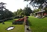 Capel Manor House, including the remains of the winter garden and the arcaded retaining wall with balustrade and steps belonging to an earlier house |
| Church of St George | Benenden | Parish Church | 14th century | 2 June 1967 | TQ8084032670 51°03′54″N 0°34′46″E / 51.064878°N 0.579516°E |
1204075 | |
| Coggers | Benenden | House | C20 | 20 June 1967 | TQ8169433790 51°04′29″N 0°35′32″E / 51.07467°N 0.592253°E |
1085203 | Upload Photo |
| Old Standen | Benenden | House | 18th century | 9 June 1952 | TQ8100530517 51°02′44″N 0°34′51″E / 51.045486°N 0.580792°E |
1336746 | Upload Photo |
| Pympe Manor | Goddard's Green, Benenden | House | 18th century | 9 June 1952 | TQ8272134436 51°04′49″N 0°36′26″E / 51.080147°N 0.607223°E |
1085238 | Upload Photo |
| The Paper Mill | Benenden | House | Later | 9 June 1952 | TQ7852631054 51°03′04″N 0°32′45″E / 51.051085°N 0.545729°E |
1281560 | Upload Photo |
| The Red House | Goddard's Green, Benenden | House | 18th century | 5 July 1993 | TQ8235034668 51°04′56″N 0°36′07″E / 51.082349°N 0.602049°E |
1281552 | Upload Photo |
| Watermill House | Benenden | House | C20 | 9 June 1952 | TQ7979930517 51°02′45″N 0°33′49″E / 51.045865°N 0.563606°E |
1281500 | Upload Photo |
| Parish Church of St Lawrence | Bidborough | Parish Church | 12th century nave | 20 October 1954 | TQ5651143205 51°10′00″N 0°14′14″E / 51.166681°N 0.237173°E |
1248826 |  Parish Church of St Lawrence |
| The Grange | Bidborough | House | Possible earlier house | 20 October 1954 | TQ5641843034 51°09′55″N 0°14′09″E / 51.16517°N 0.235769°E |
1277723 | Upload Photo |
| Archway about 15 Metres East of Brenchley Manor | Brenchley | Gate | Early C20 | 24 August 1990 | TQ6762342094 51°09′13″N 0°23′44″E / 51.153554°N 0.395445°E |
1249084 | Upload Photo |
| Brenchley Manor | Brenchley | House | Probably 18th century | 20 October 1954 | TQ6759542105 51°09′13″N 0°23′42″E / 51.153661°N 0.39505°E |
1277671 | Upload Photo |
| Coach House about 40 Metres North East of Matfield House | Matfield, Brenchley | Coach House | c. 1736 | 20 October 1954 | TQ6585441938 51°09′10″N 0°22′12″E / 51.152668°N 0.370101°E |
1263150 | Upload Photo |
| Stable Building about 50 Metres East of Matfield House | Matfield, Brenchley | Stable | Probably 1736 | 20 October 1954 | TQ6585541919 51°09′09″N 0°22′12″E / 51.152497°N 0.370107°E |
1250647 | Upload Photo |
| Walls, Gate Piers, Railings and Gates to the Garden South and West of Matfield House | Matfield, Brenchley | Gate | Early 18th century | 20 October 1954 | TQ6579841909 51°09′09″N 0°22′09″E / 51.152423°N 0.369288°E |
1263149 | 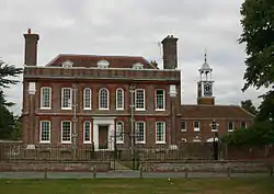 Walls, Gate Piers, Railings and Gates to the Garden South and West of Matfield House |
| Matfield House Cottages | Matfield, Brenchley | Row | Probably circa 1730 | 20 October 1954 | TQ6586841907 51°09′09″N 0°22′13″E / 51.152385°N 0.370287°E |
1250648 | 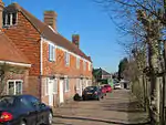 Matfield House Cottages |
| Old Cryals | Brenchley | Farmhouse | Circa early 14th century or earlier | 24 August 1990 | TQ6613140337 51°08′18″N 0°22′24″E / 51.138204°N 0.37332°E |
1249521 | Upload Photo |
| Old Tong Farmhouse | Brenchley | Farmhouse | Circa mid 17th century | 20 October 1954 | TQ6749039735 51°07′57″N 0°23′33″E / 51.132399°N 0.392448°E |
1251138 | Upload Photo |
| Studmore | Brenchley | House | 1662 | 20 October 1954 | TQ6681641824 51°09′05″N 0°23′02″E / 51.151364°N 0.383791°E |
1277603 | Upload Photo |
| Terry's, High Street (Town Farm Cottage) | Brenchley | Cross Passage House | 1990 | 20 October 1954 | TQ6798141778 51°09′02″N 0°24′01″E / 51.15061°N 0.400411°E |
1249608 | 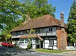 Terry's, High Street (Town Farm Cottage) |
| The Old Palace | Brenchley | House | 17th century | 20 October 1954 | TQ6791241800 51°09′03″N 0°23′58″E / 51.150828°N 0.399436°E |
1263658 | Upload Photo |
| The Old Vicarage | Brenchley | House | Later alterations | 20 October 1954 | TQ6793641759 51°09′02″N 0°23′59″E / 51.150453°N 0.39976°E |
1250138 | Upload Photo |
| The Old Workhouse | Brenchley | House | Converted 1950's | 20 October 1954 | TQ6778441855 51°09′05″N 0°23′51″E / 51.15136°N 0.397633°E |
1250070 | .jpg.webp) The Old Workhouse |
| Tatlingbury Farmhouse, including Garden Walls adjoining to the West | Capel | House | 16th century | 20 October 1954 | TQ6382645009 51°10′51″N 0°20′33″E / 51.180843°N 0.342528°E |
1262828 | Upload Photo |
| The Postern | Tudeley, Capel | House | Dated 1757 | 20 October 1954 | TQ6072246206 51°11′33″N 0°17′55″E / 51.192478°N 0.298692°E |
1253179 | Upload Photo |
| Thistles & Wenhams Cottages | Five Oak Green, Capel | Farmhouse | Dated circa 1436 | 20 October 1954 | TQ6479545550 51°11′08″N 0°21′24″E / 51.185425°N 0.356627°E |
1254121 | Upload Photo |
| Upper Postern Farmhouse | Tudeley, Capel | Farmhouse | Early 18th century | 20 October 1954 | TQ6153746065 51°11′28″N 0°18′37″E / 51.190981°N 0.310281°E |
1253225 | Upload Photo |
| George Hotel, Anderson and Sons Butchers, Lemon Blue Gift Shop, Oliver Fisher Estate Agents, The Cornerhouse Flat. | Cranbrook | Court Room | Before 19th century | 9 June 1952 | TQ7765136078 51°05′47″N 0°32′09″E / 51.096489°N 0.535725°E |
1075155 | 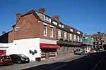 George Hotel, Anderson and Sons Butchers, Lemon Blue Gift Shop, Oliver Fisher Estate Agents, The Cornerhouse Flat. |
| Bangham's Electrical Shop Jeneleen Hairdressers Vegetare | Cranbrook | Cloth Hall | Late 15th century with jettying | 20 June 1967 | TQ7753736053 51°05′47″N 0°32′03″E / 51.096299°N 0.534087°E |
1084827 | Upload Photo |
| Bell Cottage & Sissinghurst Post Office | Sissinghurst, Cranbrook | House | 1986 | 20 June 1967 | TQ7941637524 51°06′32″N 0°33′42″E / 51.108929°N 0.561623°E |
1084811 | 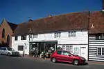 Bell Cottage & Sissinghurst Post Office |
| Bettenham Manor and Oast to the West | Three Chimneys, Cranbrook | House | 17th century | 20 June 1967 | TQ8169239118 51°07′21″N 0°35′42″E / 51.122531°N 0.594903°E |
1338661 | 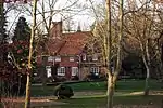 Bettenham Manor and Oast to the West |
| Coursehorn | Cranbrook | Cloth Hall | 16th century | 20 June 1967 | TQ7925835826 51°05′37″N 0°33′31″E / 51.093725°N 0.558526°E |
1336925 | Upload Photo |
| Cranbrook School House and Walls to South | Cranbrook | Gate | 1727 | 9 June 1952 | TQ7779336070 51°05′47″N 0°32′16″E / 51.096373°N 0.537747°E |
1084796 | Upload Photo |
| Friezley and Weavers | Cranbrook | Cloth Hall | 1952 | 9 June 1952 | TQ7743238209 51°06′57″N 0°32′01″E / 51.1157°N 0.533648°E |
1347912 | 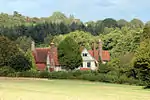 Friezley and Weavers |
| Glassenbury Park House | Cranbrook | Country House | Late 15th century | 27 January 1977 | TQ7470836648 51°06′09″N 0°29′38″E / 51.102513°N 0.494014°E |
1101470 | Upload Photo |
| Goddards Green Farmhouse | Cranbrook | Farmhouse | 1986 | 9 June 1952 | TQ7671035799 51°05′39″N 0°31′20″E / 51.094273°N 0.522164°E |
1084183 | Upload Photo |
| Hill House | Cranbrook | House | 1952 | 9 June 1952 | TQ7786135906 51°05′42″N 0°32′19″E / 51.094878°N 0.538637°E |
1084833 | 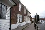 Hill House |
| King's Head House | Sissinghurst, Cranbrook | House | 16th century | 20 June 1967 | TQ7934037534 51°06′33″N 0°33′38″E / 51.109043°N 0.560544°E |
1084814 |  King's Head House |
| Providence Chapel | Cranbrook | Presbyterian Chapel | 1795 | 9 June 1967 | TQ7767836008 51°05′45″N 0°32′10″E / 51.095851°N 0.536076°E |
1084808 |  Providence Chapel |
| Shepherds | Cranbrook | House | 1952 | 9 June 1952 | TQ7732535994 51°05′45″N 0°31′52″E / 51.095835°N 0.531033°E |
1336920 | Upload Photo |
| The Old Cloth Hall | Cranbrook | House | 1952 | 9 June 1952 | TQ7910235728 51°05′34″N 0°33′23″E / 51.092893°N 0.556252°E |
1084868 | Upload Photo |
| The Priest's House at Sissinghurst Castle | Cranbrook | Priests House | 16th century | 20 June 1967 | TQ8081638363 51°06′58″N 0°34′55″E / 51.116026°N 0.582021°E |
1346286 | 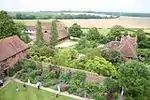 The Priest's House at Sissinghurst Castle |
| The South Cottage | Sissinghurst, Cranbrook | House | Fragment of c1570 house | 20 June 1967 | TQ8084238283 51°06′55″N 0°34′56″E / 51.115299°N 0.582352°E |
1084164 | Upload Photo |
| Wilsley Hotel | Cranbrook | House | 1864-70 | 20 June 1967 | TQ7784736943 51°06′15″N 0°32′20″E / 51.104198°N 0.538947°E |
1346269 | Upload Photo |
| Balcombe Farmhouse | Frittenden | House | altered 16th century | 20 June 1967 | TQ8207640916 51°08′19″N 0°36′05″E / 51.13856°N 0.601292°E |
1338652 | Upload Photo |
| Church of St Mary | Frittenden | Parish Church | Medieval | 20 June 1967 | TQ8131840953 51°08′21″N 0°35′26″E / 51.139133°N 0.590487°E |
1116253 | .jpg.webp) Church of St Mary |
| Great Bubhurst | Frittenden | House | altered 1790 | 20 June 1967 | TQ8315941712 51°08′43″N 0°37′02″E / 51.145365°N 0.61716°E |
1084760 | Upload Photo |
| Ponds Farmhouse | Frittenden | Jettied House | 15th century | 9 June 1952 | TQ8260740909 51°08′18″N 0°36′32″E / 51.138329°N 0.608871°E |
1186236 | Upload Photo |
| Barn and Stable about 20 Metres North of Gatehouse | Goudhurst | Barn | 16th century | 22 June 1989 | TQ7055835987 51°05′52″N 0°26′04″E / 51.097823°N 0.434484°E |
1338713 | Upload Photo |
| Bedgebury Park, Stable Courts and Garden Terraces | Bedgebury Park, Goudhurst | Country House/School | 1688 core | 19 March 1982 | TQ7211734376 51°04′58″N 0°27′21″E / 51.082885°N 0.455961°E |
1084710 |  Bedgebury Park, Stable Courts and Garden Terraces |
| Church Cottage & Church House | Goudhurst | Continuous Jetty House | c. 1900 | 9 June 1952 | TQ7232737819 51°06′50″N 0°27′38″E / 51.113753°N 0.460598°E |
1338719 | Upload Photo |
| Gatehouse and Restored Early C20 Wall to Front Garden Wall (attached) | Goudhurst | House | 15th century | 9 June 1952 | TQ7055135953 51°05′51″N 0°26′04″E / 51.09752°N 0.434368°E |
1104867 | Upload Photo |
| Maypole | Goudhurst | House | altered 18th century | 22 June 1989 | TQ7272937913 51°06′52″N 0°27′59″E / 51.114476°N 0.466381°E |
1338670 | 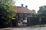 Maypole |
| Pattyndenne Manor and Rear Courtyard | Goudhurst | House | Late 15th century | 9 June 1952 | TQ7199436585 51°06′10″N 0°27′19″E / 51.102767°N 0.455258°E |
1320271 | 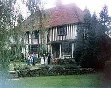 Pattyndenne Manor and Rear Courtyard |
| Risebridge Farmhouse | Risebridge, Goudhurst | Jettied House | Late 16th century | 22 June 1989 | TQ7136736703 51°06′14″N 0°26′47″E / 51.104014°N 0.446367°E |
1084656 | Upload Photo |
| Twyssenden Manor and Wall Projecting | Twyssenden, Goudhurst | House | 16th century to 17th century | 9 June 1952 | TQ7136035207 51°05′26″N 0°26′44″E / 51.090577°N 0.445557°E |
1106244 | 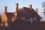 Twyssenden Manor and Wall Projecting |
| Bedgebury Lower School & Collingwood House and Wall attached | Hawkhurst | House | Mid 18th century | 20 June 1967 | TQ7572729313 51°02′11″N 0°30′18″E / 51.036307°N 0.504992°E |
1084640 | Upload Photo |
| Marlborough House School | Hawkhurst | House | 1723 | 9 June 1952 | TQ7529030675 51°02′55″N 0°29′58″E / 51.048676°N 0.499424°E |
1338729 | 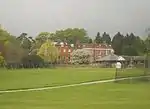 Marlborough House School |
| Wetheringhope and Wall attached | The Moor, Hawkhurst | House | Mid 18th century | 20 June 1967 | TQ7558229564 51°02′19″N 0°30′11″E / 51.038607°N 0.503048°E |
1338750 | Upload Photo |
| Broadford | Horsmonden | Garage | 1954 | 20 October 1954 | TQ7130639689 51°07′51″N 0°26′49″E / 51.130858°N 0.446913°E |
1326674 |  Broadford |
| Grovehurst | Horsmonden | Cross Wing House | 15th century | 20 October 1954 | TQ7160540722 51°08′24″N 0°27′06″E / 51.140049°N 0.451674°E |
1338776 |  Grovehurst |
| Hale Farmhouse | Horsmonden | House | 18th century | 20 October 1954 | TQ6860139271 51°07′40″N 0°24′29″E / 51.127905°N 0.408095°E |
1322819 | Upload Photo |
| Rectory Park & The Old Rectory | Horsmonden | House | Mid 18th century | 20 October 1954 | TQ7032938806 51°07′24″N 0°25′57″E / 51.123217°N 0.432547°E |
1338186 | Upload Photo |
| Spelmonden with Walls attached | Horsmonden | House | C17-C19 | 20 October 1954 | TQ7024637168 51°06′31″N 0°25′50″E / 51.108526°N 0.430589°E |
1338789 | Upload Photo |
| Sprivers and Wall Attached | Horsmonden | House | Extended 16th century | 20 October 1954 | TQ6934039968 51°08′02″N 0°25′08″E / 51.133949°N 0.418973°E |
1107213 |  Sprivers and Wall Attached |
| Coggers Hall | Lamberhurst | Jettied House | Mid-Late 16th century | 20 October 1954 | TQ6762936322 51°06′06″N 0°23′34″E / 51.101696°N 0.392848°E |
1085286 | Upload Photo |
| Downingbury Farmhouse | Pembury | Farmhouse | Early 18th century | 14 April 1986 | TQ6297742250 51°09′23″N 0°19′45″E / 51.156297°N 0.329142°E |
1254438 | Upload Photo |
| Upper Church of St Peter | Pembury | Church | 1846-7 | 20 October 1954 | TQ6260840643 51°08′31″N 0°19′23″E / 51.141963°N 0.323145°E |
1254389 | .JPG.webp) Upper Church of St Peter |
| Alderden Old Manor | Sandhurst | House | C20 | 9 June 1952 | TQ7961529154 51°02′01″N 0°33′37″E / 51.033678°N 0.560309°E |
1085159 | Upload Photo |
| Church of St Nicholas | Sandhurst | Parish Church | 13th century | 20 June 1967 | TQ7905627308 51°01′02″N 0°33′05″E / 51.017269°N 0.551434°E |
1085172 | 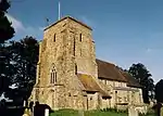 Church of St Nicholas |
| Field Green House | Sandhurst | House | Mid to late 18th century | 20 June 1967 | TQ7853129661 51°02′19″N 0°32′42″E / 51.03857°N 0.545115°E |
1204749 | Upload Photo |
| Sponden Old Hall | Sandhurst | House | Late 16th century | 5 July 1993 | TQ7931329720 51°02′20″N 0°33′23″E / 51.038857°N 0.556286°E |
1280956 | 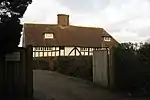 Sponden Old Hall |
| Stables to East of Sir David Salomons' House | Southborough | Tack Room | 1894 | 14 March 1973 | TQ5701141654 51°09′09″N 0°14′37″E / 51.152608°N 0.243642°E |
1298837 | Upload Photo |
| Church of All Saints | Langton Green, Speldhurst | Parish Church | 1862-3 | 24 August 1990 | TQ5418039168 51°07′52″N 0°12′08″E / 51.13104°N 0.202132°E |
1240546 |  Church of All Saints |
| Church of St Mary the Virgin | Speldhurst, Speldhurst | Parish Church | Tower base of 14th century | 20 October 1954 | TQ5535341438 51°09′04″N 0°13′11″E / 51.15112°N 0.219861°E |
1240943 | .jpg.webp) Church of St Mary the Virgin |
| Court Lodge | Old Groombridge, Speldhurst | Continuous Jetty House | Mid/late 15th century | 20 October 1954 | TQ5288437770 51°07′08″N 0°10′59″E / 51.118825°N 0.183032°E |
1240325 | Upload Photo |
| Crown Cottage | Old Groombridge, Speldhurst | House | 19th century | 20 October 1954 | TQ5307037715 51°07′06″N 0°11′08″E / 51.118282°N 0.185664°E |
1240711 | Upload Photo |
| Manor Cottage | Langton Green, Speldhurst | Farmhouse | Probably mid/late 15th century | 25 October 1973 | TQ5445939576 51°08′05″N 0°12′23″E / 51.134631°N 0.206291°E |
1260429 | Upload Photo |
| Mill adjoining to East of Mill House | Old Groombridge, Speldhurst | Grindstone | Probably late 17th century | 24 August 1990 | TQ5306837581 51°07′01″N 0°11′08″E / 51.117078°N 0.185578°E |
1240549 | Upload Photo |
| Mill House | Old Groombridge, Speldhurst | Lobby Entry House | Probably late 17th century | 24 August 1990 | TQ5306037579 51°07′01″N 0°11′08″E / 51.117062°N 0.185463°E |
1240668 | Upload Photo |
| Old Post Office Cottage | Speldhurst | Timber Framed House | Circa 1720-30 | 24 August 1990 | TQ5539341486 51°09′06″N 0°13′14″E / 51.15154°N 0.220453°E |
1260453 | Upload Photo |
| Rose Cottage | Old Groombridge, Speldhurst | House | 19th century | 20 October 1954 | TQ5298737691 51°07′05″N 0°11′04″E / 51.118088°N 0.184469°E |
1067570 | Upload Photo |
| Somerden | Old Groombridge, Speldhurst | House | Possible earlier origins | 20 October 1954 | TQ5308437739 51°07′07″N 0°11′09″E / 51.118493°N 0.185874°E |
1240712 | Upload Photo |
| The Crown including Service Buildings adjoining to North | Old Groombridge, Speldhurst | House | Mid/late 17th century | 20 October 1954 | TQ5304637720 51°07′06″N 0°11′07″E / 51.118333°N 0.185323°E |
1260396 | 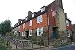 The Crown including Service Buildings adjoining to North |
| The Dower House | Old Groombridge, Speldhurst | House | Circa 1680-90 | 20 October 1954 | TQ5301937634 51°07′03″N 0°11′06″E / 51.117567°N 0.184901°E |
1260835 | Upload Photo |
| The George and Dragon | Speldhurst | House | Late C16/early 17th century | 20 October 1954 | TQ5538441388 51°09′02″N 0°13′13″E / 51.150662°N 0.220282°E |
1241530 | 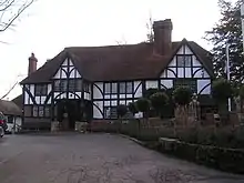 The George and Dragon |
| The Old Butchers | Old Groombridge, Speldhurst | House | Early/mid 18th century | 20 October 1954 | TQ5301537651 51°07′04″N 0°11′05″E / 51.117721°N 0.184851°E |
1067566 |  The Old Butchers |
| The Old Town Post Office including Front Area Railings | Old Groombridge, Speldhurst | House | 19th century | 20 October 1954 | TQ5300637663 51°07′04″N 0°11′05″E / 51.117831°N 0.184728°E |
1067567 | The Old Town Post Office including Front Area Railings |
| 3 and 4 Bird–in–hand Street | Old Groombridge, Speldhurst | House | 19th century | 20 October 1954 | TQ5298137702 51°07′05″N 0°11′04″E / 51.118188°N 0.184388°E |
1067571 |  3 and 4 Bird–in–hand Street |
| 5 Bird–in–hand Street | Old Groombridge, Speldhurst | House | 19th century | 20 October 1954 | TQ5297437725 51°07′06″N 0°11′03″E / 51.118397°N 0.184297°E |
1067572 |  5 Bird–in–hand Street |
| 6 Bird–in–hand Street | Old Groombridge, Speldhurst | House | Possible earlier origins | 20 October 1954 | TQ5297037730 51°07′06″N 0°11′03″E / 51.118443°N 0.184242°E |
1356671 | 6 Bird–in–hand Street |
| 7 Bird–in–hand Street | Old Groombridge, Speldhurst | House | Possible earlier origins | 20 October 1954 | TQ5296637734 51°07′07″N 0°11′03″E / 51.11848°N 0.184187°E |
1067573 | 7 Bird–in–hand Street |
| 11 Bird–in–hand Street | Old Groombridge, Speldhurst | House | 19th century | 20 October 1954 | TQ5295037751 51°07′07″N 0°11′02″E / 51.118637°N 0.183966°E |
1261076 | 11 Bird–in–hand Street |
| 12 Bird–in–hand Street | Old Groombridge, Speldhurst | House | Probably 18th century | 20 October 1954 | TQ5294437746 51°07′07″N 0°11′02″E / 51.118594°N 0.183878°E |
1356672 | Upload Photo |
| 1 and 2 The Walks | Old Groombridge, Speldhurst | House | 19th century | 20 October 1954 | TQ5299437721 51°07′06″N 0°11′04″E / 51.118356°N 0.184581°E |
1241636 | Upload Photo |
| 3, 4, 5 and 6 The Walks | Old Groombridge, Speldhurst | House | Late 18th century or 19th century | 20 October 1954 | TQ5301137717 51°07′06″N 0°11′05″E / 51.118315°N 0.184822°E |
1241720 | Upload Photo |
| 7, 8 and 9 The Walks | Old Groombridge, Speldhurst | House | Late C17/early 18th century | 20 October 1954 | TQ5303037721 51°07′06″N 0°11′06″E / 51.118346°N 0.185095°E |
1241637 | Upload Photo |
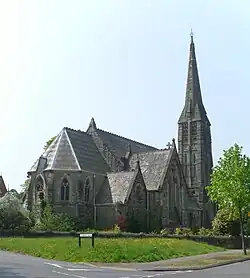
| Church of St Mark | Broadwater Down, Tunbridge Wells | Parish Hall | 1985 | 7 June 1974 | TQ5820637964 51°07′09″N 0°15′33″E / 51.119125°N 0.259095°E |
1083780 | |
| Lecture Hall, former Mount Pleasant Congregational Church | Tunbridge Wells | Assembly Hall | 1848 | 20 May 1952 | TQ5843939566 51°08′00″N 0°15′47″E / 51.133455°N 0.263125°E |
1084464 |  Lecture Hall, former Mount Pleasant Congregational Church |
| Parish Church of St Barnabas | Tunbridge Wells | Parish Church | 1887-9 | 7 June 1974 | TQ5887840146 51°08′19″N 0°16′11″E / 51.138544°N 0.26965°E |
1338860 |  Parish Church of St Barnabas |
| Rock Villa | Tunbridge Wells | Villa | 18th century | 20 May 1952 | TQ5827539705 51°08′05″N 0°15′39″E / 51.134749°N 0.260844°E |
1338834 | 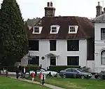 Rock Villa |
| Trinity Arts Centre (formerly Holy Trinity Church) | Tunbridge Wells | Arts Centre | 1981 | 20 May 1952 | TQ5837539492 51°07′58″N 0°15′44″E / 51.132807°N 0.262179°E |
1223642 | |
| 7 The Pantiles | Tunbridge Wells | House | 1660 | 20 May 1952 | TQ5814738781 51°07′35″N 0°15′31″E / 51.126482°N 0.258611°E |
1066598 | Upload Photo |
| 39 and 41 The Pantiles | Tunbridge Wells | Apartment | Later | 20 May 1952 | TQ5809838730 51°07′34″N 0°15′28″E / 51.126037°N 0.257889°E |
1084436 | Upload Photo |
| 68 London Road (including 47 Church Road) | Tunbridge Wells | House | 18th century | 20 May 1952 | TQ5818639437 51°07′57″N 0°15′34″E / 51.132365°N 0.259456°E |
1225330 |  68 London Road (including 47 Church Road) |
| 72 London Road | Tunbridge Wells | Villa | Early 19th century | 20 May 1952 | TQ5820839503 51°07′59″N 0°15′35″E / 51.132952°N 0.259799°E |
1084485 | 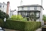 72 London Road |
| 1–17 Calverley Park Crescent | Tunbridge Wells | Bath House | 1828-35 | 24 November 1966 | TQ5875539459 51°07′57″N 0°16′03″E / 51.132406°N 0.267591°E |
1346502 | 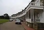 1–17 Calverley Park Crescent |
| Farnborough Lodge | Calverley Park | House | Early 19th century | 20 May 1952 | TQ5885539060 51°07′44″N 0°16′08″E / 51.128793°N 0.268843°E |
1281705 | 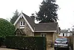 Farnborough Lodge |
| Keston Lodge | Calverley Park | House | Early 19th century | 20 May 1952 | TQ5882139481 51°07′57″N 0°16′07″E / 51.132585°N 0.268543°E |
1083781 | 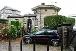 Keston Lodge |
| Victoria Lodge | Calverley Park | House | Early 19th century | 20 May 1952 | TQ5869939407 51°07′55″N 0°16′00″E / 51.131954°N 0.266768°E |
1203351 | 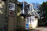 Victoria Lodge |
| 1 Calverley Park | Calverley Park | House | Early 19th century | 20 May 1952 | TQ5879139409 51°07′55″N 0°16′05″E / 51.131947°N 0.268083°E |
1203357 | 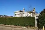 1 Calverley Park |
| 2 Calverley Park | Calverley Park | House | Early 19th century | 20 May 1952 | TQ5885639456 51°07′56″N 0°16′09″E / 51.132351°N 0.269032°E |
1083782 | Upload Photo |
| 3 Calverley Park | Calverley Park | Villa | Victorian | 20 May 1952 | TQ5891139435 51°07′56″N 0°16′11″E / 51.132147°N 0.269808°E |
1083783 | Upload Photo |
| 4 Calverley Park | Calverley Park | Villa | Early Victorian | 20 May 1952 | TQ5895939414 51°07′55″N 0°16′14″E / 51.131945°N 0.270484°E |
1203389 | Upload Photo |
| 5 and 6 Calverley Park | Calverley Park | Semi Detached House | Early 19th century | 20 May 1952 | TQ5882439405 51°07′55″N 0°16′07″E / 51.131901°N 0.268552°E |
1083784 | Upload Photo |
| 7 Calverley Park | Calverley Park | House | Early 19th century | 20 May 1952 | TQ5886039402 51°07′55″N 0°16′09″E / 51.131865°N 0.269065°E |
1083785 | Upload Photo |
| 8 Calverley Park | Calverley Park | House | Early 19th century | 20 May 1952 | TQ5890539384 51°07′54″N 0°16′11″E / 51.13169°N 0.2697°E |
1203390 | Upload Photo |
| 9 and 10 Calverley Park | Calverley Park | Semi Detached House | Early 19th century | 20 May 1952 | TQ5892839360 51°07′53″N 0°16′12″E / 51.131468°N 0.270018°E |
1083786 | Upload Photo |
| 11 Calverley Park | Calverley Park | House | Early 19th century | 20 May 1952 | TQ5896639340 51°07′53″N 0°16′14″E / 51.131278°N 0.270551°E |
1083787 | Upload Photo |
| 12 Calverley Park | Calverley Park | House | Early 19th century | 20 May 1952 | TQ5898339319 51°07′52″N 0°16′15″E / 51.131085°N 0.270785°E |
1346497 | Upload Photo |
| 13 Calverley Park | Calverley Park | House | Early 19th century | 20 May 1952 | TQ5899639287 51°07′51″N 0°16′15″E / 51.130794°N 0.270956°E |
1083744 | Upload Photo |
| 14 Calverley Park | Calverley Park | House | Early 19th century | 20 May 1952 | TQ5899839261 51°07′50″N 0°16′16″E / 51.130559°N 0.270973°E |
1083745 |  14 Calverley Park |
| 15 Calverley Park | Calverley Park | House | Early 19th century | 20 May 1952 | TQ5899439234 51°07′49″N 0°16′15″E / 51.130318°N 0.270904°E |
1346498 | Upload Photo |
| 16 Calverley Park | Calverley Park | House | Early 19th century | 20 May 1952 | TQ5898439210 51°07′48″N 0°16′15″E / 51.130105°N 0.270751°E |
1083746 | 16 Calverley Park |
| 17 Calverley Park | Calverley Park | House | Early 19th century | 20 May 1952 | TQ5897439187 51°07′48″N 0°16′14″E / 51.129901°N 0.270598°E |
1346499 | Upload Photo |
| 18 Calverley Park | Calverley Park | House | Early 19th century | 20 May 1952 | TQ5896339168 51°07′47″N 0°16′14″E / 51.129733°N 0.270433°E |
1083747 | 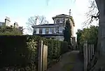 18 Calverley Park |
| 19 Calverley Park | Calverley Park | House | Early 19th century | 20 May 1952 | TQ5895339145 51°07′46″N 0°16′13″E / 51.12953°N 0.27028°E |
1083748 | Upload Photo |
| 20 Calverley Park | Calverley Park | House | Early 19th century | 20 May 1952 | TQ5894639129 51°07′46″N 0°16′13″E / 51.129388°N 0.270173°E |
1346500 | Upload Photo |
| 21 Calverley Park | Calverley Park | House | Early 19th century | 20 May 1952 | TQ5893339108 51°07′45″N 0°16′12″E / 51.129203°N 0.269978°E |
1083749 | Upload Photo |
| 22 Calverley Park | Calverley Park | House | Early 19 | 20 May 1952 | TQ5892939089 51°07′45″N 0°16′12″E / 51.129033°N 0.269912°E |
1346501 | Upload Photo |
| 23 Calverley Park | Calverley Park | House | Early 19th century | 20 May 1952 | TQ5891639071 51°07′44″N 0°16′11″E / 51.128875°N 0.269719°E |
1083750 | Upload Photo |
| 24 Calverley Park | Calverley Park | House | Early 19th century | 20 May 1952 | TQ5890839055 51°07′43″N 0°16′11″E / 51.128733°N 0.269598°E |
1083751 | Upload Photo |

.JPG.webp)
Notes
- ↑ The date given is the date used by Historic England as significant for the initial building or that of an important part in the structure's description.
- ↑ Sometimes known as OSGB36, the grid reference is based on the British national grid reference system used by the Ordnance Survey.
- ↑ The "List Entry Number" is a unique number assigned to each listed building and scheduled monument by Historic England.
External links
This article is issued from Wikipedia. The text is licensed under Creative Commons - Attribution - Sharealike. Additional terms may apply for the media files.