There are over 20,000 Grade II* listed buildings in England. This page is a list of these buildings in the district of Corby in Northamptonshire.
List of buildings
| Name | Location | Type | Completed [note 1] | Date designated | Grid ref.[note 2] Geo-coordinates |
Entry number [note 3] | Image |
|---|---|---|---|---|---|---|---|
| The Bury House | Cottingham | Country house | Late 17th century | 25 October 1951 | SP8439490053 52°30′07″N 0°45′29″W / 52.501857°N 0.758163°W |
1372572 |  Upload Photo |
| Church of St Leonard | Rockingham | Parish church | 13th century | 25 February 1957 | SP8667091447 52°30′51″N 0°43′27″W / 52.514029°N 0.72428°W |
1286197 | .jpg.webp) Church of St Leonard |
| Curtain wall, gates and gatepiers attached to and approx. 50 metres north and west of Rockingham Castle | Rockingham | Gate | 18th century | 6 March 1987 | SP8661491356 52°30′48″N 0°43′30″W / 52.51322°N 0.725128°W |
1051710 | 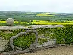 Curtain wall, gates and gatepiers attached to and approx. 50 metres north and west of Rockingham Castle |
| Wall and steps attached to laundry and encircling the Rose Garden, Rockingham Castle | Rockingham | Wall | Mainly 17th and 18th century | 6 March 1987 | SP8669891266 52°30′45″N 0°43′26″W / 52.512398°N 0.723914°W |
1372553 | Upload Photo |
| Wall approx. 10 metres south of garden front, Rockingham Castle | Rockingham | Wall | 17th/18th century | 6 March 1987 | SP8666891277 52°30′45″N 0°43′28″W / 52.512502°N 0.724353°W |
1193462 | Upload Photo |
| Haunt Hill House | Weldon | House | 1636 | 25 October 1951 | SP9252389283 52°29′37″N 0°38′19″W / 52.49362°N 0.638658°W |
1285917 | Upload Photo |
| The Manor House | Weldon | Manor house | Mid-16th–late 17th century | 25 October 1951 | SP9309689534 52°29′45″N 0°37′49″W / 52.495778°N 0.63015°W |
1051693 | Upload Photo |
| Church of St John the Baptist | Corby | Parish church | Late 12th century | 17 March 1953 | SP8983788772 52°29′22″N 0°40′42″W / 52.489476°N 0.678346°W |
1372547 |  Church of St John the Baptist |
| Church of St Michael | Great Oakley | Parish church | 13th century | 25 February 1957 | SP8712485851 52°27′49″N 0°43′09″W / 52.463662°N 0.719053°W |
1372544 | 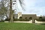 Church of St Michael |
| Great Oakley Hall and attached Gazebo | Great Oakley | Country house | c.1555 | 25 October 1951 | SP8715285902 52°27′51″N 0°43′07″W / 52.464116°N 0.718628°W |
1372545 | 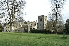 Great Oakley Hall and attached Gazebo |
See also
- Grade I listed buildings in Northamptonshire
- Grade II* listed buildings in Northamptonshire
- Grade II* listed buildings in Daventry (district)
- Grade II* listed buildings in East Northamptonshire
- Grade II* listed buildings in Kettering (borough)
- Grade II* listed buildings in Northampton
- Grade II* listed buildings in South Northamptonshire
- Grade II* listed buildings in Wellingborough (borough)
Notes
- ↑ The date given is the date used by Historic England as significant for the initial building or that of an important part in the structure's description.
- ↑ Sometimes known as OSGB36, the grid reference is based on the British national grid reference system used by the Ordnance Survey.
- ↑ The "List Entry Number" is a unique number assigned to each listed building and scheduled monument by Historic England.
External links
This article is issued from Wikipedia. The text is licensed under Creative Commons - Attribution - Sharealike. Additional terms may apply for the media files.