There are over 20,000 Grade II* listed buildings in England. This page is a list of these buildings in the district of Dartford in Kent.
Listed buildings
| Name | Location | Type | Completed [note 1] | Date designated | Grid ref.[note 2] Geo-coordinates |
Entry number [note 3] | Image |
|---|---|---|---|---|---|---|---|
| Church of Saint Mary Magdalene | Longfield and New Barn, Dartford | Church | 13th century | 1 June 1967 | TQ6033469048 51°23′52″N 0°18′12″E / 51.397811°N 0.303395°E |
1239125 | 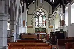 Church of Saint Mary Magdalene |
| Chapter Farmhouse | Southfleet | Farmhouse | 16th century | 1 June 1967 | TQ6168470794 51°24′47″N 0°19′25″E / 51.413115°N 0.323579°E |
1085800 | 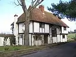 Chapter Farmhouse |
| Friary Court and Old Friary | Southfleet, Dartford | House | 14th century | 1 August 1952 | TQ6127470866 51°24′50″N 0°19′04″E / 51.413879°N 0.317721°E |
1085828 | 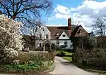 Friary Court and Old Friary |
| The Limes | Southfleet | House | 18th century | 1 June 1967 | TQ6114370664 51°24′44″N 0°18′57″E / 51.412101°N 0.315747°E |
1085795 |  Upload Photo |
| Columbarium at Hawley Manor | Hawley, Sutton-at-Hone and Hawley | Dovecote | 1556 | 1 August 1952 | TQ5488672048 51°25′35″N 0°13′35″E / 51.426278°N 0.226454°E |
1085812 | 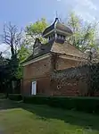 Columbarium at Hawley Manor |
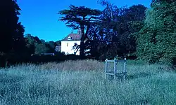
| St John's Jerusalem | Sutton-at-Hone and Hawley | House | 13th century | 1 August 1952 | TQ5588870353 51°24′39″N 0°14′24″E / 51.410775°N 0.24011°E |
1085776 | |
| Church of All Saints | Swanscombe and Greenhithe | Church | 1894 | 17 March 1982 | TQ6057474841 51°26′59″N 0°18′34″E / 51.44979°N 0.309464°E |
1085781 | _-_geograph.org.uk_-_1411878.jpg.webp) Church of All Saints |
| Priory Farmhouse containing the remains of Dartford Priory gatehouse | Dartford | Farmhouse | 1541–45 | 22 December 1953 | TQ5393874402 51°26′52″N 0°12′50″E / 51.447687°N 0.213852°E |
1086030 | 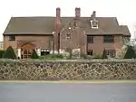 Priory Farmhouse containing the remains of Dartford Priory gatehouse |
| The Royal Victoria and Bull Inn | Dartford | Coaching inn | 1703 | 22 December 1953 | TQ5417174024 51°26′39″N 0°13′01″E / 51.444227°N 0.217038°E |
1086025 | 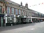 The Royal Victoria and Bull Inn |
| 45 High Street | Dartford | House | Late 18th century | 22 December 1953 | TQ5431174002 51°26′38″N 0°13′09″E / 51.443991°N 0.219041°E |
1336369 | 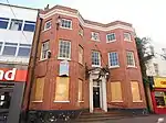 45 High Street |
See also
- Grade I listed buildings in Dartford (borough)
- Grade II* listed buildings in Kent
- Grade II* listed buildings in Sevenoaks (district)
- Grade II* listed buildings in Gravesham
- Grade II* listed buildings in Tonbridge and Malling
- Grade II* listed buildings in Medway
- Grade II* listed buildings in Maidstone (borough)
- Grade II* listed buildings in Tunbridge Wells (borough)
- Grade II* listed buildings in Swale
- Grade II* listed buildings in Ashford (borough)
- Grade II* listed buildings in City of Canterbury
- Grade II* listed buildings in Shepway
- Grade II* listed buildings in Thanet
- Grade II* listed buildings in Dover (district)
Notes
- ↑ The date given is the date used by Historic England as significant for the initial building or that of an important part in the structure's description.
- ↑ Sometimes known as OSGB36, the grid reference is based on the British national grid reference system used by the Ordnance Survey.
- ↑ The "List Entry Number" is a unique number assigned to each listed building and scheduled monument by Historic England.
External links
This article is issued from Wikipedia. The text is licensed under Creative Commons - Attribution - Sharealike. Additional terms may apply for the media files.