There are over 20,000 Grade II* listed buildings in England. This page is a list of these buildings in the district of Ryedale in North Yorkshire.
Ryedale
| Name | Location | Type | Completed [note 1] | Date designated | Grid ref.[note 2] Geo-coordinates |
Entry number [note 3] | Image |
|---|---|---|---|---|---|---|---|
| Aislaby Hall, front Wall and Gate Piers | Aislaby, Ryedale | House | Earlier than 1733 | 10 November 1953 | SE7759485681 54°15′39″N 0°48′37″W / 54.260921°N 0.810302°W |
1289105 |  Upload Photo |
| Gazebo and Garden Walls attached to Aislaby Hall | Aislaby, Ryedale | Garden Wall | Early 18th century | 10 November 1953 | SE7767285660 54°15′39″N 0°48′33″W / 54.26072°N 0.80911°W |
1203792 | Upload Photo |
| Church of Saint John (previously St Mary) | Allerston, Ryedale | Church | 14th century | 10 January 1953 | SE8782982912 54°14′04″N 0°39′15″W / 54.23439°N 0.654032°W |
1149549 | |
| Birdsall House | The Park, Birdsall, Ryedale | Country House | Late 16th century | 20 September 1951 | SE8150664842 54°04′23″N 0°45′21″W / 54.07307°N 0.755891°W |
1174509 | |
| Aldby Park | Buttercrambe, Buttercrambe with Bossall, Ryedale | Country House | 1726 | 24 January 1985 | SE7324458407 54°00′59″N 0°53′01″W / 54.016484°N 0.883676°W |
1149646 | 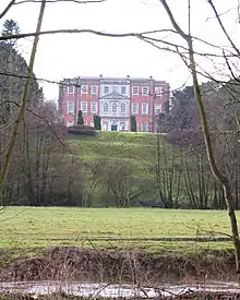 Aldby Park |
| Church of St John the Evangelist | Buttercrambe, Buttercrambe with Bossall, Ryedale | Church | c. 1200 | 29 January 1953 | SE7339158108 54°00′50″N 0°52′53″W / 54.013777°N 0.881505°W |
1315747 | 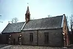 Church of St John the Evangelist |
| Church of St Mary the Virgin | Ebberston and Yedingham, Ryedale | Church | 12th century | 10 November 1953 | SE8918783316 54°14′16″N 0°37′59″W / 54.237785°N 0.633085°W |
1315780 | _-_geograph.org.uk_-_190552.jpg.webp) Church of St Mary the Virgin |
| The Old Abbey and attached Farmbuilding | Ebberston and Yedingham, Ryedale | Farmhouse | Late 17th century | 10 November 1953 | SE8959079788 54°12′22″N 0°37′41″W / 54.206017°N 0.627954°W |
1149556 | Upload Photo |
| Wall of Cascade about 100m north of Ebberston Hall | Ebberston and Yedingham, Ryedale | Wall | c. 1718 | 5 February 1986 | SE8925683529 54°14′23″N 0°37′55″W / 54.239687°N 0.631963°W |
1315781 | Upload Photo |
| Wall of Cascade about 50m north of Ebberston Hall | Ebberston and Yedingham, Ryedale | Wall | c. 1718 | 5 February 1986 | SE8924983479 54°14′21″N 0°37′56″W / 54.239239°N 0.632085°W |
1206196 | Upload Photo |
| Westwood Farmhouse | Ebberston and Yedingham, Ryedale | Farmhouse | Mid 18th century | 5 February 1986 | SE8986582455 54°13′48″N 0°37′23″W / 54.229931°N 0.622943°W |
1280313 | 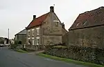 Westwood Farmhouse |
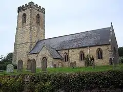
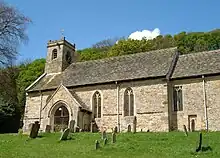
| Church of St Michael | Edstone, Ryedale | Church | 13th century | 14 July 1955 | SE7055184005 54°14′49″N 0°55′08″W / 54.246879°N 0.918795°W |
1149266 | 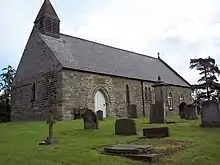 Church of St Michael |
| Duck House | Farndale East, Ryedale | Farmhouse | C16-C17 | 24 June 1987 | SE6830094621 54°20′33″N 0°57′03″W / 54.342576°N 0.950912°W |
1316011 | Upload Photo |
| Church of All Saints | Foston, Ryedale | Church | 12th century | 25 January 1954 | SE6990865170 54°04′40″N 0°55′59″W / 54.077719°N 0.933023°W |
1315740 | 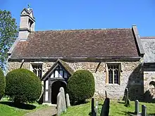 Church of All Saints |
| Foston Rectory | Foston, Ryedale | Vicarage | 1813 | 25 January 1954 | SE6874064859 54°04′30″N 0°57′03″W / 54.075081°N 0.950942°W |
1149629 | Upload Photo |
| Church of St Nicholas | Butterwick, Foxholes, Ryedale | Church | 12th century | 10 October 1966 | SE9913971491 54°07′47″N 0°29′04″W / 54.129719°N 0.484336°W |
1174510 | 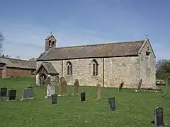 Church of St Nicholas |
| Church of St Nicholas | Ganton, Ryedale | Church | 13th century | 10 October 1966 | SE9898777599 54°11′05″N 0°29′05″W / 54.184624°N 0.484658°W |
1149689 | 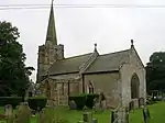 Church of St Nicholas |
| Church of St Mary | Gate Helmsley, Ryedale | Church | Early 13th century | 29 January 1953 | SE6907155217 53°59′18″N 0°56′53″W / 53.988393°N 0.948073°W |
1149613 | |
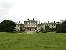
| Arden Hall | Hawnby, Ryedale | Country House | 17th century | 4 January 1955 | SE5195490627 54°18′31″N 1°12′11″W / 54.308608°N 1.203009°W |
1191079 | 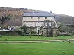 Arden Hall |
| Arden Mill | Hawnby, Ryedale | Mill House | Early 18th century | 31 October 2006 | SE5212490658 54°18′32″N 1°12′01″W / 54.308869°N 1.200391°W |
1391800 | Upload Photo |
| Church of All Saints | Hawnby, Ryedale | Church | 12th century | 4 January 1955 | SE5365189679 54°18′00″N 1°10′38″W / 54.299914°N 1.1771°W |
1191164 | 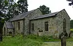 Church of All Saints |
| Canons Garth and Doorway and Walls | Helmsley, Ryedale | House | Late 14th century | 4 January 1955 | SE6122483923 54°14′50″N 1°03′43″W / 54.247341°N 1.061925°W |
1149306 | Upload Photo |
| Church of All Saints | Helmsley, Ryedale | Church | 12th century | 4 January 1955 | SE6118483871 54°14′49″N 1°03′45″W / 54.246878°N 1.062549°W |
1149308 | |
| Church of St Mary Magdelene | Helmsley, Ryedale | Church | 1882 | 18 March 1985 | SE6096890347 54°18′18″N 1°03′52″W / 54.305097°N 1.064547°W |
1149272 | 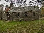 Church of St Mary Magdelene |
| Ha-ha Wall | Duncombe Park Estate, Helmsley, Ryedale | Ha Ha | 18 March 1985 | SE6043183100 54°14′24″N 1°04′27″W / 54.240039°N 1.074259°W |
1149268 | 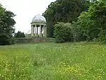 Ha-ha Wall | |
| Laundry | Duncombe Park Estate, Helmsley, Ryedale | Laundry | c. 1730 | 4 January 1955 | SE6031183201 54°14′27″N 1°04′34″W / 54.240961°N 1.076079°W |
1149269 | Upload Photo |
| Memorial to Second Baron Feversham | Helmsley, Ryedale | Commemorative Monument | c. 1867 | 18 March 1985 | SE6127683800 54°14′46″N 1°03′40″W / 54.246229°N 1.061152°W |
1315924 | 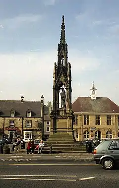 Memorial to Second Baron Feversham |
| St Aidan's Church | Carlton, Helmsley, Ryedale | Former Church | 1884-1887 | 13 February 2001 | SE6101486672 54°16′19″N 1°03′53″W / 54.272068°N 1.064588°W |
1392849 | .jpg.webp) St Aidan's Church |
| Castle Howard Reservoir Basin and Pedestal at centre of Reservoir | Henderskelfe, Ryedale | Reservoir | 1720s | 22 June 1987 | SE7187370204 54°07′22″N 0°54′06″W / 54.122684°N 0.901802°W |
1316052 | .jpg.webp) Castle Howard Reservoir Basin and Pedestal at centre of Reservoir |
| Gate Piers, Walls, Gates and Railings to Entrance of Ray Wood | Ray Wood, Henderskelfe, Ryedale | Gate | Early 18th century | 22 June 1987 | SE7171470158 54°07′20″N 0°54′15″W / 54.122292°N 0.904245°W |
1148970 | Upload Photo |
| Medici Vase and Pedestal | Castle Howard, Henderskelfe, Ryedale | Vase | 1778 | 22 June 1987 | SE7187070102 54°07′18″N 0°54′07″W / 54.121767°N 0.901872°W |
1172761 | Upload Photo |
| Pedestal about 100m west of Temple of Four Winds | Castle Howard, Henderskelfe, Ryedale | Garden Ornament | c. 1720 | 22 June 1987 | SE7208669989 54°07′15″N 0°53′55″W / 54.120722°N 0.898595°W |
1148981 | Upload Photo |
| Pedestal about 150m west of Temple of Four Winds | Henderskelfe, Ryedale | Garden Ornament | c. 1720 | 22 June 1987 | SE7203869991 54°07′15″N 0°53′58″W / 54.120746°N 0.899329°W |
1296449 | Upload Photo |
| Statue of a Satyr with Dog and Grapes, sometimes identified as Bacchus, and Pedestal | Henderskelfe, Ryedale | Statue | c. 1720 | 25 January 1954 | SE7173670054 54°07′17″N 0°54′14″W / 54.121355°N 0.903933°W |
1148982 | Upload Photo |
| Statue of Apollo Belvedre and Pedestal about 90m south-east of Atlas Fountain | Castle Howard, Henderskelfe, Ryedale | Statue | Mid 18th century | 25 January 1954 | SE7169169843 54°07′10″N 0°54′17″W / 54.119465°N 0.904672°W |
1316056 | .jpg.webp) Statue of Apollo Belvedre and Pedestal about 90m south-east of Atlas Fountain |
| Statue of Farnese Hercules and Pedestal | Castle Howard, Henderskelfe, Ryedale | Statue | 1723 | 25 January 1954 | SE7186070023 54°07′16″N 0°54′07″W / 54.121059°N 0.902044°W |
1173011 | Upload Photo |
| Statue of Faun with a Kid and Pedestal about 75m North West of Atlas Fountain | Castle Howard, Henderskelfe, Ryedale | Statue | 1723 | 25 January 1954 | SE7158269961 54°07′14″N 0°54′23″W / 54.12054°N 0.906311°W |
1316054 | Upload Photo |
| Statue of Figure Playing a Lyre and Pedestal | Castle Howard, Henderskelfe, Ryedale | Statue | Early 19th century | 22 June 1987 | SE7158969775 54°07′08″N 0°54′22″W / 54.118868°N 0.906248°W |
1172819 | 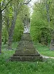 Statue of Figure Playing a Lyre and Pedestal |
| Statue of Meleager and Pedestal | Castle Howard, Henderskelfe, Ryedale | Statue | c. 1720 | 25 January 1954 | SE7198269994 54°07′15″N 0°54′01″W / 54.120781°N 0.900185°W |
1316059 | Upload Photo |
| Statue of Silenus with the Infant Bacchus and Pedestal about 75m north-east of Atlas Fountain | Castle Howard, Henderskelfe, Ryedale | Statue | Mid 18th century | 22 June 1987 | SE7167869989 54°07′15″N 0°54′17″W / 54.120779°N 0.904836°W |
1172928 | Upload Photo |
| The Boar Garden Statue of Wild Boar and Pedestal | Castle Howard, Henderskelfe, Ryedale | Statue | 1768 | 22 June 1987 | SE7151070050 54°07′17″N 0°54′27″W / 54.12135°N 0.907391°W |
1172729 | .jpg.webp) The Boar Garden Statue of Wild Boar and Pedestal |
| The Dairies (East House) | Castle Howard, Henderskelfe, Ryedale | House | c. 1720 | 22 June 1987 | SE7135770349 54°07′27″N 0°54′35″W / 54.124058°N 0.909661°W |
1296531 | Upload Photo |
| Walled Garden Gardener's Cottage | Castle Howard, Henderskelfe, Ryedale | House | Early 19th century | 22 June 1987 | SE7143069886 54°07′12″N 0°54′31″W / 54.119888°N 0.908654°W |
1148983 | 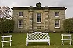 Walled Garden Gardener's Cottage |
| Walled Garden Gate Piers to Central North South Lane | Castle Howard, Henderskelfe, Ryedale | Gate Pier | Early 18th century | 22 June 1987 | SE7141269854 54°07′11″N 0°54′32″W / 54.119603°N 0.908937°W |
1173032 | Upload Photo |
| Walled Garden Statue of Venus De Medici and Pedestal | Castle Howard, Henderskelfe, Ryedale | Statue | Early 18th century | 22 June 1987 | SE7149169956 54°07′14″N 0°54′28″W / 54.120508°N 0.907704°W |
1173045 | 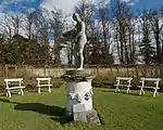 Walled Garden Statue of Venus De Medici and Pedestal |
| Church of All Saints | Hovingham, Ryedale | Church | 10th century | 25 January 1954 | SE6666075730 54°10′23″N 0°58′49″W / 54.173041°N 0.98033°W |
1148990 | .jpg.webp) Church of All Saints |
| Church of St Andrew | Kirby Grindalythe, Ryedale | Church | 12th century | 10 October 1966 | SE9037467517 54°05′44″N 0°37′11″W / 54.095627°N 0.619611°W |
1174946 | .jpg.webp) Church of St Andrew |
| Church of St Laurence | Village, Kirby Misperton, Ryedale | Church | 14th century | 10 November 1953 | SE7792379545 54°12′21″N 0°48′25″W / 54.205737°N 0.806843°W |
1167989 | .jpg.webp) Church of St Laurence |
| Church of St Mary | Levisham, Ryedale | Former Church | 11th century | 10 November 1953 | SE8324290030 54°17′57″N 0°43′21″W / 54.29911°N 0.72241°W |
1280303 | 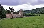 Church of St Mary |
| Church of St Mary | West Lutton, Luttons, Ryedale | Church | 1874-75 | 10 October 1966 | SE9306469225 54°06′38″N 0°34′41″W / 54.110494°N 0.577968°W |
1149659 | 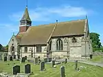 Church of St Mary |
| Church of St Michael | Malton, Ryedale | Church | c. 1150 | 29 September 1951 | SE7856471716 54°08′07″N 0°47′57″W / 54.135292°N 0.799057°W |
1201930 | 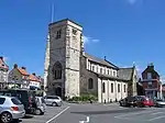 Church of St Michael |
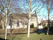
| Malton Lodge | Malton, Ryedale | House | 1993 | 29 September 1951 | SE7897471756 54°08′08″N 0°47′34″W / 54.135589°N 0.792773°W |
1201941 | .jpg.webp) Malton Lodge |
| Malton Meeting House and attached Walls bounding Quaker Burial Ground | Malton, Ryedale | Gate | 18th century | 29 September 1951 | SE7872971890 54°08′13″N 0°47′47″W / 54.136831°N 0.796487°W |
1291410 | _-_geograph.org.uk_-_3233625.jpg.webp) Malton Meeting House and attached Walls bounding Quaker Burial Ground |
| Malton Methodist Church | Malton, Ryedale | Methodist Chapel | 1811 | 10 June 1974 | SE7866371684 54°08′06″N 0°47′51″W / 54.13499°N 0.797551°W |
1220043 | .jpg.webp) Malton Methodist Church |
| Old Abbey and attached Outbuildings | Old Malton, Malton, Ryedale | House | Late 17th century | 29 September 1951 | SE7986172484 54°08′31″N 0°46′44″W / 54.141994°N 0.779009°W |
1201924 | Upload Photo |
| Screen Wall about 35m north-west of Malton Lodge | Malton, Ryedale | Wall | c. 1604 | 29 September 1951 | SE7895071784 54°08′09″N 0°47′35″W / 54.135844°N 0.793133°W |
1219922 | Upload Photo |
| Talbot Hotel | Malton, Ryedale | Hotel | 19th century | 29 September 1951 | SE7847171564 54°08′02″N 0°48′02″W / 54.133941°N 0.80052°W |
1202751 | .jpg.webp) Talbot Hotel |
| Garden Wall and Gateway attached to North West Corner of the Talbot Hotel | Malton, Ryedale | Gate | Early 18th century | 29 September 1951 | SE7840371565 54°08′02″N 0°48′06″W / 54.13396°N 0.80156°W |
1290826 | 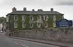 Garden Wall and Gateway attached to North West Corner of the Talbot Hotel |
| The Cross Keys Public House | Malton, Ryedale | Public House | Earlier than late 18th century | 29 September 1951 | SE7864971818 54°08′10″N 0°47′52″W / 54.136196°N 0.79773°W |
1202741 | 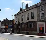 The Cross Keys Public House |
| York House | Malton, Ryedale | Apartment | 1993 | 29 September 1951 | SE7852071578 54°08′03″N 0°47′59″W / 54.134059°N 0.799767°W |
1290865 | .jpg.webp) York House |
| Forecourt Walls, Railings, Gate and Gate Piers at York House | Malton, Ryedale | Gate | Early 18th century | 29 September 1951 | SE7852071585 54°08′03″N 0°47′59″W / 54.134122°N 0.799765°W |
1202749 | Forecourt Walls, Railings, Gate and Gate Piers at York House |
| Church of St Andrew | Normanby, Ryedale | Church | Mid 12th century | 10 November 1953 | SE7348181656 54°13′31″N 0°52′28″W / 54.22536°N 0.874414°W |
1149710 | .jpg.webp) Church of St Andrew |
| Nunnington Bridge | Nunnington, Ryedale | Bridge | Early 18th century | 14 July 1955 | SE6692779470 54°12′24″N 0°58′31″W / 54.206614°N 0.97541°W |
1315700 | .jpg.webp) Nunnington Bridge |
| Church of Saint Oswald | Oswaldkirk, Ryedale | Church | Saxon | 4 January 1955 | SE6208578922 54°12′08″N 1°02′59″W / 54.202298°N 1.049746°W |
1173343 | |
| Oswaldkirk Hall | Oswaldkirk, Ryedale | House | c. 1690 | 4 January 1955 | SE6186278925 54°12′08″N 1°03′11″W / 54.202352°N 1.053163°W |
1149583 | Upload Photo |
| Beck Isle Museum | Pickering, Ryedale | House | Late 18th century | 12 May 1969 | SE7960884161 54°14′49″N 0°46′47″W / 54.246954°N 0.779794°W |
1315853 | |
| Palladian Bridge about 90m north-east of Scampston Hall | Scampston Hall Estate, Scampston, Ryedale | Summerhouse | c. 1775 | 10 October 1966 | SE8657875593 54°10′08″N 0°40′31″W / 54.168842°N 0.675324°W |
1175313 | .jpg.webp) Palladian Bridge about 90m north-east of Scampston Hall |
| Scampston Hall and Gateways, Walls and Terminal Piers attached to South Front | Scampston Hall Estate, Scampston, Ryedale | Country House | Late 17th century | 20 September 1957 | SE8647275529 54°10′06″N 0°40′37″W / 54.168285°N 0.676966°W |
1315717 | 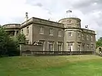 Scampston Hall and Gateways, Walls and Terminal Piers attached to South Front |
| Church of All Saints | Settrington, Ryedale | Church | Late C12-Early 13th century | 10 October 1966 | SE8393370271 54°07′17″N 0°43′02″W / 54.121461°N 0.717307°W |
1173883 | .jpg.webp) Church of All Saints |
| Riding School about 25m north-west of Settrington House | Settrington, Ryedale | Riding School | 1793 | 25 April 1986 | SE8392670218 54°07′16″N 0°43′03″W / 54.120986°N 0.717429°W |
1149512 | Upload Photo |
| Church of St Hilda | Sherburn, Ryedale | Church | Early 12th century | 10 October 1966 | SE9595077433 54°11′01″N 0°31′52″W / 54.183709°N 0.531231°W |
1175457 | 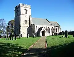 Church of St Hilda |
| Sheriff Hutton Castle | Sheriff Hutton, Ryedale | Castle | 1382 | 25 January 1954 | SE6517066257 54°05′17″N 1°00′19″W / 54.088107°N 1.005193°W |
1149592 | 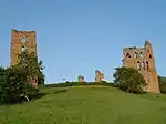 Sheriff Hutton Castle |
| Church of All Saints | Sinnington, Ryedale | Church | 12th century | 10 November 1953 | SE7463886062 54°15′53″N 0°51′20″W / 54.264783°N 0.855576°W |
1288816 | .jpg.webp) Church of All Saints |
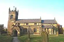
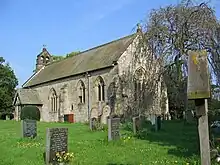
| Church of All Saints, Slingsby | Slingsby, Ryedale | Church | 13th century | 25 January 1954 | SE6968274984 54°09′57″N 0°56′03″W / 54.165937°N 0.934217°W |
1149788 | 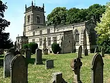 Church of All Saints, Slingsby |
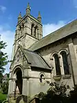
| Church of the Holy Trinity | Stonegrave, Ryedale | Cross | 10th century | 4 January 1955 | SE6557077880 54°11′33″N 0°59′48″W / 54.192501°N 0.996557°W |
1173360 | 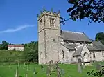 Church of the Holy Trinity |
| Church of Saint Mary | Thixendale, Ryedale | Church | 1868-1870 | 10 October 1966 | SE8422161070 54°02′19″N 0°42′56″W / 54.038741°N 0.715457°W |
1316014 | 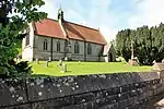 Church of Saint Mary |
| Church of All Saints | Thornton-le-Dale, Ryedale | Church | 14th century | 10 November 1953 | SE8382783127 54°14′13″N 0°42′55″W / 54.236991°N 0.715353°W |
1241098 | .jpg.webp) Church of All Saints |
| Church of Saint Hilda | Ellerburn, Thornton-le-Dale, Ryedale | Church | 11th century | 5 February 1986 | SE8414284218 54°14′48″N 0°42′37″W / 54.246742°N 0.710216°W |
1074194 | .jpg.webp) Church of Saint Hilda |
| The Hall | Thornton-le-Dale, Ryedale | Hall House | Earlier | 10 November 1953 | SE8364783063 54°14′11″N 0°43′05″W / 54.236446°N 0.718132°W |
1241248 | 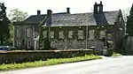 The Hall |
| Church of All Saints | Thorpe Bassett, Ryedale | Church | 12th century | 10 October 1966 | SE8581773459 54°08′59″N 0°41′15″W / 54.149795°N 0.687584°W |
1149491 | |
| Brockfield | Warthill, Ryedale | House | 1804 | 29 January 1953 | SE6630454980 53°59′12″N 0°59′25″W / 53.986625°N 0.990317°W |
1149101 | Upload Photo |
| Church of Saint Mary | Westow, Ryedale | Church | Saxon | 10 October 1966 | SE7593166053 54°05′05″N 0°50′27″W / 54.084802°N 0.840767°W |
1149059 | 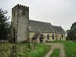 Church of Saint Mary |
| Westow Hall | Westow, Ryedale | House | Late 17th century | 20 September 1951 | SE7541965170 54°04′37″N 0°50′56″W / 54.076943°N 0.848812°W |
1175258 | 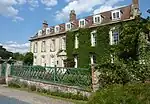 Westow Hall |
| Church of Saint Martin | Wharram Percy, Wharram, Ryedale | Church | Early 10th century | 10 October 1966 | SE8582564209 54°04′00″N 0°41′24″W / 54.066681°N 0.690084°W |
1316019 | 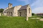 Church of Saint Martin |
| Church of St John Evangelist | Whitwell-on-the-Hill, Ryedale | Church | 1858-60 | 15 July 1985 | SE7242265889 54°05′02″N 0°53′40″W / 54.083833°N 0.894435°W |
1149602 | 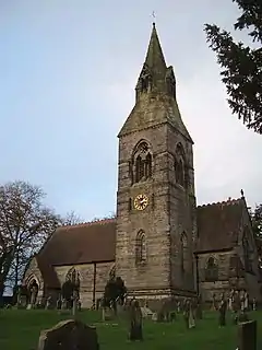 Church of St John Evangelist |
| Church of St Peter | Willerby, Ryedale | Church | 13th century | 10 October 1966 | TA0082879175 54°11′54″N 0°27′21″W / 54.198425°N 0.45593°W |
1175601 | 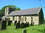 Church of St Peter |
Notes
- ↑ The date given is the date used by Historic England as significant for the initial building or that of an important part in the structure's description.
- ↑ Sometimes known as OSGB36, the grid reference is based on the British national grid reference system used by the Ordnance Survey.
- ↑ The "List Entry Number" is a unique number assigned to each listed building and scheduled monument by Historic England.
External links
This article is issued from Wikipedia. The text is licensed under Creative Commons - Attribution - Sharealike. Additional terms may apply for the media files.