There are over 20,000 Grade II* listed buildings in England. This page is a list of these buildings in the district of Gosport in Hampshire.
Gosport
| Name | Location | Type | Completed [note 1] | Date designated | Grid ref.[note 2] Geo-coordinates |
Entry number [note 3] | Image |
|---|---|---|---|---|---|---|---|
| Chapel of St Luke, Royal Naval Hospital, Haslar | Gosport | Military Chapel | 1762 | 20 April 1983 | SZ6176198739 50°47′06″N 1°07′31″W / 50.784943°N 1.125262°W |
1233560 | 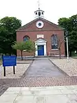 Chapel of St Luke, Royal Naval Hospital, Haslar |
| Church of the Holy Trinity | Gosport | Bell Tower | 1889 | 27 May 1953 | SZ6212599649 50°47′35″N 1°07′12″W / 50.793087°N 1.119945°W |
1234065 |  Church of the Holy Trinity |
| 'e' Magazine (Building 436) and enclosing Walls | Hardway, Gosport | Magazine | 1878 - 1879 | 19 January 1990 | SU6153201273 50°48′28″N 1°07′41″W / 50.807752°N 1.128086°W |
1234622 | _And_Enclosing_Walls.jpg.webp) 'e' Magazine (Building 436) and enclosing Walls |
| Fort Gilkicker | Gilkicker Point, Gosport | Fort | 1865-1871 | 20 April 1983 | SZ6065797494 50°46′26″N 1°08′28″W / 50.773865°N 1.141126°W |
1276716 | |
| Granary, Bakery, Flour Mill, Stores, attached Boiler and Engine House | Royal Clarence Victualling Yard, Gosport | Flour Mill | 1828-1829 | 13 August 1999 | SU6180300673 50°48′08″N 1°07′28″W / 50.802328°N 1.124341°W |
1244463 |  Upload Photo |
| Main Gate and Two Lodges | Clarence Victualling Yard, Gosport | Gate Lodge | 1830-1831 | 13 August 1999 | SU6163100514 50°48′03″N 1°07′37″W / 50.800917°N 1.126809°W |
1272344 | 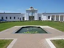 Main Gate and Two Lodges |
| Quick Fire Shell Store (building 433) approx. 12m N of 'a' Magazine, Museum Buildings | Gosport | Boundary Wall | 1770 - 1776 | 19 January 1990 | SU6162301277 50°48′28″N 1°07′36″W / 50.807778°N 1.126794°W |
1393251 | Upload Photo |
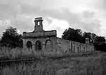
| Railway Station Old Terminal | Gosport | Railway Station | c. 1842 | 10 March 1975 | SU6140000167 50°47′52″N 1°07′49″W / 50.797821°N 1.130144°W |
1234062 | |
| The Crescent | Anglesey, Gosport | Terraced House | 1829 | 27 May 1953 | SZ6036498468 50°46′58″N 1°08′42″W / 50.782653°N 1.145121°W |
1233040 | .jpg.webp) The Crescent |
| The Old Rectory Undercroft | Anglesey, Gosport | House | 18th century | 27 May 1953 | SZ6020398797 50°47′08″N 1°08′50″W / 50.785628°N 1.147351°W |
1276935 | Upload Photo |
| Ward Blocks A, B, C, D, E, F and Centre at Royal Naval Hospital, Haslar | Gosport | Royal Naval Hospital | 1746-1762 | 20 April 1983 | SZ6190698869 50°47′10″N 1°07′23″W / 50.786097°N 1.123183°W |
1233242 |  Ward Blocks A, B, C, D, E, F and Centre at Royal Naval Hospital, Haslar |
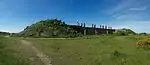
| No. 2 Battery | Gosport | Gun battery | 1860 | 20 April 1983 | SZ5869098925 50°47′13″N 1°10′08″W / 50.786934°N 1.1687906°W |
1276305 |  No. 2 Battery |
Notes
- ↑ The date given is the date used by Historic England as significant for the initial building or that of an important part in the structure's description.
- ↑ Sometimes known as OSGB36, the grid reference is based on the British national grid reference system used by the Ordnance Survey.
- ↑ The "List Entry Number" is a unique number assigned to each listed building and scheduled monument by Historic England.
External links
This article is issued from Wikipedia. The text is licensed under Creative Commons - Attribution - Sharealike. Additional terms may apply for the media files.