
Worcestershire shown within England
There are over 20,000 Grade II* listed buildings in England. This page is a list of these buildings in the district of Bromsgrove in Worcestershire.
Bromsgrove
| Name | Location | Type | Completed [note 1] | Date designated | Grid ref.[note 2] Geo-coordinates |
Entry number [note 3] | Image |
|---|---|---|---|---|---|---|---|
| Church of St Laurence | Alvechurch, Bromsgrove | Parish Church | 12th century | 16 November 1967 | SP0266472445 52°21′00″N 1°57′44″W / 52.350068°N 1.962314°W |
1100225 | 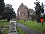 Church of St Laurence |
| Seechem Manor | Alvechurch, Bromsgrove | House | CIRCA LATE 16th century | 16 July 1986 | SP0520172756 52°21′10″N 1°55′30″W / 52.352846°N 1.925064°W |
1100220 |  Upload Photo |
| The Old House | Alvechurch, Bromsgrove | House | Mid 19th century | 23 April 1952 | SP0273972593 52°21′05″N 1°57′40″W / 52.351398°N 1.961212°W |
1100224 | Upload Photo |
| Bradford House and adjoining Garden Walls | Belbroughton, Bromsgrove | House | Late 17th century | 23 April 1952 | SO9208476341 52°23′06″N 2°07′04″W / 52.385041°N 2.117731°W |
1348574 | Upload Photo |
| Chapel about 80m north of Bell Hall | Belbroughton, Bromsgrove | Chapel | c. 1200 | 23 April 1952 | SO9347277192 52°23′34″N 2°05′50″W / 52.39271°N 2.097354°W |
1166799 | Upload Photo |
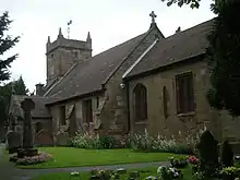
| Church of the Holy Trinity | Belbroughton, Bromsgrove | Parish Church | 12th century | 16 November 1967 | SO9192076862 52°23′23″N 2°07′13″W / 52.389722°N 2.120153°W |
1301271 | 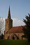 Church of the Holy Trinity |
| Fairfield Court | Fairfield, Belbroughton, Bromsgrove | Farmhouse | 16th century | 23 April 1952 | SO9456775946 52°22′53″N 2°04′52″W / 52.38152°N 2.081243°W |
1100120 | Upload Photo |
| Church of St Leonard | Clent, Bromsgrove | Parish Church | 12th century | 16 November 1967 | SO9285579350 52°24′44″N 2°06′23″W / 52.412102°N 2.106468°W |
1167000 | 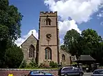 Church of St Leonard |
| Field House | Clent, Bromsgrove | House | Mid 18th century | 16 November 1967 | SO9108879476 52°24′48″N 2°07′57″W / 52.413209°N 2.132449°W |
1166943 | Upload Photo |
| Church of St Michael | Cofton Hackett, Bromsgrove | Parish Church | 14th century | 16 July 1986 | SP0117975352 52°22′34″N 1°59′03″W / 52.376207°N 1.984106°W |
1348568 | 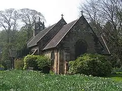 Church of St Michael |
| Cofton Hall | Cofton Hackett, Bromsgrove | Country House | Early 18th century | 23 April 1952 | SP0101575022 52°22′24″N 1°59′11″W / 52.373241°N 1.986516°W |
1167600 | |
| Church of the Holy Trinity and St Mary | Dodford, Dodford with Grafton, Bromsgrove | Parish Church | 1907-8 | 17 July 1986 | SO9321772479 52°21′01″N 2°06′04″W / 52.350336°N 2.101005°W |
1100097 | 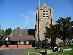 Church of the Holy Trinity and St Mary |
| Dodford Priory | Dodford, Dodford with Grafton, Bromsgrove | Farmhouse | Early 17th century | 23 April 1952 | SO9325572834 52°21′13″N 2°06′02″W / 52.353528°N 2.100454°W |
1100095 | Upload Photo |
| Grafton Manor and Chapel Adjoining to South West | Dodford with Grafton, Bromsgrove | House | Early 16th century | 23 April 1952 | SO9391269183 52°19′15″N 2°05′27″W / 52.320713°N 2.090741°W |
1100131 |  Grafton Manor and Chapel Adjoining to South West |
| Church of St Leonard | Frankley, Bromsgrove | Parish Church | 15th century | 16 November 1967 | SO9989580409 52°25′18″N 2°00′11″W / 52.421671°N 2.00297°W |
1100104 | |
| Church of St John the Baptist | Hagley, Bromsgrove | Parish Church | 13th century | 16 November 1967 | SO9207580769 52°25′29″N 2°07′05″W / 52.424848°N 2.117969°W |
1100106 | 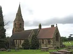 Church of St John the Baptist |
| Obelisk about 3/4 Mile North of Hagley Hall | Wychbury Hill, Hagley, Bromsgrove | Obelisk | Mid 18th century | 23 April 1952 | SO9210181646 52°25′58″N 2°07′03″W / 52.432733°N 2.117608°W |
1167587 | 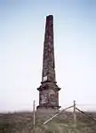 Obelisk about 3/4 Mile North of Hagley Hall |
| Prince of Wales Column | Hagley, Bromsgrove | Column | Mid/Late 18th century | 17 July 1986 | SO9226780976 52°25′36″N 2°06′55″W / 52.426712°N 2.115151°W |
1167574 | 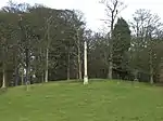 Prince of Wales Column |
| The Castle About 3/4 Mile East of Hagley Hall | Hagley Park, Hagley, Bromsgrove | Folly | 1747 | 23 November 1979 | SO9289680634 52°25′25″N 2°06′21″W / 52.423646°N 2.105893°W |
1348597 | .jpg.webp) The Castle About 3/4 Mile East of Hagley Hall |
| The Old Dairy about 120m north of Hagley Hall | Hagley Park, Hagley, Bromsgrove | Dairy | Mid/Late 18th century | 16 November 1967 | SO9191180854 52°25′32″N 2°07′13″W / 52.42561°N 2.120383°W |
1167568 | Upload Photo |
| The Rotunda about 1/2 Mile north-east of Hagley Hall | Hagley Park, Hagley, Bromsgrove | Rotunda | 1747 | 17 July 1986 | SO9283380953 52°25′35″N 2°06′25″W / 52.426513°N 2.106826°W |
1348598 | .jpg.webp) The Rotunda about 1/2 Mile north-east of Hagley Hall |
| Guesten Hall Roof | Avoncroft Museum of Historic Buildings, Stoke, Bromsgrove | Guest House | c. 1320 | 16 July 1986 | SO9522968422 52°18′50″N 2°04′17″W / 52.313885°N 2.071408°W |
1348531 | Upload Photo |
| Cattespool | Tutnall and Cobley, Bromsgrove | Farmhouse | c. 1640 | 23 April 1952 | SP0068171107 52°20′17″N 1°59′29″W / 52.338045°N 1.991428°W |
1168031 | 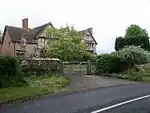 Cattespool |
| Church of St Bartholomew | Tardebigge, Tutnall and Cobley, Bromsgrove | Parish Church | 1777 | 16 November 1967 | SO9955769136 52°19′13″N 2°00′29″W / 52.320325°N 2.007922°W |
1100167 | 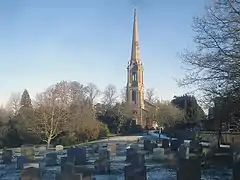 Church of St Bartholomew |
| Chadwick Manor | Lydiate Ash, Bromsgrove | House | Late 17th century | 28 April 1952 | SO9738876071 52°22′58″N 2°02′23″W / 52.382665°N 2.0398°W |
1348486 | 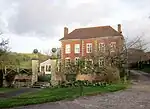 Chadwick Manor |
| 7, Worcester Road. Former Golden Lion Public House | Bromsgrove | Public House | 18th century | 28 April 1952 | SO9584970570 52°20′00″N 2°03′44″W / 52.333201°N 2.06234°W |
1100367 | Upload Photo |
.jpg.webp)
Notes
- ↑ The date given is the date used by Historic England as significant for the initial building or that of an important part in the structure's description.
- ↑ Sometimes known as OSGB36, the grid reference is based on the British national grid reference system used by the Ordnance Survey.
- ↑ The "List Entry Number" is a unique number assigned to each listed building and scheduled monument by Historic England.
References
External links
This article is issued from Wikipedia. The text is licensed under Creative Commons - Attribution - Sharealike. Additional terms may apply for the media files.