There are over 20,000 Grade II* listed buildings in England. This page is a list of these buildings in Blaby.
Blaby
| Name | Location | Type | Completed [note 1] | Date designated | Grid ref.[note 2] Geo-coordinates |
Entry number [note 3] | Image |
|---|---|---|---|---|---|---|---|
| Church of St Michael and All Angels | Cosby, Blaby | Parish Church | 11th century | 7 October 1957 | SP5479994859 52°32′56″N 1°11′36″W / 52.548829°N 1.193297°W |
1361087 |  Church of St Michael and All Angels |
| Church of St John the Baptist | Enderby, Blaby | Parish Church | 14th century | 7 October 1957 | SP5375399428 52°35′24″N 1°12′29″W / 52.590004°N 1.207981°W |
1361072 | 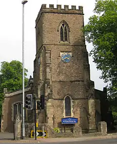 Church of St John the Baptist |
| The Old Tudor Rectory | Glenfields, Blaby | Vicarage | Late C15-early 16th century | 7 October 1957 | SK5373906051 52°38′58″N 1°12′26″W / 52.649539°N 1.207113°W |
1361058 |  Upload Photo |
| Church of St Bartholomew | Kilby, Blaby | Church | 10th century OR 11th century | 7 October 1957 | SP6033694997 52°32′58″N 1°06′42″W / 52.549485°N 1.111626°W |
1177157 | .jpg.webp) Church of St Bartholomew |
| Church of St Bartholomew | Kirby Muxloe, Blaby | Parish Church | Early 13th century | 7 October 1957 | SK5207204658 52°38′14″N 1°13′55″W / 52.637179°N 1.23197°W |
1177204 | 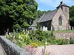 Church of St Bartholomew |
| Church of All Saints | Narborough, Blaby | Parish Church | 15th century | 7 October 1957 | SP5408397538 52°34′23″N 1°12′12″W / 52.572982°N 1.203419°W |
1074720 | |
| Church of St Michael | Stoney Stanton, Blaby | Parish Church | Late 14th century | 7 October 1957 | SP4895594789 52°32′56″N 1°16′46″W / 52.548756°N 1.279482°W |
1074704 |  Church of St Michael |
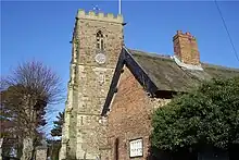
| Church of All Saints | Thurlaston, Blaby | Parish Church | 13th century | 7 October 1957 | SP5021099072 52°35′14″N 1°15′37″W / 52.587142°N 1.260329°W |
1177364 | 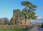 Church of All Saints |
Notes
- ↑ The date given is the date used by Historic England as significant for the initial building or that of an important part in the structure's description.
- ↑ Sometimes known as OSGB36, the grid reference is based on the British national grid reference system used by the Ordnance Survey.
- ↑ The "List Entry Number" is a unique number assigned to each listed building and scheduled monument by Historic England.
External links
This article is issued from Wikipedia. The text is licensed under Creative Commons - Attribution - Sharealike. Additional terms may apply for the media files.