The State Register of Heritage Places is maintained by the Heritage Council of Western Australia. As of 2023, 95 places are heritage-listed in the Shire of Beverley,[1] of which 18 are on the State Register of Heritage Places.[2]
List
The Western Australian State Register of Heritage Places, as of 2023, lists the following 18 state registered places within the Shire of Beverley:
| Place name | Place # | Street number | Street name | Suburb or town | Co-ordinates | Notes & former names | Photo |
|---|---|---|---|---|---|---|---|
| St Paul's Anglican Church & Graveyard, Edwards Crossing | 144 | "Speldhurst", Avon Location | Beverley | 32°04′38″S 116°53′00″E / 32.077258°S 116.883341°E | |||
| Beverley Railway Station | 147 | Vincent Street | Beverley | 32°06′28″S 116°55′32″E / 32.107664°S 116.92556°E | .jpg.webp) | ||
| St Mary's Anglican Church Precinct, Beverley | 150 | 64 | John Street | Beverley | 32°06′15″S 116°55′14″E / 32.104096°S 116.920557°E | Eucalyptus Citriodora-Lemon Scented Gum, Rectory, Lychgate | |
| Beverley Town Hall | 154 | 138, 140&142 | Vincent Street | Beverley | 32°06′33″S 116°55′26″E / 32.109127°S 116.923911°E | .jpg.webp) | |
| Beverley Post Office & Quarters | 157 | Vincent Street | Beverley | 32°06′32″S 116°55′30″E / 32.108784°S 116.925005°E | .jpg.webp) | ||
| Hotel Beverley | 162 | 137 | Vincent Street | Beverley | 32°06′34″S 116°55′31″E / 32.109343°S 116.925174°E | Railway Hotel | .jpg.webp) |
| Bally Bally Hall | 164 | Corner | Caroling-Bally Bally & Bally Bally-County Peak Roads | Beverley | 32°11′06″S 117°07′05″E / 32.185°S 117.118189°E | ||
| Beverley Mechanic's Institute (former) - Site of | 4540 | 138 | Vincent Street | Beverley | 32°06′32″S 116°55′27″E / 32.109022°S 116.924156°E | Site of Present Townhall | |
| Avondale Research Station | 5566 | Lot 3 | Waterhatch Road | Beverley | 32°07′00″S 116°52′08″E / 32.116667°S 116.868861°E | Discovery Farm, Machinery Museum, Avondale State Farm, Avondale Seed Farm | 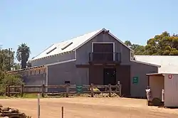 |
| The Sentinels - Town Hall Trees | 5592 | Vincent Street | Beverley | 32°06′34″S 116°55′27″E / 32.109334°S 116.924028°E | |||
| Beverley Judicial Complex | 6291 | Corner | Vincent & Bartram Streets | Beverley | 32°06′29″S 116°55′42″E / 32.108122°S 116.928199°E | Beverley Courthouse, Police Station & Quarters | .jpg.webp) |
| Beverley Fire Station | 14438 | 146 | Vincent Street | Beverley | 32°06′33″S 116°55′25″E / 32.109276°S 116.923573°E | .jpg.webp) | |
| Railway Hotel, Beverley Railway Station | 14916 | Vincent Street | Beverley | [?] | |||
| Eucalyptus Citriodora Tree | 23903 | 64 | John Street | Beverley | [?] | ||
| St Mary's Anglican Rectory | 23915 | 64 | John Street | Beverley | [?] | ||
| St Mary's Anglican Church | 24394 | 64 | John Street | Beverley | 32°06′16″S 116°55′13″E / 32.104334°S 116.920366°E | ||
| Old Police Buildings | 24398 | Lot 28 | Bartram Street | Beverley | 32°06′29″S 116°55′42″E / 32.108122°S 116.928199°E | ||
| Beverley Court House | 24453 | Corner Vincent & Bartram Streets | Beverley | 32°06′28″S 116°55′41″E / 32.10788°S 116.928033°E | .jpg.webp) |
Notes
- ^[?] No coordinates specified by Inherit database
References
- ↑ "Shire of Beverley Heritage Places". inherit.stateheritage.wa.gov.au. Heritage Council of Western Australia. Retrieved 25 February 2023.
- ↑ "Shire of Beverley State Register of Heritage Places". inherit.stateheritage.wa.gov.au. Heritage Council of Western Australia. Retrieved 25 February 2023.
This article is issued from Wikipedia. The text is licensed under Creative Commons - Attribution - Sharealike. Additional terms may apply for the media files.