The State Register of Heritage Places is maintained by the Heritage Council of Western Australia. As of 2023, 641 places are heritage-listed in the City of Stirling,[1] of which 20 are on the State Register of Heritage Places.[2]
List
The Western Australian State Register of Heritage Places, as of 2023, lists the following 20 state registered places within the City of Stirling:
| Place name | Place # | Street number & name | Suburb or town | Co-ordinates | Notes & former names | Photo |
|---|---|---|---|---|---|---|
| Beach House, Trigg Island | 2150 | 352 West Coast Drive | Trigg | 31°52′35″S 115°45′10″E / 31.876404°S 115.752653°E | 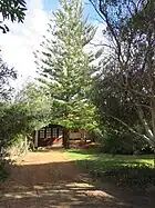 | |
| Astor Theatre | 2425 | 659 Beaufort Street | Mount Lawley | 31°56′03″S 115°52′19″E / 31.934086°S 115.872058°E | Lyceum Theatre, State Theatre, Astor Cinema |  |
| Chapel of St Michael and All Angels | 2430 | 31 Lawley Crescent | Mount Lawley | 31°55′53″S 115°52′33″E / 31.931299°S 115.875820°E | Perth College Chapel |  |
| Windsor Hall | 3320 | 36 Queens Crescent | Mount Lawley | 31°55′56″S 115°52′31″E / 31.932316°S 115.875416°E |  | |
| Cottage, Old Balcatta Road | 3442 | 139 Balcatta Road | Balcatta | 31°51′30″S 115°47′38″E / 31.858323°S 115.793990°E | Daviot Park, Bestry Cottage, Duffy Cottage | |
| Herdsman Lake Settlers Cottage | 3464 | 180 Pearson Street | Churchlands | 31°55′08″S 115°47′40″E / 31.918868°S 115.794484°E | Gava Cottage |  |
| Mount Lawley Tennis Club | 4252 | Rookwood Street | Mount Lawley | 31°55′52″S 115°52′14″E / 31.931021°S 115.870555°E | 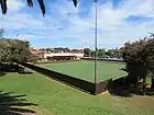 | |
| Beaucott Building | 6185 | 654 Beaufort Street | Mount Lawley | 31°56′04″S 115°52′21″E / 31.934425°S 115.872445°E |  | |
| Inglewood Police Station | 6655 | 867 Beaufort Street | Inglewood | 31°55′20″S 115°53′04″E / 31.922180°S 115.884556°E | ||
| Annesley | 8035 | 49-51 Lawley Crescent | Mount Lawley | 31°55′47″S 115°52′25″E / 31.929597°S 115.873497°E | Annesley Nursing Home, Annesley Rest Home, Annesley Private Hospital |  |
| Osborne Primary School | 8802 | 155 Albert Street | Osborne Park | 31°53′59″S 115°49′31″E / 31.899591°S 115.825373°E | ||
| Balcatta Senior High School | 9812 | 31 Poincaire Street | Balcatta | 31°52′32″S 115°48′46″E / 31.875556°S 115.812778°E | Balcatta High School |  |
| Cooinda House, Mount Lawley | 9818 | 24 Queens Crescent | Mount Lawley | 31°55′57″S 115°52′37″E / 31.932626°S 115.876908°E | Cooinda Education an Employment Hostel, Cooinda Hostel for Aboriginal Girls |  |
| Briggs Kiln Carine | 9842 | Reid Highway | Carine | 31°51′26″S 115°47′46″E / 31.857305°S 115.796101°E | Old Lime Kiln |  |
| Marsala House, Dianella | 9917 | 38 Sycamore Rise | Dianella | 31°52′50″S 115°51′52″E / 31.880480°S 115.864531°E | Dianella's Disco House | 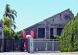 |
| Memorial Gardens & Recreation Reserve, Mount Lawley | 14769 | Lot 6 Queens Crescent | Mount Lawley | 31°55′52″S 115°52′15″E / 31.931080°S 115.870929°E | Mount Lawley Bowling Club & War Memorial, Mount Lawley Tennis Club, Mount Lawley Croquet Club |  |
| War Memorial | 16608 | Corner Clifton & Queens Crescent | Mount Lawley | 31°55′49″S 115°52′15″E / 31.930233°S 115.870801°E |  | |
| Scarborough Clock Tower | 16764 | Intersection The Esplanade & Scarborough Beach Road | Scarborough | 31°53′40″S 115°45′23″E / 31.894404°S 115.756257°E | The Rotary Clock Tower of Scarborough Beach |  |
| Inglewood Police Quarters | 19453 | 867 Beaufort Street | Inglewood | 31°55′20″S 115°53′04″E / 31.922180°S 115.884556°E | ||
| Inglewood Police Station & Police Quarters (former) | 19833 | 867 Beaufort Street | Inglewood | 31°55′20″S 115°53′04″E / 31.922180°S 115.884556°E |
References
- ↑ "City of Stirling Heritage Places". inherit.stateheritage.wa.gov.au. Heritage Council of Western Australia. Retrieved 18 February 2023.
- ↑ "City of Stirling State Register of Heritage Places". inherit.stateheritage.wa.gov.au. Heritage Council of Western Australia. Retrieved 18 February 2023.
This article is issued from Wikipedia. The text is licensed under Creative Commons - Attribution - Sharealike. Additional terms may apply for the media files.