The State Register of Heritage Places is maintained by the Heritage Council of Western Australia. As of 2023, 928 places are heritage-listed in the City of Subiaco,[1] of which 30[note 1] are on the State Register of Heritage Places.[2]
List
The Western Australian State Register of Heritage Places, as of 2023, lists the following 30 state registered places within the City of Subiaco:
| Place name | Place # | Street number | Street name | Suburb or town | Co-ordinates | Notes & former names | Photo |
|---|---|---|---|---|---|---|---|
| Subiaco Primary School | 2434 | 271 | Bagot Road | Subiaco | 31°57′03″S 115°49′23″E / 31.950803°S 115.823094°E | Subiaco Public School, State School, Infants State, Senior School |  |
| King Edward Memorial Hospital for Women | 2438 | Corner | Barker Road & Railway Parade | Subiaco | 31°56′59″S 115°49′07″E / 31.94969°S 115.8186°E | Main Entry Block, Agnes Walsh Nurses Home, Carson House, Harvey House, Industrial School |  |
| Subiaco City Hall | 2443 | 180 | Hamersley Road | Subiaco | 31°57′06″S 115°49′13″E / 31.951783°S 115.820411°E |  | |
| Freemasons Hall (former), Subiaco | 2444 | 181 | Roberts Road | Subiaco | 31°56′44″S 115°49′58″E / 31.945653°S 115.832804°E |  | |
| Perth Modern School | 2450 | 50 & 100 | Roberts Road | Subiaco | 31°56′42″S 115°50′16″E / 31.945°S 115.8377°E |  | |
| Subiaco Fallen Soldiers' Memorial | 2452 | Lot 897 | Rokeby Road | Subiaco | 31°57′08″S 115°49′26″E / 31.952286°S 115.823793°E | Memorial Clock Tower, Subiaco Clock Tower |  |
| Subiaco Hotel | 2453 | 455-465 | Hay Street | Subiaco | 31°56′50″S 115°49′27″E / 31.9472°S 115.8242°E | Murphy's Hotel | .jpg.webp) |
| Regal Theatre | 2454 | 474 | Hay Street | Subiaco | 31°56′49″S 115°49′26″E / 31.9469°S 115.8238°E | Coliseum | .jpg.webp) |
| St Joseph's Church and Presbytery | 3266 | 1 & 9 | Salvado Road | Subiaco | 31°56′34″S 115°49′30″E / 31.9429°S 115.8251°E | St Joseph's Roman Catholic Church |  |
| West Leederville Railway Footbridge | 3290 | Railway Parade | Subiaco | 31°56′34″S 115°49′58″E / 31.942668°S 115.832909°E | |||
| Terrace Houses | 3800 | 18-32 | Catherine Street | Subiaco | 31°56′45″S 115°49′33″E / 31.945929°S 115.825833°E |  | |
| Carson House | 4054 | 374 | Bagot Road | Subiaco | 31°56′58″S 115°49′05″E / 31.949476°S 115.818173°E |  | |
| Industrial School (former) | 4055 | Barker Road | Subiaco | 31°56′57″S 115°49′08″E / 31.949029°S 115.818986°E | Harvey House |  | |
| Subiaco Theatre Centre | 4653 | 180 | Hamersley Road | Subiaco | 31°57′06″S 115°49′13″E / 31.951783°S 115.820411°E | Civic Hall, Rankin Gardens, Subiaco Arts Centre, The Hole in the Wall Theatre |  |
| Electricity Substation, Hay Street | 5424 | 195 | Hay Street | Subiaco | 31°56′50″S 115°49′55″E / 31.947280°S 115.831836°E | State Electricity Commission Sub Station, Distribution Substation, Electric Light Station |  |
| Subiaco Oval Gates | 5478 | 304 | Roberts Road | Subiaco | 31°56′43″S 115°49′43″E / 31.945143°S 115.828737°E | Subiaco Municipal Reserve |  |
| Godfrey House | 5568 | 1 | Roberts Road | Subiaco | 31°56′45″S 115°50′19″E / 31.945754°S 115.838660°E | Chief Resident Medical Officer's Quarters (former) |  |
| Kensington Private Maternity Hospital (former) | 9173 | Corner | Hensman Road & Heytesbury Road | Subiaco | 31°57′15″S 115°49′09″E / 31.954114°S 115.819216°E | Kensington Hospital, Subiaco, Brenda Cherry Centre (1981-2009) |  |
| Wandana Apartment Block | 9186 | 93 | Thomas Street | Subiaco | 31°57′00″S 115°50′02″E / 31.949986°S 115.833754°E | 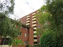 | |
| Attunga Flats, Subiaco | 9187 | 103/105 | Thomas Street | Subiaco | 31°57′04″S 115°49′56″E / 31.951181°S 115.832334°E | Apartments - Attunga | 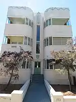 |
| Subiaco Oval | 11923 | 304 | Roberts Road | Subiaco | 31°56′40″S 115°49′48″E / 31.944444°S 115.830000°E | ||
| Thomas Street State School Memorial Gates | 13029 | Thomas Street | Subiaco | 31°56′42″S 115°50′23″E / 31.945101°S 115.839629°E |  | ||
| Australian Fine China, Subiaco | 14465 | Hay Street, Price Street, Atkinson Road, Mouritzen Way, Wunderlich Road & Wembley Crescent | Subiaco | 31°56′44″S 115°49′06″E / 31.945685°S 115.818291°E | Calyx Porcelain, Bristile Ltd, HL Brisbane and Wunderlich Limited | ||
| Old Modernians War Memorial & Honour Roll, Perth Modern School | 15689 | Roberts Road | Subiaco | 31°56′44″S 115°50′16″E / 31.94543°S 115.837763°E |  | ||
| Sunken Garden, University of Western Australia, UWA | 19952 | Mounts Bay Road | Crawley, Nedlands | 31°58′36″S 115°49′00″E / 31.976764°S 115.816683°E |  | ||
| Footpath immediately to the Southern Perimeter Subiaco Oval | 23441 | 304 | Roberts Road | Subiaco | 31°56′40″S 115°49′48″E / 31.944444°S 115.830000°E | ||
| Metropolitan Sewerage Vents | 23992 | Shenton Park, East & West Perth, Highgate, Northbridge | 31°57′24″S 115°48′30″E / 31.956705°S 115.808469°E | Includes Sewerage Vent, Shenton Park (24815) |  | ||
| Subiaco Children's Centre | 24121 | 160 | Hamersley Road | Subiaco | 31°57′08″S 115°49′18″E / 31.952123°S 115.821603°E | 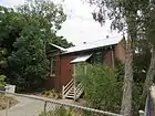 | |
| Sewerage Vent, Shenton Park | 24815 | Gray Street | Shenton Park | 31°57′24″S 115°48′30″E / 31.956705°S 115.808469°E | Part of Metropolitan Sewerage Vents (23992 ) |  | |
| Subiaco Oval Playing Field (excludes stands and surrounds) | 25371 | 304 | Roberts Road | Subiaco | 31°56′40″S 115°49′48″E / 31.944444°S 115.830000°E |  |
Notes
References
- ↑ "City of Subiaco Heritage Places". inherit.stateheritage.wa.gov.au. Heritage Council of Western Australia. Retrieved 18 January 2023.
- ↑ "City of Subiaco State Register of Heritage Places". inherit.stateheritage.wa.gov.au. Heritage Council of Western Australia. Retrieved 18 January 2023.
This article is issued from Wikipedia. The text is licensed under Creative Commons - Attribution - Sharealike. Additional terms may apply for the media files.