The State Register of Heritage Places is maintained by the Heritage Council of Western Australia. As of 2023, 225 places are heritage-listed in the City of Busselton,[1] of which 33 are on the State Register of Heritage Places.[2]
List
The Western Australian State Register of Heritage Places, as of 2023, lists the following 33 state registered places within the City of Busselton:
| Place name | Place # | Street number | Street name | Suburb or town | Co-ordinates | Notes & former names | Photo |
|---|---|---|---|---|---|---|---|
| Bovell's Cottage | 385 | 13 | Adelaide Street | Busselton | 33°38′52″S 115°20′34″E / 33.647756°S 115.342738°E |  | |
| Villa Carlotta | 386 | 110 | Adelaide Street | Busselton | 33°38′46″S 115°21′14″E / 33.646078°S 115.354027°E | St Joseph's Convent and School (former), Ithaca |  |
| Prospect Villa | 389 | 4 & 4A | Pries Avenue | Busselton | 33°39′10″S 115°20′40″E / 33.65273°S 115.34434°E |  | |
| Sandilands | 394 | Layman Road, north-east of intersection with Ford Road | Geographe | 33°38′49″S 115°21′41″E / 33.647068°S 115.361435°E | |||
| Bond Store & Resident Magistrate's Office (former), Busselton | 395 | 22 | Kent Street | West Busselton | 33°39′04″S 115°20′27″E / 33.651019°S 115.340864°E | Bond Store & Custom Officer's Residence, The Gulch, Police Residence | |
| Busselton Court House and Police Complex | 401 | 4 | Queen Street | Busselton | 33°38′50″S 115°20′36″E / 33.647137°S 115.343224°E | Old Court House & Police Complex Precinct | 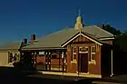 |
| St Mary's Anglican Church and Graveyard | 402 | 39 | Peel Terrace | Busselton | 33°39′10″S 115°20′44″E / 33.65276°S 115.345687°E | Hall site, includes: Church, Graveyard, Rectory | .jpg.webp) |
| Weld Hall Theatre | 404 | 13 | Queen Street | Busselton | 33°38′51″S 115°20′39″E / 33.647555°S 115.344133°E | Weld Repertory Theatre, Weld Institute, Weld Mechanics' Institute | 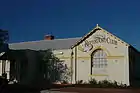 |
| Office of the Department of Agriculture | 405 | 7 | Queen Street | Busselton | 33°38′49″S 115°20′38″E / 33.646923°S 115.343945°E | Agricultural Bank of Western Australia, Agriculture Western Australia, ArtGeo Gallery | .jpg.webp) |
| Old Busselton Cemetery | 406 | Stanley Street, corner Adelaide Street & Marine Tce | Busselton | 33°38′49″S 115°20′38″E / 33.646923°S 115.343945°E | Burial Ground, Pioneer Cemetery, Marine Terrace Cemetery | 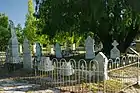 | |
| Old Vasse Primary School Precinct | 418 | 21 | Kaloorup Road | Vasse | 33°40′45″S 115°14′59″E / 33.679283°S 115.249772°E | Old Vasse School | .JPG.webp) |
| Chapman's Mill (Inlet Park farm) | 421 | 71 | Tall Tree Crescent | Reinscourt | 33°38′48″S 115°24′51″E / 33.646797°S 115.414272°E | ||
| Busselton Jetty | 423 | 2 | Queen Street | Busselton | 33°38′13″S 115°20′24″E / 33.6369°S 115.3401°E | _(5345722138).jpg.webp) | |
| Wonnerup Precinct | 424 | 935 & 936 | Layman Road | Wonnerup | 33°37′39″S 115°25′58″E / 33.6276°S 115.4328°E | Wonnerup House and Grounds | 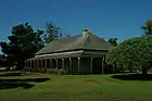 |
| Wonnerup School & Teacher's House | 425 | 936 | Layman Road | Wonnerup | 33°37′39″S 115°25′58″E / 33.6276°S 115.4328°E | Old Wonnerup School & Teacher's House | 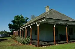 |
| Abbey Farm | 426 | 57 | Abbeys Farm Road | Yallingup | 33°43′03″S 115°02′17″E / 33.717587°S 115.038137°E | ||
| Caves House | 428 | Yallingup Beach Road | Yallingup | 33°38′44″S 115°01′51″E / 33.64542°S 115.030935°E | Caves House Yallingup, Yallingup Caves Accommodation House |  | |
| Millbrook Farm | 429 | Millbrook Road | Yallingup | 33°40′38″S 115°02′50″E / 33.67712°S 115.047091°E | Millbrook Mill & Limekiln |  | |
| Cape Naturaliste Lighthouse and Quarters | 2914 | Cape Naturaliste Road | Cape Naturaliste | 33°32′14″S 115°01′07″E / 33.537333°S 115.018694°E |  | ||
| St Davitt's | 2936 | 27 | Georgette Street | Busselton | 33°38′49″S 115°21′22″E / 33.647019°S 115.356146°E | Early Cammilleri Residence | |
| Slab Cottage Group, Quindalup | 3478 | 1087 | Caves Road | Busselton | 33°38′08″S 115°08′47″E / 33.635634°S 115.146318°E | Old Quindalup Post Office (former), Harwood's Cottage Cafe, Harwoods Beach Station (former), Inlet Villa, Slab Cottage, Harwood's Cafe & Quindalup Post Office | |
| Old Butter Factory | 3568 | 76 | Peel Terrace | Busselton | 33°39′10″S 115°20′59″E / 33.652703°S 115.34986°E | Old Butter Factory / Museum, Busselton Butter Factory (former) | _(5345114621).jpg.webp) |
| Lady Campion Hostel (former) | 5299 | 27 | Adelaide Street | Busselton | 33°38′51″S 115°20′40″E / 33.647488°S 115.34445°E | 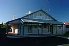 | |
| Old Busselton Post Office Site & Post Box † | 5304 | 20 | Queen Street | Busselton | 33°38′53″S 115°20′37″E / 33.648093°S 115.343618°E | ||
| Ballarat Tramline Plaque and Wheel (Locomotive) | 5333 | Ruabon Road | Wonnerup | 33°37′37″S 115°25′58″E / 33.626984°S 115.4327071°E | |||
| Cattle Chosen | 5337 | 12 | Drovers Road | Bovell | 33°40′26″S 115°21′31″E / 33.673764°S 115.358564°E | ||
| Westbrook Homestead | 5372 | 24 | Westbrook Glen | Vasse | 33°41′33″S 115°14′12″E / 33.692376°S 115.236724°E | ||
| Ludlow Forestry Mill and Settlement | 15834 | Corner Ludlow Road North & Tuart Drive | Ludlow | 33°36′00″S 115°28′00″E / 33.600000°S 115.466667°E | Ludlow Forestry Settlement | 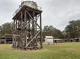 | |
| Site of Ballarat Bridge, Vasse Floodgates & Wonnerup Floodgates † | 16727 | Layman Road | Wonnerup | 33°36′49″S 115°25′33″E / 33.6135°S 115.425834°E | Wonnerup Wetlands | ||
| St Mary's Church hall - site | 18162 | Queen Street, corner Albert Street | Busselton | 33°39′08″S 115°20′44″E / 33.652346°S 115.345563°E | Church, Graveyard, Rectory & Hall site | ||
| St Mary's Church Rectory | 18163 | 41 | Peel Terrace | Busselton | 33°39′10″S 115°20′46″E / 33.652653°S 115.346195°E | & Graveyard, Rectory and Hall site, part of St Mary's Anglican Church | 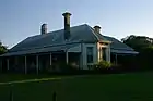 |
| Millbrook Water Mill | 18179 | Millbrook Road | Yallingup | 33°40′39″S 115°02′47″E / 33.67763°S 115.046348°E | |||
| Red Post Boxes Group | 25501 | Kalgoorlie, Busselton, Bassendean | 33°38′53″S 115°20′38″E / 33.647992°S 115.343818°E | 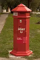 |
- † Denotes structure or building has been demolished
References
- ↑ "City of Busselton Heritage Places". inherit.stateheritage.wa.gov.au. Heritage Council of Western Australia. Retrieved 25 February 2023.
- ↑ "City of Busselton State Register of Heritage Places". inherit.stateheritage.wa.gov.au. Heritage Council of Western Australia. Retrieved 25 February 2023.
This article is issued from Wikipedia. The text is licensed under Creative Commons - Attribution - Sharealike. Additional terms may apply for the media files.