The State Register of Heritage Places is maintained by the Heritage Council of Western Australia. As of 2023, 193 places are heritage-listed in the City of Gosnells,[1] of which six are on the State Register of Heritage Places.[2]
List
The Western Australian State Register of Heritage Places, as of 2023, lists the following six state registered places within the City of Gosnells:
| Place name | Place # | Location | Suburb or town | Co-ordinates | Built | Stateregistered | Notes | Photo |
|---|---|---|---|---|---|---|---|---|
| Wilkinson Homestead | 1127 | Lot 101 Homestead Road | Gosnells | 32°03′50″S 115°58′56″E / 32.06389°S 115.98222°E | 1912 | 26 February 1999 |
|
 |
| Maddington Homestead | 1132 | Burslem Drive | Maddington | 32°03′27″S 115°58′43″E / 32.05750°S 115.97861°E | 1836 | 21 September 2001 |
|
 |
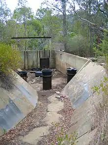
| Canning Contour Channel (former) | 3709 | Lot 50 Canning Mills Road | Kelmscott | 32°07′23″S 116°04′57″E / 32.12306°S 116.08250°E | 1935 | 3 June 2005 |
|
 |
| Arum Lilies, John Okey Davis Park | 13809 | Burslem Bridge, Burslem Drive | Gosnells | 32°03′50″S 115°58′56″E / 32.06389°S 115.98222°E |
|
|||
| John Okey Davis Park | 13817 | Homestead Road | Gosnells | 32°03′50″S 115°58′56″E / 32.06389°S 115.98222°E |
|
 | ||
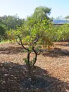
| Wilkinson's Orchard (former) (Almond Trees, Jarrah Tree, John Okey Davis Park) | 13830 | Homestead Road | Gosnells | 32°03′50″S 115°58′56″E / 32.06389°S 115.98222°E |
|
 |
References
- ↑ "City of Gosnells Heritage Places". inherit.stateheritage.wa.gov.au. Heritage Council of Western Australia. Retrieved 17 February 2023.
- ↑ "City of Gosnells State Register of Heritage Places". inherit.stateheritage.wa.gov.au. Heritage Council of Western Australia. Retrieved 17 February 2023.
This article is issued from Wikipedia. The text is licensed under Creative Commons - Attribution - Sharealike. Additional terms may apply for the media files.