Location of Oglethorpe County in Georgia
This is a list of properties and districts in Oglethorpe County, Georgia that are listed on the National Register of Historic Places (NRHP).
This National Park Service list is complete through NPS recent listings posted January 12, 2024.[1]

Current listings
| [2] | Name on the Register | Image | Date listed[3] | Location | City or town | Description |
|---|---|---|---|---|---|---|
| 1 | Amis-Elder House |  Amis-Elder House |
August 2, 1978 (#78000997) |
W of Crawford on Elder Rd. 33°49′04″N 83°15′55″W / 33.817778°N 83.265278°W |
Crawford | |
| 2 | J. L. Bridges Home Place | January 31, 1978 (#78000999) |
N of Lexington on GA 22 33°56′04″N 83°01′28″W / 33.934444°N 83.024444°W |
Lexington | ||
| 3 | Crawford Depot | 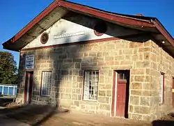 Crawford Depot |
May 27, 1977 (#77000441) |
U.S. 78 33°52′57″N 83°09′22″W / 33.8825°N 83.156111°W |
Crawford | |
| 4 | Durham Place |  Durham Place |
June 5, 2017 (#100001020) |
261 N. Main St. 33°45′24″N 83°10′28″W / 33.756745°N 83.174515°W |
Maxeys | |
| 5 | Faust Houses and Outbuildings | February 12, 1980 (#80001217) |
NE of Lexington off GA 77 33°53′46″N 83°00′56″W / 33.896111°N 83.015556°W |
Lexington | Buildings and house no longer exist | |
| 6 | Howard's Covered Bridge |  Howard's Covered Bridge |
July 1, 1975 (#75000604) |
3 mi. SE of Smithonia on SR S2164 over Big Clouds Creek 33°59′09″N 83°08′01″W / 33.985833°N 83.133611°W |
Smithonia | |
| 7 | Langston-Daniel House | 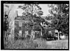 Langston-Daniel House |
January 31, 1978 (#78000998) |
5 mi. (8 km) W of Crawford on U.S. 78 33°53′45″N 83°13′03″W / 33.895833°N 83.2175°W |
Crawford | |
| 8 | Lexington Historic District | 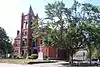 Lexington Historic District |
April 13, 1977 (#77000442) |
U.S. 78 33°52′16″N 83°06′36″W / 33.871111°N 83.11°W |
Lexington | |
| 9 | Maxeys Historic District | September 2, 2022 (#100008047) |
Area surrounding GA 77 (Main St. or Union Point Rd.) 33°45′17″N 83°10′26″W / 33.7546°N 83.1739°W |
Maxeys | ||
| 10 | Philomath Historic District |  Philomath Historic District |
July 6, 1979 (#79000740) |
GA 22 33°43′19″N 82°59′01″W / 33.721944°N 82.983611°W |
Philomath | |
| 11 | Smith-Harris House | July 25, 1985 (#85001620) |
CR 207 33°56′57″N 82°57′41″W / 33.949167°N 82.961389°W |
Vesta | ||
| 12 | Smithonia | 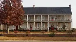 Smithonia |
June 21, 1984 (#84001213) |
Address Restricted |
Comer | |
| 12 | Watson Mill Covered Bridge and Mill Historic District | 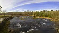 Watson Mill Covered Bridge and Mill Historic District |
September 5, 1991 (#91001147) |
Along S. Fork Broad R., Watson Mill State Park 34°01′34″N 83°04′23″W / 34.026111°N 83.073056°W |
Comer |
References
Wikimedia Commons has media related to National Register of Historic Places in Oglethorpe County, Georgia.
- ↑ National Park Service, United States Department of the Interior, "National Register of Historic Places: Weekly List Actions", retrieved January 12, 2024.
- ↑ Numbers represent an alphabetical ordering by significant words. Various colorings, defined here, differentiate National Historic Landmarks and historic districts from other NRHP buildings, structures, sites or objects.
- ↑ The eight-digit number below each date is the number assigned to each location in the National Register Information System database, which can be viewed by clicking the number.
| Topics | |
|---|---|
| Lists by state |
|
| Lists by insular areas | |
| Lists by associated state | |
| Other areas | |
| Related | |
This article is issued from Wikipedia. The text is licensed under Creative Commons - Attribution - Sharealike. Additional terms may apply for the media files.