
Location of Gwinnett County in Georgia
This is a list of properties and districts in Gwinnett County, Georgia that are listed on the National Register of Historic Places (NRHP).
This National Park Service list is complete through NPS recent listings posted January 12, 2024.[1]

Current listings
| [2] | Name on the Register | Image | Date listed[3] | Location | City or town | Description |
|---|---|---|---|---|---|---|
| 1 | Alcovy Road Grist Mill | 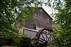 Alcovy Road Grist Mill |
July 23, 1998 (#98000885) |
1564 Alcovy Rd. 33°57′46″N 83°55′35″W / 33.962778°N 83.926389°W |
Dacula | |
| 2 | Bona Allen House |  Bona Allen House |
September 1, 1983 (#83000231) |
395 Main St. 34°07′25″N 84°00′01″W / 34.123611°N 84.000278°W |
Buford | |
| 3 | John Quincy Allen House | 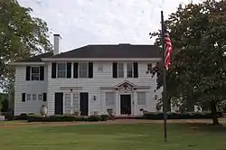 John Quincy Allen House |
January 12, 1984 (#84001109) |
345 E. Main St. 34°07′21″N 84°00′04″W / 34.1225°N 84.001111°W |
Buford | |
| 4 | Bona Allen Shoe and Horse Collar Factory | 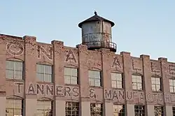 Bona Allen Shoe and Horse Collar Factory |
January 3, 2005 (#04001138) |
554 W. Main St. 34°06′50″N 84°00′43″W / 34.113889°N 84.011944°W |
Buford | |
| 5 | Buford Public School Auditorium | August 5, 2009 (#09000586) |
4975 Little Mill Rd. 34°07′10″N 84°00′38″W / 34.119467°N 84.010433°W |
Buford | ||
| 6 | Robert Craig Plantation | 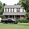 Robert Craig Plantation |
June 8, 1990 (#90000805) |
1504 Five Forks Trickum Rd. 33°54′24″N 84°00′59″W / 33.906667°N 84.016389°W |
Lawrenceville | |
| 7 | Gwinnett County Courthouse | 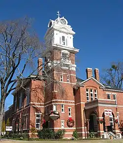 Gwinnett County Courthouse |
September 18, 1980 (#80001084) |
Courthouse Sq. 33°57′24″N 83°59′21″W / 33.956667°N 83.989167°W |
Lawrenceville | |
| 8 | Mechanicsville School | 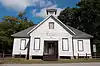 Mechanicsville School |
October 16, 1980 (#80001085) |
3980 Florida Ave. Northwest 33°55′43″N 84°14′50″W / 33.928611°N 84.247222°W |
Peachtree Corners | Formerly located in unincorporated Gwinnett County (near Norcross), now within the city limits of Peachtree Corners. The building is typical of early 20th Century rural schoolhouse architecture. The school was a fixture of the Mechanicsville community in the early 1900s. |
| 9 | Norcross Historic District |  Norcross Historic District |
November 21, 1980 (#80001086) |
Off U.S. 23 33°56′33″N 84°12′44″W / 33.9425°N 84.212222°W |
Norcross | |
| 10 | Old Seminary Building | 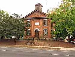 Old Seminary Building |
December 29, 1970 (#70000206) |
455 Perry St. 33°57′09″N 83°59′20″W / 33.9525°N 83.9890°W |
Lawrenceville | |
| 11 | Parks-Strickland Archeological Complex | 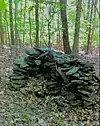 Parks-Strickland Archeological Complex |
December 8, 1989 (#89002034) |
Little Mulberry Park 34°02′29″N 83°53′04″W / 34.0413°N 83.884511°W |
Dacula | |
| 12 | The Superb | 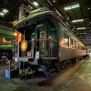 The Superb |
March 9, 1999 (#98001560) |
3595 S. Old Peachtree Rd. 33°59′19″N 84°09′20″W / 33.988611°N 84.155556°W |
Duluth | Railroad car that was used by U.S. President Harding |
| 13 | Suwanee Historic District | 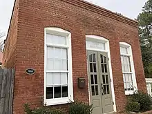 Suwanee Historic District |
December 24, 2013 (#13000966) |
Main, Russell & White Sts., Stonecypher & Scales Rds., N & S Railroad 34°03′10″N 84°04′27″W / 34.052819°N 84.074228°W |
Suwanee | |
| 14 | William Terrell Homeplace | August 26, 1982 (#82002423) |
E of Lawrenceville off US 29 33°57′59″N 83°57′58″W / 33.966389°N 83.966111°W |
Lawrenceville | ||
| 15 | Clarence R. Ware House | 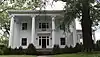 Clarence R. Ware House |
June 17, 1982 (#82002424) |
293 N. Perry St. 33°57′30″N 83°59′25″W / 33.958333°N 83.990278°W |
Lawrenceville | |
| 16 | Elisha Winn House | 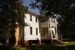 Elisha Winn House |
December 18, 1979 (#79000728) |
N of Dacula at 908 Dacula Rd. 34°01′24″N 83°54′30″W / 34.02345°N 83.90821°W |
Dacula | |
| 17 | Thomas Wynne House | 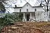 Thomas Wynne House |
July 8, 1977 (#77000436) |
N of Lilburn on U.S. 29 33°53′57″N 84°08′17″W / 33.899167°N 84.138056°W |
Lilburn |
Former listings
| [2] | Name on the Register | Image | Date listed | Date removed | Location | City or town | Description |
|---|---|---|---|---|---|---|---|
| 1 | Isaac Adair House |  Isaac Adair House |
November 29, 2000 (#00001390) | February 6, 2020 | 15 S Clayton St 33°55′31″N 83°57′20″W / 33.925278°N 83.955556°W |
Lawrenceville | Relocated to its current location in 2008 due to construction of the Sugarloaf Parkway through its previous location. |
| 2 | Hudson-Nash House and Cemetery | 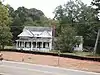 Hudson-Nash House and Cemetery |
January 4, 1990 (#89002264) | April 26, 2019 | 3490 Five Forks Trickum Rd. 33°52′29″N 84°04′21″W / 33.874722°N 84.0725°W |
Lilburn | Delisted due to relocation to Yellow River Post Office Park. |
See also
Wikimedia Commons has media related to National Register of Historic Places in Gwinnett County, Georgia.
References
- ↑ National Park Service, United States Department of the Interior, "National Register of Historic Places: Weekly List Actions", retrieved January 12, 2024.
- 1 2 Numbers represent an alphabetical ordering by significant words. Various colorings, defined here, differentiate National Historic Landmarks and historic districts from other NRHP buildings, structures, sites or objects.
- ↑ The eight-digit number below each date is the number assigned to each location in the National Register Information System database, which can be viewed by clicking the number.
| Topics | |
|---|---|
| Lists by state |
|
| Lists by insular areas | |
| Lists by associated state | |
| Other areas | |
| Related | |
This article is issued from Wikipedia. The text is licensed under Creative Commons - Attribution - Sharealike. Additional terms may apply for the media files.