This is a list of properties and districts in Newton County, Georgia that are listed on the National Register of Historic Places (NRHP).
This National Park Service list is complete through NPS recent listings posted December 22, 2023.[1]

Current listings
| [2] | Name on the Register | Image | Date listed[3] | Location | City or town | Description |
|---|---|---|---|---|---|---|
| 1 | Brick Store | 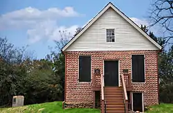 Brick Store |
April 9, 2009 (#09000186) |
U.S. Route 278 at Old Social Circle Road 33°36′07″N 83°44′42″W / 33.601806°N 83.745°W |
Covington | |
| 2 | Burge Farm |  Burge Farm |
May 11, 2000 (#00000467) |
Roughly bounded by GA 142, Cook Rd., Morehouse Rd. and Sewell Rd. 33°32′47″N 83°43′47″W / 33.54629°N 83.72962°W |
Newborn | |
| 3 | Covington Historic District | August 6, 1998 (#98000969) |
Roughly Covington City S of US 278 33°35′41″N 83°51′12″W / 33.594722°N 83.853333°W |
Covington | ||
| 4 | Covington Mills and Mill Village Historic District | April 14, 2000 (#00000370) |
Roughly bounded by Wheat, Collins and Lott Sts. and, to the north, the Covington Mills pond and Creek 33°36′19″N 83°50′50″W / 33.605278°N 83.847222°W |
Covington | ||
| 5 | Floyd Street Historic District | December 4, 1974 (#74000699) |
Floyd St. from Elm to W of Sockwell St. 33°35′48″N 83°51′20″W / 33.596667°N 83.855556°W |
Covington | ||
| 6 | Newborn Historic District | August 6, 1998 (#98000970) |
Roughly the entire city limits of Newborn City 33°31′09″N 83°41′45″W / 33.519167°N 83.695833°W |
Newborn | ||
| 7 | Newton County Courthouse | 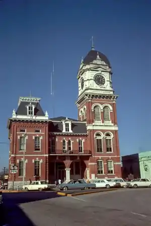 Newton County Courthouse |
September 18, 1980 (#80001216) |
Courthouse Sq. 33°35′49″N 83°51′37″W / 33.596944°N 83.860278°W |
Covington | |
| 8 | North Covington Historic District | May 26, 2000 (#00000526) |
N. Emory and Odum Sts. and Georgia (CSX) Railroad 33°36′26″N 83°51′48″W / 33.607222°N 83.863333°W |
Covington | ||
| 9 | Orna Villa |  Orna Villa |
January 29, 1973 (#73000636) |
1008 N. Emory St. 33°37′27″N 83°51′59″W / 33.62408°N 83.86641°W |
Oxford | |
| 10 | Oxford Historic District |  Oxford Historic District |
June 5, 1975 (#75000603) |
College and residential district centered around Wesley St. 33°37′32″N 83°52′13″W / 33.625556°N 83.870278°W |
Oxford | |
| 11 | Porterdale Historic District | September 17, 2001 (#01000974) |
Roughly the city limits of Porterdale north of Elm St. 33°34′23″N 83°53′45″W / 33.573056°N 83.895833°W |
Porterdale | ||
| 12 | Salem Camp Ground | 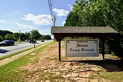 Salem Camp Ground |
March 5, 1998 (#98000175) |
3940 Salem Rd. 33°35′09″N 83°58′00″W / 33.58576°N 83.9667°W |
Covington | |
| 13 | Starrsville Historic District | June 26, 1998 (#98000715) |
Jct. GA 213, Old Starsville and Dixie Rds. 33°31′44″N 83°48′35″W / 33.528889°N 83.809722°W |
Starrsville |
References
- ↑ National Park Service, United States Department of the Interior, "National Register of Historic Places: Weekly List Actions", retrieved December 22, 2023.
- ↑ Numbers represent an alphabetical ordering by significant words. Various colorings, defined here, differentiate National Historic Landmarks and historic districts from other NRHP buildings, structures, sites or objects.
- ↑ The eight-digit number below each date is the number assigned to each location in the National Register Information System database, which can be viewed by clicking the number.
Wikimedia Commons has media related to National Register of Historic Places in Newton County, Georgia.
| Topics | |
|---|---|
| Lists by state |
|
| Lists by insular areas | |
| Lists by associated state | |
| Other areas | |
| Related | |
This article is issued from Wikipedia. The text is licensed under Creative Commons - Attribution - Sharealike. Additional terms may apply for the media files.