Takestan County
Persian: شهرستان تاکستان | |
|---|---|
County | |
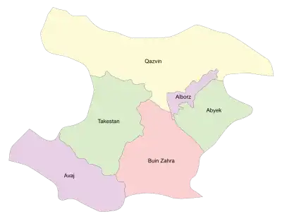 Location of Takestan County in Qazvin province (left, green) | |
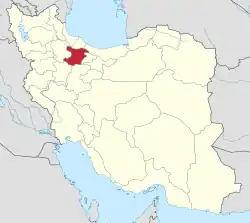 Location of Qazvin province in Iran | |
| Coordinates: 36°01′N 49°30′E / 36.017°N 49.500°E[1] | |
| Country | |
| Province | Qazvin |
| Capital | Takestan |
| Districts | Central, Esfarvarin, Khorramdasht, Ziaabad |
| Population (2016)[2] | |
| • Total | 172,636 |
| Time zone | UTC+3:30 (IRST) |
| Takestan County at GEOnet Names Server | |
Takestan County (Persian: شهرستان تاکستان, shahrestan-e Takestan ,Tati:Šareston-e Tâkestân ) is in Qazvin province, Iran. Its capital is the city of Takestan.[3]
At the 2006 census, the county's population was 171,520 in 42,969 households.[4] The following census in 2011 counted 172,949 people in 50,247 households.[5] At the 2016 census, the county's population was 172,636 in 52,917 households.[2] Most people of Takestan County are Tat and they speak Tati.[6][7][8][9]
Administrative divisions
The population history of Takestan County's administrative divisions over three consecutive censuses is shown in the following table. The latest census shows four districts, nine rural districts, and five cities.[2]
| Administrative Divisions | 2006[4] | 2011[5] | 2016[2] |
|---|---|---|---|
| Central District | 99,841 | 102,401 | 103,757 |
| Narjeh RD | 923 | 739 | 555 |
| Qaqazan-e Gharbi RD | 7,332 | 6,057 | 4,412 |
| Qaqazan-e Sharqi RD | 12,890 | 12,294 | 12,887 |
| Narjeh (city) | 5,071 | 5,404 | 5,604 |
| Takestan (city) | 73,625 | 77,907 | 80,299 |
| Esfarvarin District | 28,845 | 29,106 | 29,300 |
| Ak RD | 10,282 | 9,880 | 10,320 |
| Khorramabad RD | 6,459 | 6,611 | 6,609 |
| Esfarvarin (city) | 12,104 | 12,615 | 12,371 |
| Khorramdasht District | 21,685 | 21,910 | 20,661 |
| Afshariyeh RD | 8,549 | 7,947 | 7,262 |
| Ramand-e Shomali RD | 6,944 | 7,238 | 6,845 |
| Khorramdasht (city) | 6,192 | 6,725 | 6,554 |
| Ziaabad District | 21,149 | 19,532 | 18,918 |
| Dodangeh-ye Olya RD | 6,002 | 4,898 | 5,061 |
| Dodangeh-ye Sofla RD | 6,762 | 5,997 | 5,595 |
| Ziaabad (city) | 8,385 | 8,637 | 8,262 |
| Total | 171,520 | 172,949 | 172,636 |
| RD: Rural District | |||
Wikimedia Commons has media related to Takestan County.
References
- ↑ OpenStreetMap contributors (17 May 2023). "Takestan County" (Map). OpenStreetMap. Retrieved 17 May 2023.
- 1 2 3 4 "Census of the Islamic Republic of Iran, 1395 (2016)". AMAR (in Persian). The Statistical Center of Iran. p. 26. Archived from the original (Excel) on 30 November 2021. Retrieved 19 December 2022.
- ↑ Habibi, Hassan (7 July 1369). "Approval of the organization and chain of citizenship of elements and units of country divisions of Zanjan province, centered in Zanjan city". Lamtakam (in Persian). Ministry of Interior, Defense Political Commission of the Government Council. Archived from the original on 16 December 2023. Retrieved 16 December 2023.
- 1 2 "Census of the Islamic Republic of Iran, 1385 (2006)". AMAR (in Persian). The Statistical Center of Iran. p. 26. Archived from the original (Excel) on 20 September 2011. Retrieved 25 September 2022.
- 1 2 "Census of the Islamic Republic of Iran, 1390 (2011)". Syracuse University (in Persian). The Statistical Center of Iran. p. 26. Archived from the original (Excel) on 19 January 2023. Retrieved 19 December 2022.
- ↑ The Tati dialects in the Sociolinguistic Context of Northwestern Iran and Transcaucasia, Stilo, D. 1981: In: Iranian Studies 14.3/4, 137-187.
- ↑ A Grammar of Southern Tati Dialects, Ehsan Yar-Shater, 1969.
- ↑ Tats of Iran and Caucasus, Ali Abdoli, 2010.
- ↑ "Ethnologue: Languages of the World".
Qazvin Province, Iran | |||||||||||||
|---|---|---|---|---|---|---|---|---|---|---|---|---|---|
| Capital |  | ||||||||||||
| Counties and cities |
| ||||||||||||
| Sights | |||||||||||||
| populated places | |||||||||||||
| Capital | |||||||||||||||||||||||||||||||||||||||||||
|---|---|---|---|---|---|---|---|---|---|---|---|---|---|---|---|---|---|---|---|---|---|---|---|---|---|---|---|---|---|---|---|---|---|---|---|---|---|---|---|---|---|---|---|
| Districts |
| ||||||||||||||||||||||||||||||||||||||||||
This article is issued from Wikipedia. The text is licensed under Creative Commons - Attribution - Sharealike. Additional terms may apply for the media files.