
This is a list of the National Register of Historic Places listings in Mora County, New Mexico.
This is intended to be a complete list of the properties and districts on the National Register of Historic Places in Mora County, New Mexico, United States. Latitude and longitude coordinates are provided for many National Register properties and districts; these locations may be seen together in a map.[1]
There are 23 properties and districts listed on the National Register in the county, including 2 National Historic Landmarks. All of the places within the county on the National Register are also listed on the State Register of Cultural Properties.
This National Park Service list is complete through NPS recent listings posted January 12, 2024.[2]
| Bernalillo – Catron – Chaves – Cibola – Colfax – Curry – De Baca – Doña Ana – Eddy – Grant – Guadalupe – Harding – Hidalgo – Lea – Lincoln – Los Alamos – Luna – McKinley – Mora – Otero – Quay – Rio Arriba – Roosevelt – San Juan – San Miguel – Sandoval – Santa Fe – Sierra – Socorro – Taos – Torrance – Union – Valencia |
Current listings
| [3] | Name on the Register[4] | Image | Date listed[5] | Location | City or town | Description |
|---|---|---|---|---|---|---|
| 1 | Cassidy Mill | 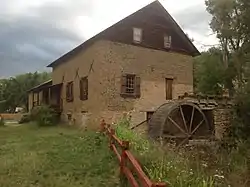 Cassidy Mill |
December 6, 1978 (#78001818) |
Southeast of Cleveland off State Road 3 35°59′08″N 105°21′29″W / 35.985556°N 105.358056°W |
Cleveland | |
| 2 | Daniel Cassidy and Sons General Merchandise Store | .jpg.webp) Daniel Cassidy and Sons General Merchandise Store |
August 1, 1979 (#79001541) |
State Road 3 35°59′41″N 105°22′16″W / 35.994722°N 105.371111°W |
Cleveland | |
| 3 | Daniel Cassidy House |  Daniel Cassidy House |
July 27, 1990 (#90001062) |
Address Restricted |
Mora | |
| 4 | James J. Cassidy House | James J. Cassidy House |
September 1, 2005 (#05000943) |
Address Restricted |
Cleveland | |
| 5 | Fort Union National Monument | 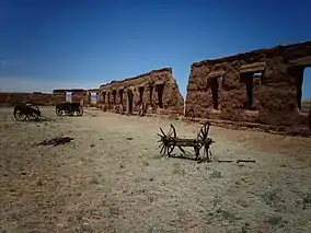 Fort Union National Monument |
October 15, 1966 (#66000044) |
9 miles north of Watrous on State Road 477 35°54′26″N 105°01′06″W / 35.907222°N 105.018333°W |
Watrous | |
| 6 | Garcia House | Garcia House |
December 24, 1990 (#90001063) |
Address Restricted |
Mora | |
| 7 | Gordon-Sanchez Mill | Gordon-Sanchez Mill |
July 27, 1990 (#90001061) |
Address Restricted |
Mora | |
| 8 | Guadalupita-Coyote Rural Historic District | June 5, 2017 (#100001034) |
Village of Guadalupita, parts of Guadalupita and Williams canyons, and the Coyote Creek valley between Guadalupita and Lucero 36°08′17″N 105°14′17″W / 36.138°N 105.238°W |
Guadalupita | ||
| 9 | La Cueva Historic District | La Cueva Historic District |
May 25, 1973 (#73001144) |
6 miles southeast of Mora at the junction of State Roads 3 and 21 35°56′34″N 105°14′51″W / 35.942778°N 105.2475°W |
Mora | |
| 10 | Ledoux Rural Historic District | Ledoux Rural Historic District |
December 24, 1990 (#90001057) |
Address Restricted |
Ledoux | |
| 11 | Mora Historic District | Mora Historic District |
December 24, 1990 (#90001056) |
Address Restricted |
Mora | |
| 12 | North Carmen Historic District | North Carmen Historic District |
December 24, 1990 (#90001058) |
Address Restricted |
Ledoux | |
| 13 | Ocate Creek Crossing and the Santa Fe Trail-Mora County Trail Segments | April 21, 1994 (#94000329) |
1.75 miles north of the junction of State Road 127 and the road to Mora Ranch 36°09′02″N 104°54′03″W / 36.150556°N 104.900833°W |
Ocate | ||
| 14 | Jose Olquin Barn-Corral Complex | Jose Olquin Barn-Corral Complex |
December 24, 1990 (#90001060) |
Address Restricted |
Mora | |
| 15 | Santa Clara Hotel | 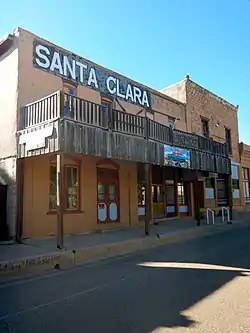 Santa Clara Hotel |
May 16, 1991 (#91000602) |
111 Railroad Ave. 36°00′30″N 104°42′22″W / 36.008333°N 104.706111°W |
Wagon Mound | |
| 16 | St. Vrain's Mill | 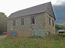 St. Vrain's Mill |
August 28, 1973 (#73001143) |
On State Road 38 35°58′32″N 105°19′44″W / 35.975556°N 105.328889°W |
Mora | |
| 17 | J. P. Strong Store | 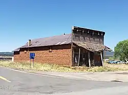 J. P. Strong Store |
July 27, 1979 (#79001542) |
State Roads 120 and 442 36°10′31″N 105°02′55″W / 36.175315°N 105.048666°W |
Ocate | An excellent example of a crossroads general store in the southwest |
| 18 | Tipton-Black Willow Ranch Historic District | June 29, 2001 (#00001287) |
3 miles east of Watrous 35°47′28″N 104°55′34″W / 35.791111°N 104.926111°W |
Watrous | ||
| 19 | Desiderio Valdez House | Desiderio Valdez House |
December 24, 1990 (#90001059) |
Address Restricted |
Cleveland | |
| 20 | Narciso Valdez House | 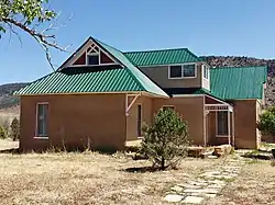 Narciso Valdez House |
July 11, 1980 (#80004484) |
State Road 120 36°10′34″N 105°02′55″W / 36.176116°N 105.048482°W |
Ocate | Adobe house with Queen Anne style, particularly in its interior. |
| 21 | Valmora Sanatorium Historic District | March 23, 1995 (#95000286) |
State Road 97, 4 miles east of its junction with State Road 161, northeast of Watrous 35°49′01″N 104°55′27″W / 35.817081°N 104.924119°W |
Watrous | Hospital (1920) and eight other buildings of historic cottage-plan tuberculosis sanatorium. | |
| 22 | Wagon Mound |  Wagon Mound |
October 15, 1966 (#66000478) |
East of Wagon Mound on U.S. Route 85 36°00′39″N 104°42′10″W / 36.010833°N 104.702778°W |
Wagon Mound | |
| 23 | Watrous | .jpg.webp) Watrous |
October 15, 1966 (#66000480) |
U.S. Route 85 35°48′03″N 105°00′05″W / 35.800833°N 105.001389°W |
Watrous |
See also
References
- ↑ The latitude and longitude information provided in this table was derived originally from the National Register Information System, which has been found to be fairly accurate for about 99% of listings. Some locations in this table may have been corrected to current GPS standards.
- ↑ National Park Service, United States Department of the Interior, "National Register of Historic Places: Weekly List Actions", retrieved January 12, 2024.
- ↑ Numbers represent an alphabetical ordering by significant words. Various colorings, defined here, differentiate National Historic Landmarks and historic districts from other NRHP buildings, structures, sites or objects.
- ↑ "National Register Information System". National Register of Historic Places. National Park Service. April 24, 2008.
- ↑ The eight-digit number below each date is the number assigned to each location in the National Register Information System database, which can be viewed by clicking the number.
| Topics | |
|---|---|
| Lists by state |
|
| Lists by insular areas | |
| Lists by associated state | |
| Other areas | |
| Related | |
Municipalities and communities of Mora County, New Mexico, United States | ||
|---|---|---|
| Village | Map of New Mexico highlighting Mora County | |
| CDPs | ||
| Other unincorporated communities | ||