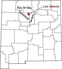
Location of Los Alamos County in New Mexico
This is a list of the National Register of Historic Places listings in Los Alamos County, New Mexico.
This is intended to be a complete list of the properties and districts on the National Register of Historic Places in Los Alamos County, New Mexico, United States. Latitude and longitude coordinates are provided for many National Register properties and districts; these locations may be seen together in a map.[1]
There are 13 properties and districts listed on the National Register in the county, including 2 National Historic Landmarks. Eight of these sites are also recorded on the State Register of Cultural Properties.
This National Park Service list is complete through NPS recent listings posted January 12, 2024.[2]
| Bernalillo – Catron – Chaves – Cibola – Colfax – Curry – De Baca – Doña Ana – Eddy – Grant – Guadalupe – Harding – Hidalgo – Lea – Lincoln – Los Alamos – Luna – McKinley – Mora – Otero – Quay – Rio Arriba – Roosevelt – San Juan – San Miguel – Sandoval – Santa Fe – Sierra – Socorro – Taos – Torrance – Union – Valencia |
Current listings
| [3] | Name on the Register | Image | Date listed[4] | Location | City or town | Description |
|---|---|---|---|---|---|---|
| 1 | Bandelier CCC Historic District | .jpg.webp) Bandelier CCC Historic District |
May 28, 1987 (#87001452) |
Off State Road 4 35°46′50″N 106°16′03″W / 35.780556°N 106.2675°W |
Bandelier National Monument | State Register of Cultural Properties (SRCP); extends into Sandoval County |
| 2 | Bandelier National Monument | 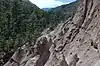 Bandelier National Monument |
October 15, 1966 (#66000042) |
12 miles (19 km) south of Los Alamos on State Road 4 35°46′32″N 106°19′06″W / 35.775556°N 106.318333°W |
Los Alamos | SRCP; extends into Sandoval and Santa Fe Counties; boundary increased 12/10/14 |
| 3 | Bayo Road | November 7, 2003 (#03001141) |
Approximately 420 feet northwest of the junction of Diamond Dr. and San Ildefonso Rd. 35°53′58″N 106°17′51″W / 35.899444°N 106.2975°W |
Los Alamos | ||
| 4 | Chupaderos Canyon Small Structural Site |  Chupaderos Canyon Small Structural Site |
November 7, 1990 (#90001585) |
Address Restricted |
Espanola | |
| 5 | Chupaderos Mesa Village | Chupaderos Mesa Village |
November 7, 1990 (#90001583) |
Address Restricted |
Espanola | |
| 6 | Grant Road | January 14, 2004 (#03001409) |
From near junction of Diamond Dr. and San Ildefonso Rd. to near Guaje Pines Cemetery. 35°53′57″N 106°17′54″W / 35.899167°N 106.298333°W |
Los Alamos | Historic homestead access route, now a hiking trail. SRCP Trails PDF | |
| 7 | Guaja Water/Soil Control Site | Guaja Water/Soil Control Site |
November 7, 1990 (#90001582) |
Address Restricted |
Espanola | |
| 8 | Guaje Site | Guaje Site |
December 7, 1982 (#82001049) |
Address Restricted |
Los Alamos | SRCP |
| 9 | Los Alamos Scientific Laboratory | 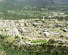 Los Alamos Scientific Laboratory |
October 15, 1966 (#66000893) |
Central Ave. 35°52′54″N 106°17′54″W / 35.881667°N 106.298333°W |
Los Alamos | |
| 10 | Lujan Road | January 12, 2005 (#04001478) |
Northeast of the junction of Diamond Dr. and San Ildefonso Rd. 35°53′49″N 106°16′52″W / 35.896944°N 106.281111°W |
Los Alamos | SRCP | |
| 11 | Pajarito Springs Site | 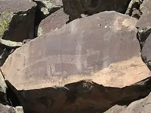 Pajarito Springs Site |
December 6, 1982 (#82001050) |
Address Restricted |
White Rock | SRCP |
| 12 | United States Post Office-Los Alamos, New Mexico | 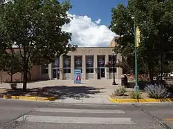 United States Post Office-Los Alamos, New Mexico |
August 3, 2015 (#15000493) |
199 Central Park Sq. 35°52′54″N 106°18′04″W / 35.8817°N 106.3010°W |
Los Alamos | SRCP |
| 13 | White Rock Canyon | 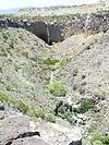 White Rock Canyon |
May 18, 1990 (#90000717) |
North of White Rock[5] 35°49′39″N 106°12′05″W / 35.827500°N 106.201458°W |
White Rock | SRCP |
See also
Wikimedia Commons has media related to National Register of Historic Places in Los Alamos County, New Mexico.
References
- ↑ The latitude and longitude information provided in this table was derived originally from the National Register Information System, which has been found to be fairly accurate for about 99% of listings. Some locations in this table may have been corrected to current GPS standards.
- ↑ National Park Service, United States Department of the Interior, "National Register of Historic Places: Weekly List Actions", retrieved January 12, 2024.
- ↑ Numbers represent an alphabetical ordering by significant words. Various colorings, defined here, differentiate National Historic Landmarks and historic districts from other NRHP buildings, structures, sites or objects.
- ↑ The eight-digit number below each date is the number assigned to each location in the National Register Information System database, which can be viewed by clicking the number.
- ↑ Location derived from its GNIS feature record; the NRIS lists it as "Address Restricted"
| Topics | |
|---|---|
| Lists by state |
|
| Lists by insular areas | |
| Lists by associated state | |
| Other areas | |
| Related | |
Municipalities and communities of Los Alamos County, New Mexico, United States | ||
|---|---|---|
| CDPs | Map of New Mexico highlighting Los Alamos County | |
This article is issued from Wikipedia. The text is licensed under Creative Commons - Attribution - Sharealike. Additional terms may apply for the media files.