Senonches | |
|---|---|
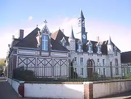 The town hall in Senonches | |
.svg.png.webp) Coat of arms | |
Location of Senonches | |
 Senonches 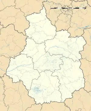 Senonches | |
| Coordinates: 48°33′44″N 1°01′53″E / 48.5622°N 1.0314°E | |
| Country | France |
| Region | Centre-Val de Loire |
| Department | Eure-et-Loir |
| Arrondissement | Dreux |
| Canton | Saint-Lubin-des-Joncherets |
| Government | |
| • Mayor (2020–2026) | Xavier Nicolas[1] |
| Area 1 | 62.48 km2 (24.12 sq mi) |
| Population | 2,985 |
| • Density | 48/km2 (120/sq mi) |
| Demonym | Senonchois·e |
| Time zone | UTC+01:00 (CET) |
| • Summer (DST) | UTC+02:00 (CEST) |
| INSEE/Postal code | 28373 /28250 |
| Elevation | 183–278 m (600–912 ft) |
| Website | http://www.senonches.com/ |
| 1 French Land Register data, which excludes lakes, ponds, glaciers > 1 km2 (0.386 sq mi or 247 acres) and river estuaries. | |
Senonches (French pronunciation: [sənɔ̃ʃ]) is a commune in Eure-et-Loir, Centre-Val de Loire, France.
Geography
Senonches is located northwest of the department of Eure-et-Loir and the northeastern boundary of the Regional Natural Park of the Perche, at a crossroads between the towns of Verneuil-sur-Avre (22 km), Mortagne-au-Perche (41 km), Nogent-le-Rotrou (33 km), Chartres (37 km) and Dreux (38 km). With 4,287 hectares, the forest of Senonches is the largest department, and one of the largest woods in France. It is much rich in plant species and shrubs. The country is also known for its springs and groundwater (in the forest) that supply a portion of the water distributed in Paris and is captured in Rueil-la-Gadelière.
Tourism
Senonches is surrounded by a vast forest (the largest in the department), formed mainly by oaks and beech, these remarkable trees can be explored on foot or by bike, including the "oak chair" and the "three brothers." The castle under renovation since 2003, will be reopened in Spring of 2012. Its tower dungeon made of a ferruginous stone, typical of the region, is very curious for most visitors.
Others
There is a market every Friday in the city center with many marketers. The Senonches Dreux airport, a NATO base, where fighters and bombers can take off (this base was turned into a photovoltaic solar plant in 2012).
Population
|
| ||||||||||||||||||||||||||||||||||||||||||||||||||||||||||||
| Source: EHESS[3] and INSEE (1968-2017)[4] | |||||||||||||||||||||||||||||||||||||||||||||||||||||||||||||
See also
References
- ↑ "Répertoire national des élus: les maires". data.gouv.fr, Plateforme ouverte des données publiques françaises (in French). 2 December 2020.
- ↑ "Populations légales 2021". The National Institute of Statistics and Economic Studies. 28 December 2023.
- ↑ Des villages de Cassini aux communes d'aujourd'hui: Commune data sheet Senonches, EHESS (in French).
- ↑ Population en historique depuis 1968, INSEE