Norristown, Georgia | |
|---|---|
 Norristown | |
| Coordinates: 32°30′25″N 82°29′39″W / 32.50694°N 82.49417°W | |
| Country | United States |
| State | Georgia |
| County | Emanuel |
| Area | |
| • Total | 0.41 sq mi (1.07 km2) |
| • Land | 0.41 sq mi (1.05 km2) |
| • Water | 0.01 sq mi (0.01 km2) |
| Elevation | 249 ft (76 m) |
| Population (2020) | |
| • Total | 54 |
| • Density | 133.00/sq mi (51.33/km2) |
| Time zone | UTC-5 (Eastern (EST)) |
| • Summer (DST) | UTC-4 (EDT) |
| ZIP code | 30447 |
| Area code | 478 |
| GNIS feature ID | 2587042[2] |
Norristown is an unincorporated community and census-designated place (CDP) in Emanuel County, Georgia, United States. Its population was 54 as of the 2020 census.[3]
Norristown has a post office with ZIP code 30447, which opened on May 8, 1878.[4][5] U.S. Route 221 passes through the community.
History
The Georgia General Assembly incorporated Norristown as a town in 1907.[6] The town's municipal charter was repealed in 1995.[7]
Demographics
| Census | Pop. | Note | %± |
|---|---|---|---|
| 2010 | 50 | — | |
| 2020 | 54 | 8.0% | |
| U.S. Decennial Census[8] 2010[9] 2020[9] | |||
Norristown was first listed as a CDP in the 2010 census.
| Race / Ethnicity | Pop 2010[9] | Pop 2020[10] | % 2010 | % 2020 |
|---|---|---|---|---|
| White alone (NH) | 53 | 47 | 89.83% | 87.04% |
| Black or African American alone (NH) | 4 | 4 | 6.78% | 7.41% |
| Native American or Alaska Native alone (NH) | 0 | 0 | 0.00% | 0.00% |
| Asian alone (NH) | 0 | 0 | 0.00% | 0.00% |
| Pacific Islander alone (NH) | 0 | 0 | 0.00% | 0.00% |
| Some Other Race alone (NH) | 0 | 0 | 0.00% | 0.00% |
| Mixed Race/Multi-Racial (NH) | 2 | 2 | 3.39% | 3.70% |
| Hispanic or Latino (any race) | 0 | 1 | 0.00% | 1.85% |
| Total | 50 | 54 | 100.00% | 100.00% |
References
- ↑ "2020 U.S. Gazetteer Files". United States Census Bureau. Retrieved December 18, 2021.
- ↑ "Norristown Census Designated Place". Geographic Names Information System. United States Geological Survey, United States Department of the Interior.
- ↑ "Norristown CDP, Georgia". United States Census Bureau.
- ↑ United States Postal Service. "USPS - Look Up a ZIP Code". Retrieved January 4, 2015.
- ↑ "Postmaster Finder - Post Offices by ZIP Code". United States Postal Service. Retrieved January 4, 2015.
- ↑ Acts Passed by the General Assembly of Georgia. J. Johnston. 1907. p. 850.
- ↑ Krakow, Kenneth K. (1975). Georgia Place-Names: Their History and Origins (PDF). Macon, GA: Winship Press. p. 160. ISBN 0-915430-00-2.
- ↑ "Census of Population and Housing". Census.gov. Retrieved June 4, 2016.
- 1 2 3 "P2 HISPANIC OR LATINO, AND NOT HISPANIC OR LATINO BY RACE – 2010: DEC Redistricting Data (PL 94-171) – Norristown CDP, Georgia". United States Census Bureau.
- ↑ "P2 HISPANIC OR LATINO, AND NOT HISPANIC OR LATINO BY RACE - 2020: DEC Redistricting Data (PL 94-171) – Norristown CDP, Georgia". United States Census Bureau.
Municipalities and communities of Emanuel County, Georgia, United States | ||
|---|---|---|
| Cities | 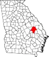 Map of Georgia highlighting Emanuel County | |
| CDPs | ||
| Unincorporated communities | ||
| Footnotes | ‡This populated place also has portions in an adjacent county or counties | |
This article is issued from Wikipedia. The text is licensed under Creative Commons - Attribution - Sharealike. Additional terms may apply for the media files.