Canoochee, Georgia | |
|---|---|
 Canoochee | |
| Coordinates: 32°40′20″N 82°10′44″W / 32.67222°N 82.17889°W | |
| Country | United States |
| State | Georgia |
| County | Emanuel |
| Area | |
| • Total | 2.41 sq mi (6.23 km2) |
| • Land | 2.36 sq mi (6.11 km2) |
| • Water | 0.05 sq mi (0.12 km2) |
| Elevation | 377 ft (115 m) |
| Population | |
| • Total | 70 |
| • Density | 29/sq mi (11/km2) |
| Time zone | UTC-5 (Eastern (EST)) |
| • Summer (DST) | UTC-4 (EDT) |
| Area code | 478 |
| GNIS feature ID | 2587027[2] |
Canoochee is an unincorporated community and census-designated place (CDP) in Emanuel County, Georgia, United States. Its population was 70 as of the 2020 census.[3]
Georgia State Route 192 passes through the community.
Demographics
| Census | Pop. | Note | %± |
|---|---|---|---|
| 2010 | 71 | — | |
| 2020 | 70 | −1.4% | |
| U.S. Decennial Census[4] 2010[5] 2020[6] | |||
Canoochee was first listed as a CDP in the 2010 census.
| Race / Ethnicity | Pop 2010[5] | Pop 2020[6] | % 2010 | % 2020 |
|---|---|---|---|---|
| White alone (NH) | 54 | 59 | 76.06% | 84.29% |
| Black or African American alone (NH) | 16 | 9 | 22.54% | 12.86% |
| Native American or Alaska Native alone (NH) | 0 | 0 | 0.00% | 0.00% |
| Asian alone (NH) | 1 | 0 | 1.41% | 0.00% |
| Pacific Islander alone (NH) | 0 | 0 | 0.00% | 0.00% |
| Some Other Race alone (NH) | 0 | 0 | 0.00% | 0.00% |
| Mixed Race/Multi-Racial (NH) | 0 | 2 | 0.00% | 2.86% |
| Hispanic or Latino (any race) | 0 | 0 | 0.00% | 0.00% |
| Total | 71 | 70 | 100.00% | 100.00% |
History
Linguist William Bright believes "Canoochee" may be a name derived from the Muscogee language, meaning "little ground".[7] The Georgia General Assembly incorporated the place as the "Town of Canoochee" in 1912, with town corporate limits extending in a one-half mile radius from the Savannah and Statesboro Railway depot.[8] The town's charter was officially dissolved in 1995.[9]
References
- ↑ "2020 U.S. Gazetteer Files". United States Census Bureau. Retrieved December 18, 2021.
- 1 2 "Canoochee Census Designated Place". Geographic Names Information System. United States Geological Survey, United States Department of the Interior.
- ↑ "Canoochee CDP, Georgia". United States Census Bureau.
- ↑ "Census of Population and Housing". Census.gov. Retrieved June 4, 2016.
- 1 2 "P2 HISPANIC OR LATINO, AND NOT HISPANIC OR LATINO BY RACE – 2010: DEC Redistricting Data (PL 94-171) – Canoochee CDP, Georgia". United States Census Bureau.
- 1 2 "P2 HISPANIC OR LATINO, AND NOT HISPANIC OR LATINO BY RACE - 2020: DEC Redistricting Data (PL 94-171) – Canoochee CDP, Georgia". United States Census Bureau.
- ↑ Bright, William (2004). Native American Placenames of the United States. University of Oklahoma Press. p. 80. ISBN 978-0-8061-3598-4.
- ↑ Acts and Resolutions of the General Assembly of the State of Georgia. State printer. 1912. p. 693.
- ↑ Krakow, Kenneth K. (1975). Georgia Place-Names: Their History and Origins (PDF). Macon, GA: Winship Press. p. 34. ISBN 0-915430-00-2.
Municipalities and communities of Emanuel County, Georgia, United States | ||
|---|---|---|
| Cities | 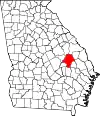 Map of Georgia highlighting Emanuel County | |
| CDPs | ||
| Unincorporated communities | ||
| Footnotes | ‡This populated place also has portions in an adjacent county or counties | |
This article is issued from Wikipedia. The text is licensed under Creative Commons - Attribution - Sharealike. Additional terms may apply for the media files.