There are over 9,000 Grade I listed buildings and 20,000 Grade II* listed buildings in England. This page is a list of these buildings in the London Borough of Barking and Dagenham.
Grade I
| Name | Location | Type | Completed [note 1] | Date designated | Grid ref.[note 2] Geo-coordinates |
Entry number [note 3] | Image |
|---|---|---|---|---|---|---|---|
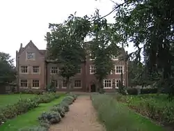
| Eastbury Manor House | Barking | Manor house | 16th century | 28 May 1954 | TQ4570983804 51°32′04″N 0°05′58″E / 51.534343°N 0.099398°E |
1359303 | |
| Garden walls of Eastbury Manor House | Barking | Garden wall | 16th century | 28 May 1954 | TQ4573983813 51°32′04″N 0°05′59″E / 51.534416°N 0.099834°E |
1064414 |  Upload Photo |
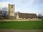
| Parish Church of St Margaret | Barking | Parish church | 13th century | 28 May 1954 | TQ4406583891 51°32′08″N 0°04′33″E / 51.535546°N 0.075748°E |
1064408 |
Grade II*
| Name | Location | Type | Completed [note 1] | Date designated | Grid ref.[note 2] Geo-coordinates |
Entry number [note 3] | Image |
|---|---|---|---|---|---|---|---|
| Church of St Peter and St Paul | Dagenham | Church | 1688 | 28 June 1954 | TQ5004384530 51°32′21″N 0°09′50″E / 51.539203°N 0.1637872°E |
1359302 | |
| Eastbrook public house | Dagenham | Public house | Built 1937–38 | 11 December 2009 | TQ4996585842 51°33′04″N 0°09′48″E / 51.551013°N 0.1632224°E |
1393600 | .jpg.webp) Eastbrook public house |
| Fire Bell Gate, Barking Abbey | Barking | Gate | Early 19th century | 28 May 1954 | TQ4409683947 51°32′08″N 0°04′40″E / 51.535516°N 0.0778481°E |
1064407 | 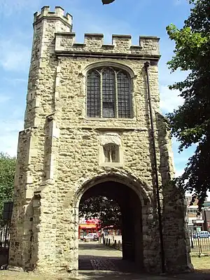 Fire Bell Gate, Barking Abbey |
| Valence House | Becontree | House | 13th century | 28 June 1954 | TQ4804486539 51°33′28″N 0°08′09″E / 51.557785°N 0.1358266°E |
1064404 |

Grade II
| Name | Location | Type | Completed [note 1] | Date designated | Grid ref.[note 2] Geo-coordinates |
Entry number [note 3] | Image |
|---|---|---|---|---|---|---|---|
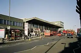
| Barking station | Barking | station | 13 April 1854 | 24 November 1995 | TQ4435184373 51°32′21″N 0°04′54″E / 51.5393°N 0.0817°E |
1242678 | |
| Civic Centre | Dagenham | Building | October 1937 | 24 August 1981 | TQ4951986869 51°33′37″N 0°09′22″E / 51.5603°N 0.15615°E |
1064422 | |
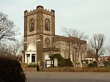
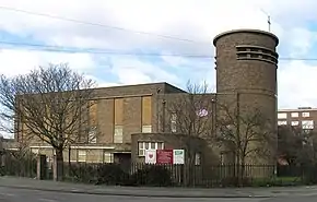
| St Patrick's Church | Barking | Church | July 1940 | 10 September 2009 | TQ4542283725 51°32′01″N 0°05′43″E / 51.5337°N 0.0952°E |
1393196 |

Notes
- 1 2 3 The date given is the date used by Historic England as significant for the initial building or that of an important part in the structure's description.
- 1 2 3 Sometimes known as OSGB36, the grid reference is based on the British national grid reference system used by the Ordnance Survey.
- 1 2 3 The "List Entry Number" is a unique number assigned to each listed building and scheduled monument by Historic England.
External links
 Media related to Grade I listed buildings in the London Borough of Barking and Dagenham at Wikimedia Commons
- Media related to Grade II* listed buildings in the London Borough of Barking and Dagenham at Wikimedia Commons
- Media related to Grade II listed buildings in the London Borough of Barking and Dagenham at Wikimedia Commons
| Districts |   | |
|---|---|---|
| Attractions | ||
| Places of worship | ||
| Parks and open spaces | ||
| Constituencies |
| |
| Tube and rail stations | ||
| Other topics | ||
| ||
This article is issued from Wikipedia. The text is licensed under Creative Commons - Attribution - Sharealike. Additional terms may apply for the media files.