Yazd County
Persian: شهرستان یزد | |
|---|---|
County | |
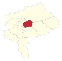 Location of Yazd County in Yazd province | |
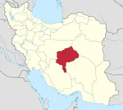 Location of Yazd province in Iran | |
| Coordinates: 31°56′N 54°30′E / 31.933°N 54.500°E[1] | |
| Country | |
| Province | Yazd |
| Capital | Yazd |
| Districts | Central, Zarach |
| Population (2016)[2] | |
| • Total | 656,474 |
| Time zone | UTC+3:30 (IRST) |
| Yazd County can be found at GEOnet Names Server, at this link, by opening the Advanced Search box, entering "9207381" in the "Unique Feature Id" form, and clicking on "Search Database". | |
Yazd County (Persian: شهرستان یزد) is in Yazd province, Iran. Its capital is the city of Yazd.[3]
At the 2006 census, the county's population was 515,044 in 138,108 households.[4] The following census in 2011 counted 582,682 people in 168,458 households.[5] At the 2016 census, the county's population was 656,474 in 195,134 households.[2]
Administrative divisions
The population history of Yazd County's administrative divisions over three consecutive censuses is shown in the following table. The latest census shows two districts, four rural districts, and four cities.[2]
In February 2023, Akramabad District was established in the county and divided into two rural districts. Zarach District was separated from the county in the establishment of Zarach County, which was divided into two districts and three rural districts, with Zarach as its capital and only city.[6]
| Administrative Divisions | 2006[4] | 2011[5] | 2016[2] |
|---|---|---|---|
| Central District | 499,808 | 564,125 | 635,687 |
| Fahraj RD | 22,659 | 22,708 | 34,511 |
| Fajr RD | 12,158 | 1,266 | 1,401 |
| Hamidiya (city) | 27,611 | 37,428 | 51,793 |
| Shahediyeh (city) | 14,374 | 16,571 | 18,309 |
| Yazd (city) | 423,006 | 486,152 | 529,673 |
| Akramabad District1 | |||
| Akramabad RD1 | |||
| Dehnow RD1 | |||
| Zarach District2 | 15,236 | 18,557 | 20,786 |
| Allahabad RD | 3,475 | 4,991 | 5,908 |
| Mohammadabad RD | 1,782 | 2,813 | 3,187 |
| Zarach (city) | 9,979 | 10,753 | 11,691 |
| Total | 515,044 | 582,682 | 656,474 |
| RD: Rural District 1Established after the 2016 census[6] 2Became a part of Zarach County after the 2016 census[6] | |||
References
- ↑ OpenStreetMap contributors (6 April 2023). "Yazd County" (Map). OpenStreetMap. Retrieved 6 April 2023.
- 1 2 3 4 "Census of the Islamic Republic of Iran, 1395 (2016)". AMAR (in Persian). The Statistical Center of Iran. p. 21. Archived from the original (Excel) on 18 November 2020. Retrieved 19 December 2022.
- ↑ "Approval of the organization and chain of citizenship of the elements and units of the national divisions of Yazd province centered on Yazd city". Lamtakam (in Persian). Ministry of Interior, Council of Ministers. 21 June 1369. Archived from the original on 18 December 2023. Retrieved 18 December 2023.
- 1 2 "Census of the Islamic Republic of Iran, 1385 (2006)". AMAR (in Persian). The Statistical Center of Iran. p. 21. Archived from the original (Excel) on 20 September 2011. Retrieved 25 September 2022.
- 1 2 "Census of the Islamic Republic of Iran, 1390 (2011)". Syracuse University (in Persian). The Statistical Center of Iran. p. 21. Archived from the original (Excel) on 20 January 2023. Retrieved 19 December 2022.
- 1 2 3 Mokhbar, Mohammad (23 February 1401). "Approval letter regarding country divisions of Yazd County". Laws and Regulations Portal of Iran (in Persian). Ministry of Interior, Board of Ministers. Archived from the original on 12 February 2023. Retrieved 18 December 2023.
Yazd Province, Iran | |||||||||||||||||||||
|---|---|---|---|---|---|---|---|---|---|---|---|---|---|---|---|---|---|---|---|---|---|
| Capital |  | ||||||||||||||||||||
| Counties and cities |
| ||||||||||||||||||||
| Landmarks |
| ||||||||||||||||||||
| populated places | |||||||||||||||||||||
| Capital | |||||||||||||||||||||
|---|---|---|---|---|---|---|---|---|---|---|---|---|---|---|---|---|---|---|---|---|---|
| Districts |
| ||||||||||||||||||||