Wiota, Wisconsin | |
|---|---|
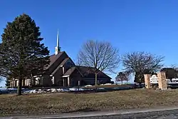 Wiota Lutheran Church | |
 Wiota  Wiota | |
| Coordinates: 42°38′12″N 89°57′09″W / 42.63667°N 89.95250°W | |
| Country | |
| State | |
| County | Lafayette |
| Town | Wiota |
| Area | |
| • Total | 2.001 sq mi (5.18 km2) |
| • Land | 2.001 sq mi (5.18 km2) |
| • Water | 0 sq mi (0 km2) |
| Elevation | 997 ft (304 m) |
| Population | |
| • Estimate (2017) | 97 |
| • Density | 48.5/sq mi (18.7/km2) |
| Time zone | UTC-6 (Central (CST)) |
| • Summer (DST) | UTC-5 (CDT) |
| Area code | 608 |
| GNIS feature ID | 1576892[3] |
| FIPS code | 55-88025 |
Wiota is an unincorporated community and census-designated place (CDP) in the town of Wiota, Lafayette County, Wisconsin, United States. Wiota is located on Wisconsin Highway 78 6.2 miles (10.0 km) southwest of Argyle.[4] Its population was estimated to be 97 in 2017.[2]
Geography
Wiota is in eastern Lafayette County, in the west-central part of the town of Wiota. According to the U.S. Census Bureau, the CDP has an area of 2.0 square miles (5.2 km2), all of it land.[1] The community sits on a ridge at the headwaters of Feather Branch, a south-flowing tributary of the Pecatonica River.
References
- 1 2 "2020 U.S. Gazetteer Files – Wisconsin". United States Census Bureau. Retrieved March 29, 2021.
- 1 2 "Wiota CDP, Wisconsin". American FactFinder. U.S. Census Bureau. Archived from the original on February 14, 2020. Retrieved September 23, 2019.
- ↑ "Wiota". Geographic Names Information System. United States Geological Survey, United States Department of the Interior.
- ↑ Lafayette County (PDF) (Map). Wisconsin Department of Transportation. 2011. Archived from the original (PDF) on January 30, 2012. Retrieved January 29, 2012.
Municipalities and communities of Lafayette County, Wisconsin, United States | ||
|---|---|---|
| Cities | 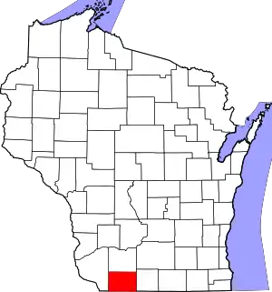 | |
| Villages | ||
| Towns | ||
| CDPs | ||
| Other communities | ||
| Footnotes | ‡This populated place also has portions in an adjacent county or counties | |
This article is issued from Wikipedia. The text is licensed under Creative Commons - Attribution - Sharealike. Additional terms may apply for the media files.