Waldbredimus
Waldbriedemes | |
|---|---|
 | |
 Coat of arms | |
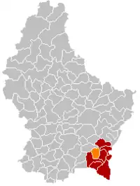 Map of Luxembourg with Waldbredimus highlighted in orange, and the canton in dark red | |
| Coordinates: 49°33′25″N 6°17′15″E / 49.5569°N 6.2875°E | |
| Country | |
| Canton | Remich |
| Area | |
| • Total | 12.57 km2 (4.85 sq mi) |
| • Rank | 86th of 102 |
| Highest elevation | 359 m (1,178 ft) |
| • Rank | 77th of 102 |
| Lowest elevation | 170 m (560 ft) |
| • Rank | 13th of 102 |
| Population (2023) | |
| • Total | 1,337 |
| • Rank | 98th of 102 |
| • Density | 110/km2 (280/sq mi) |
| • Rank | 68th of 102 |
| Time zone | UTC+1 (CET) |
| • Summer (DST) | UTC+2 (CEST) |
| LAU 2 | LU0001208 |
| Website | waldbredimus.lu |
Waldbredimus (Luxembourgish: Waldbriedemes) is a small town and former commune in south-eastern Luxembourg. It is part of the canton of Remich, which is part of the district of Grevenmacher. The commune's administrative centre is Trintange. The commune of Waldbredimus merged with the commune of Bous to form the new commune of Bous-Waldbredimus on 1 September 2023.[1]
As of 2005, the town of Waldbredimus, which lies in the centre of the commune, has a population of 376. Other towns within the commune include Ersange and Trintange.
Twin towns – sister cities
Waldbredimus is twinned with:[2]
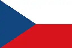 Hrušky, Czech Republic
Population
References
- ↑ "Legilux". legilux.public.lu. Retrieved 2023-06-12.
- ↑ "Obec Hrusky" (in French). Waldbredimus. Retrieved 2023-11-12.
- ↑ "Population par canton et commune". statistiques.public.lu. Retrieved 11 January 2022.
External links
 Media related to Waldbredimus at Wikimedia Commons
This article is issued from Wikipedia. The text is licensed under Creative Commons - Attribution - Sharealike. Additional terms may apply for the media files.