Usiacurí | |
|---|---|
.svg.png.webp) Flag  Seal | |
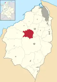 Location of the municipality and town of Usiacurí in the Department of Atlántico. | |
 Usiacurí | |
| Coordinates: 10°45′N 74°59′W / 10.750°N 74.983°W | |
| Country | |
| Region | Caribbean |
| Department | Atlántico |
| Demonym | Usiacureno,-a |
| Government | |
| • Mayor | Monica Urueta Torrealba (Radical Change)[1] |
| Area | |
| • Total | 103 km2 (40 sq mi) |
| Elevation | 95 m (312 ft) |
| Population (Census 2018[3]) | |
| • Total | 9,543 |
| • Density | 93/km2 (240/sq mi) |
| Time zone | UTC-5 (Colombia Standard Time) |
| Website | www.usiacuri-atlantico.gov.co/sitio.shtml |
Usiacurí is a municipality and town in the Colombian department of Atlántico.
References
- ↑ (in Spanish) National Registry of the Civil State: 2007 regional election results
- ↑ "Municipalities of Colombia". statoids. Retrieved 10 May 2020.
- ↑ "Censo Nacional de Población y Vivienda 2018" (in Spanish). DANE. Retrieved 10 May 2020.
External links
- (in Spanish) Gobernacion del Atlantico - Usiacurí
- (in Spanish) Usiacurí official website
Municipalities in the Atlántico Department | ||
|---|---|---|
This article is issued from Wikipedia. The text is licensed under Creative Commons - Attribution - Sharealike. Additional terms may apply for the media files.