| Turnbull Creek Tributary to Cape Fear River | |
|---|---|
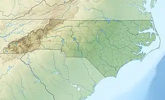 Location of Turnbull Creek mouth  Turnbull Creek (Cape Fear River tributary) (the United States) | |
| Location | |
| Country | United States |
| State | North Carolina |
| County | Bladen Cumberland |
| Physical characteristics | |
| Source | between Bushy Lake and Rollins Pond |
| • location | about 5 miles west-southwest of Roseboro, North Carolina |
| • coordinates | 34°54′19″N 078°41′10″W / 34.90528°N 78.68611°W[1] |
| • elevation | 110 ft (34 m)[2] |
| Mouth | Cape Fear River |
• location | about 1.5 miles east of Elizabethtown, North Carolina |
• coordinates | 34°37′29″N 078°33′24″W / 34.62472°N 78.55667°W[1] |
• elevation | 23 ft (7.0 m)[2] |
| Length | 27.78 mi (44.71 km)[3] |
| Basin size | 88.27 square miles (228.6 km2)[4] |
| Discharge | |
| • location | Cape Fear River |
| • average | 91.99 cu ft/s (2.605 m3/s) at mouth with Cape Fear River[4] |
| Basin features | |
| Progression | Cape Fear River → Atlantic Ocean |
| River system | Cape Fear River |
| Tributaries | |
| • left | Little Turnbull Creek Indian Creek White Lake Drain Tubmill Creek |
| • right | Briary Stream Spring Branch Panther Branch Smith Swamp |
| Bridges | Turnbull Road, Squatting Bear Drive, Avery Road, Walter West Road, Braxton Edge Road, NC 242, Lula Long Road, Johnsontown Road, Sweet Home Church Road, Old Hoover Bridge Road, US 701-NC 41 |
Turnbull Creek is a 27.78 mi (44.71 km) long 3rd order tributary to the Cape Fear River in Bladen County, North Carolina.
Course
Turnbull Creek rises in between Bushy Lake and Rollins Pond, a Carolina Bay, about 5 miles east of Roseboro, North Carolina in Cumberland County. Turnbull Creek then flows southeast to Bladen County to join the Cape Fear River about 1.5 miles east of Elizabethtown, North Carolina.[2]
Watershed
Turnbull Creek drains 88.27 square miles (228.6 km2) of area, receives about 49.1 in/year of precipitation, has a wetness index of 617.26 and is about 23% forested.[4]
See also
References
- 1 2 "GNIS Detail - Turnbull Creek". geonames.usgs.gov. US Geological Survey. Retrieved 13 September 2020.
- 1 2 3 "Turnbull Creek Topo Map in Bladen". TopoZone. Locality, LLC. Retrieved 13 September 2020.
- ↑ "ArcGIS Web Application". epa.maps.arcgis.com. US EPA. Retrieved 13 September 2020.
- 1 2 3 "Turnbull Creek Watershed Report". US EPA Geoviewer. US EPA. Retrieved 13 September 2020.
This article is issued from Wikipedia. The text is licensed under Creative Commons - Attribution - Sharealike. Additional terms may apply for the media files.