South Konawe Regency
Kabupaten Konawe Selatan | |
|---|---|
 Coat of arms | |
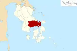 Location within Southeast Sulawesi | |
| Coordinates: 3°24′41″S 122°01′12″E / 3.4114°S 122.0200°E | |
| Country | Indonesia |
| Province | Southeast Sulawesi |
| Capital | Andoolo |
| Government | |
| • Regent | Surunuddin Dangga |
| • Vice Regent | Arsalim |
| Area | |
| • Total | 4,237.74 km2 (1,636.20 sq mi) |
| Population (mid 2022 estimate)[1] | |
| • Total | 317,826 |
| • Density | 75/km2 (190/sq mi) |
| Time zone | UTC+8 (ICST) |
| Area code | (+62) 401 |
| Website | konaweselatankab |
South Konawe Regency (Kabupaten Konawe Selatan) is a regency of Southeast Sulawesi Province, Indonesia. It covers an area of 4,237.74 km2 and had a population of 264,587 at the 2010 Census[2] and of 308,524 at the 2020 Census;[3] the official estimate as at mid 2022 was 317,826 - comprising 162,949 males and 154,877 females.[1] The administrative centre is in the town of Andoolo.
Administrative districts
At the time of the 2010 Census, the South Konawe Regency was divided into twenty-two districts (kecamatan), but since 2010, three additional districts have been created in 2014 by the division of existing districts - Andoolo Barat, Kolono Timur and Sabulakoa. These districts are tabulated below with their areas and their populations at the 2010 Census[2] and 2020 Census,[3] together with the official estimates for mid 2022.[1] The table also includes the locations of the district administrative centres, the number of administrative villages in each district (totaling 336 rural desa and 15 urban kelurahan), and its postal code.
| Kode Wilayah | Name of District (kecamatan) | Area in km2 | Pop'n Census 2010 | Pop'n Census 2020 | Pop'n Estimate mid 2022 | Admin centre | No. of villages | Post code |
|---|---|---|---|---|---|---|---|---|
| 74.05.01 | Tinanggea | 320.37 | 21,320 | 24,971 | 25,716 | Tinanggea | 24 (a) | 93886 |
| 74.05.12 | Lalembu | 147.90 | 15,603 | 16,057 | 16,127 | Atari Indah | 18 (b) | 93885 |
| 74.05.03 | Andoolo | 118.66 | 16,316 | 10,563 | 10,901 | Andoolo | 10 (a) | 93810 - 93819 |
| 74.05.17 | Buke | 181.38 | 13,236 | 14,558 | 14,811 | Buke | 16 | 93812 - 93819 |
| 74.05.25 | Andoolo Barat (West Andoolo) | 79.67 | (c) | 8,751 | 9,031 | Anese | 10 | 93813 - 93819 |
| 74.05.04 | Palangga | 173.75 | 12,287 | 14,792 | 15,315 | Palangga | 15 (b) | 93882 |
| 74.05.14 | Palangga Selatan (South Palangga) | 107.64 | 6,139 | 7,392 | 7,654 | Lakara | 10 (b) | 93884 |
| 74.05.20 | Baito | 151.71 | 7,562 | 9,004 | 9,302 | Baito | 8 | 93883 |
| 74.05.06 | Lainea | 205.11 | 8,870 | 10,038 | 10,269 | Lainea | 12 | 93881 |
| 74.05.19 | Laeya | 276.72 | 19,005 | 21,458 | 21,942 | Punggaluku | 17 (a) | 93880 |
| 74.05.09 | Kolono (d) | 340.29 | 13,602 | 11,397 | 11,853 | Kolono | 21 (b) | 93895 |
| 74.05.23 | Kolono Timur (East Kolono) | 125.01 | (e) | 5,360 | 5,574 | Tumbi-tumbu Jaya | 10 | 93894 |
| 74.05.11 | Laonti (f) | 373.77 | 9,444 | 10,309 | 10,473 | Ulusawah | 19 | 93892 |
| 74.05.10 | Moramo (g) | 254.26 | 12,976 | 15,634 | 16,189 | Lapuko | 20 (b) | 93891 |
| 74.05.16 | Moramo Utara (h) (North Moramo) | 159.76 | 7,174 | 8,867 | 9,227 | Lalowaru | 10 (b) | 93890 |
| 74.05.07 | Konda | 127.13 | 18,131 | 21,724 | 22,471 | Konda | 18 (b) | 93874 |
| 74.05.18 | Wolasi | 158.92 | 4,730 | 5,656 | 5,848 | Aoma | 6 | 93878 |
| 74.05.08 | Ranomeeto | 90.26 | 16,223 | 21,049 | 22,111 | Ranomeeto | 12 (b) | 93870 |
| 74.05.22 | Ranomeeto Barat (West Ranomeeto) | 69.50 | 6,517 | 7,986 | 8,297 | Lameuru | 9 | 93871 |
| 74.05.05 | Landono | 109.76 | 11,470 | 8,392 | 8,691 | Landono | 13 (b) | 93873 |
| 74.05.15 | Mowila | 122.89 | 11,188 | 13,700 | 14,231 | Mowila | 20 | 93879 |
| 74.05.24 | Sabulakoa | 66.53 | (i) | 5,436 | 5,630 | Sabulakoa | 8 | 93872 |
| 74.05.02 | Angata | 294.10 | 14,905 | 16,811 | 17,187 | Motaha | 24 | 93875 |
| 74.05.13 | Benua | 133.91 | 9,734 | 10,897 | 11,124 | Horodopi | 12 | 93877 |
| 784.05.21 | Basala | 48.73 | 8,155 | 7,722 | 7,852 | Basala | 9 | 93876 |
| Totals | 4,237.74 | 264,587 | 308,524 | 317,826 | Andoolo | 351 |
Notes: (a) includes 2 kelurahan. (b) includes one kelurahan.
(c) the 2010 population of Andoolo Barat District is included in the figure for Andoolo District, from which it was cut out in 2014.
(d) includes the offshore island of Pulau Tawatawaro.
(e) the 2010 population of Kolono Timur District is included in the figure for Kolono District, from which it was cut out in 2014.
(f) includes 20 offshore islands. (g) includes 3 offshore islands. (h) includes the offshore islands of Pulau Lara and Pulau Moramo.
(i) the 2010 population of Sabulakoa District is included in the figure for Landono District, from which it was cut out in 2014.
Climate
South Konawe has a tropical rainforest climate (Af) with moderate rainfall from August to November and heavy rainfall from December to July. The following climate data is for the town of Andoolo, the seat of the regency.
| Climate data for Andoolo | |||||||||||||
|---|---|---|---|---|---|---|---|---|---|---|---|---|---|
| Month | Jan | Feb | Mar | Apr | May | Jun | Jul | Aug | Sep | Oct | Nov | Dec | Year |
| Mean daily maximum °C (°F) | 30.9 (87.6) |
30.8 (87.4) |
30.8 (87.4) |
30.7 (87.3) |
30.1 (86.2) |
29.3 (84.7) |
29.0 (84.2) |
29.7 (85.5) |
30.7 (87.3) |
31.9 (89.4) |
32.0 (89.6) |
31.2 (88.2) |
30.6 (87.1) |
| Daily mean °C (°F) | 26.9 (80.4) |
26.9 (80.4) |
26.8 (80.2) |
26.9 (80.4) |
26.6 (79.9) |
25.9 (78.6) |
25.4 (77.7) |
25.6 (78.1) |
26.2 (79.2) |
27.1 (80.8) |
27.6 (81.7) |
27.1 (80.8) |
26.6 (79.9) |
| Mean daily minimum °C (°F) | 23.0 (73.4) |
23.0 (73.4) |
22.9 (73.2) |
23.1 (73.6) |
23.1 (73.6) |
22.5 (72.5) |
21.8 (71.2) |
21.6 (70.9) |
21.8 (71.2) |
22.3 (72.1) |
23.2 (73.8) |
23.1 (73.6) |
22.6 (72.7) |
| Average rainfall mm (inches) | 199 (7.8) |
198 (7.8) |
220 (8.7) |
199 (7.8) |
240 (9.4) |
220 (8.7) |
152 (6.0) |
103 (4.1) |
94 (3.7) |
70 (2.8) |
119 (4.7) |
173 (6.8) |
1,987 (78.3) |
| Source: Climate-Data.org[4] | |||||||||||||
References
Regencies and cities of Southeast Sulawesi | ||
|---|---|---|
Capital: Kendari | ||
| Regencies | ||
| Cities | ||
3°24′41″S 122°01′12″E / 3.4114°S 122.0200°E