Shukul Bazar
Bāzār Shukul | |
|---|---|
Town | |
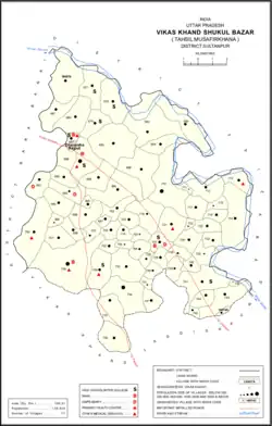 Map showing Shukul Bazar CD block | |
 Shukul Bazar Location in Uttar Pradesh, India | |
| Coordinates: 26°36′10″N 81°34′57″E / 26.602751°N 81.582598°E[1] | |
| Country | |
| State | Uttar Pradesh |
| Division | Faizabad division |
| District | Sultanpur |
| Languages | |
| • Official | Hindi, Urdu |
| Time zone | UTC+5:30 (IST) |
Shukul Bazar, also called Bazar Shukul or more rarely Mawaiya-Rahmatgarh, is a town[2] and community development block[3] in Musafirkhana tehsil of Sultanpur district, Uttar Pradesh, India.[3][2] It is located on the road from Inhauna to Rudauli.[2]
At the turn of the 20th century, Shukul Bazar was described as the only real town in the otherwise mostly rural tehsil of Musafirkhana.[2] It had an important market and was the headquarters of a police thana which, despite its small jurisdiction, was very busy due to a lot of unrest in the area.[2] It also had a post office and one of the largest schools in the tehsil.[2]
The market at Shukul Bazar is held on Wednesdays and Sundays and mostly deals in cloth.[4] As of 1961, it had an average attendance of around 500 people.[4] At that point, the town also had a government-run dispensary with 2 beds for males and 2 for females, and it had a police force consisting of 1 sub-inspector, 1 head constable, and 12 constables.[4]
History
Sukul bazar, founded about a century ago by some members of a well to do Sukul ( Brahmin ) family . It shared with Perkinsginj the advantage of being near the Gumti .
Villages
Shukul Bazar CD block has the following 71 villages:[3]
| Village name | Total land area (hectares) | Population (in 2011) |
|---|---|---|
| Manjh Gaon | 647.7 | 2,123 |
| Sansarpur | 358.5 | 1,570 |
| Khemmau | 417.4 | 3,161 |
| Tendua | 231.5 | 2,383 |
| Dakkhin Gaon Kyar | 394.9 | 4,566 |
| Shivali | 207 | 2,069 |
| Pali | 840.6 | 4,432 |
| Urer Mau | 566.9 | 2,872 |
| Tenwasi | 179.1 | 1,438 |
| Bubupur | 683.2 | 4,049 |
| Ahamadpur | 415.9 | 3,826 |
| Dhanesha Rajput | 94 | 1,602 |
| Mawaiya Rahmat Garh | 511.2 | 7,795 |
| Indriya | 263.1 | 2,139 |
| Ekkatajpur | 180.5 | 1,550 |
| Husen Pur | 218.8 | 2,050 |
| Sidhauli | 203 | 988 |
| Daranagar | 66.6 | 1,255 |
| Harkhu Mau | 536.2 | 3,119 |
| Sewara | 259 | 2,788 |
| Nimpur | 206 | 1,227 |
| Newaj Bhadar Garh | 105.6 | 2,315 |
| Nihal Garh Saida Patti | 161.6 | 1,439 |
| Pure Dayagir | 51.1 | 236 |
| Unch Gaon | 823.1 | 4,537 |
| Khalish Bahadur Pur | 221.6 | 1,832 |
| Gayas Pur | 243.3 | 1,756 |
| Kaji Pur | 290.4 | 1,009 |
| Ashis Pur | 104.1 | 2,001 |
| Nirhi Garh | 46 | 379 |
| Sidhana Mau | 170.2 | 845 |
| Fatte Pur | 87.6 | 848 |
| Mahauna Paschim | 1,061.9 | 11,220 |
| Mahauna Purab | 473.1 | 4,348 |
| Kisuni | 689.4 | 6,032 |
| Shahpur Shamshul Haque | 50.4 | 195 |
| Nadi | 351.5 | 2,307 |
| Bhandara Shekh Pur | 233.4 | 1,241 |
| Makhdum Kalan | 689.2 | 4,798 |
| Laliha Mau | 70.1 | 357 |
| Badal Garh | 184.4 | 1,768 |
| Jodil Mau | 170.3 | 1,105 |
| Banarpur | 76.3 | 819 |
| Mardanpur | 365.8 | 3,514 |
| Sujanpur | 58.3 | 462 |
| Baharpur | 450.4 | 4,778 |
| Puredip Chand | 50.5 | 302 |
| Bakhtawar Nagar | 108.6 | 1,131 |
| Muhiuddin Pur | 122 | 1,081 |
| Chhajju Pur | 164 | 462 |
| Para | 183.9 | 1,342 |
| Kundan Pur | 135.3 | 1,682 |
| Bhatmau | 128.2 | 1,201 |
| Jalali | 61.1 | 660 |
| Balapur | 82.6 | 723 |
| Sahabgarh | 47.1 | 401 |
| Saraiya Peerzada | 56.6 | 1,224 |
| Byaure Mau | 374.1 | 2,587 |
| Barsanda | 473.1 | 5,584 |
| Sauna | 295.8 | 2,461 |
| Rasul Pur | 326 | 4,200 |
| Tevar Pur | 156.1 | 2,313 |
| Hasanpur Tiwari | 130.7 | 844 |
| Jamuwari | 134.1 | 972 |
| Vishambher Patti | 112.7 | 1,633 |
| Sathin | 539.8 | 4,529 |
| Tirai | 1 | 0 |
| Mandwa | 311.8 | 2,178 |
| Baj Garh | 186.5 | 2,025 |
| Fazil Pur | 74 | 883 |
| Rondawa | 64.6 | 963 |
References
- ↑ "Geonames Search". Do a radial search using these coordinates here.
- 1 2 3 4 5 6 Nevill, H.R. (1903). Sultanpur: A Gazetteer, Being Volume XLVI Of The District Gazetteers Of The United Provinces Of Agra And Oudh. Allahabad: Government Press. pp. 185, 199–201. Retrieved 13 November 2021.
- 1 2 3 "Census of India 2011: Uttar Pradesh District Census Handbook - Sultanpur, Part A (Village and Town Directory)" (PDF). Census 2011 India. pp. 77–93. Retrieved 13 November 2021.
- 1 2 3 Census 1961: District Census Handbook, Uttar Pradesh (44 - Sultanpur District) (PDF). Lucknow. 1965. pp. 118, 121, 147. Retrieved 13 November 2021.
{{cite book}}: CS1 maint: location missing publisher (link)