Sainte-Marie-aux-Chênes | |
|---|---|
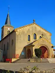 The church in Sainte-Marie-aux-Chênes | |
 Coat of arms | |
Location of Sainte-Marie-aux-Chênes | |
 Sainte-Marie-aux-Chênes 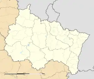 Sainte-Marie-aux-Chênes | |
| Coordinates: 49°11′32″N 6°00′11″E / 49.1922°N 6.0031°E | |
| Country | France |
| Region | Grand Est |
| Department | Moselle |
| Arrondissement | Metz |
| Canton | Rombas |
| Intercommunality | Pays Orne-Moselle |
| Government | |
| • Mayor (2020–2026) | Sylvie Lamarque[1] |
| Area 1 | 10.19 km2 (3.93 sq mi) |
| Population | 4,505 |
| • Density | 440/km2 (1,100/sq mi) |
| Time zone | UTC+01:00 (CET) |
| • Summer (DST) | UTC+02:00 (CEST) |
| INSEE/Postal code | 57620 /57255 |
| Elevation | 205–323 m (673–1,060 ft) (avg. 290 m or 950 ft) |
| 1 French Land Register data, which excludes lakes, ponds, glaciers > 1 km2 (0.386 sq mi or 247 acres) and river estuaries. | |
Sainte-Marie-aux-Chênes (French pronunciation: [sɛ̃t maʁi o ʃɛn]; German: Marieneichen) is a commune in the Moselle department in Grand Est in north-eastern France.[3]
Population
| Year | Pop. | ±% p.a. |
|---|---|---|
| 1968 | 3,365 | — |
| 1975 | 3,326 | −0.17% |
| 1982 | 3,317 | −0.04% |
| 1990 | 3,302 | −0.06% |
| 1999 | 3,328 | +0.09% |
| 2007 | 3,589 | +0.95% |
| 2012 | 3,959 | +1.98% |
| 2017 | 4,216 | +1.27% |
| Source: INSEE[4] | ||
Coat of arms
The town's name means "Saint Mary at the oaks" in French, and the town's coat of arms can be described as canting: Azure an oak tree eradicated or, between two letters S and M of the last.
See also
References
- ↑ "Répertoire national des élus: les maires". data.gouv.fr, Plateforme ouverte des données publiques françaises (in French). 2 December 2020.
- ↑ "Populations légales 2021". The National Institute of Statistics and Economic Studies. 28 December 2023.
- ↑ INSEE commune file
- ↑ Population en historique depuis 1968, INSEE
External links
 Media related to Sainte-Marie-aux-Chênes at Wikimedia Commons
This article is issued from Wikipedia. The text is licensed under Creative Commons - Attribution - Sharealike. Additional terms may apply for the media files.