Sagua la Chica | |
|---|---|
Rural settlement | |
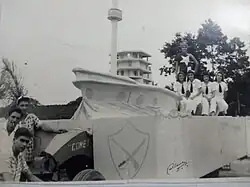 Carriage of the Parrandas of the Barrio La Marina in Sagua La Chica, 1960 | |
.png.webp) Sagua la Chica (red) in Camajuaní (orange) in Villa Clara (yellow) | |
.svg.png.webp) Sagua la Chica Location in Cuba 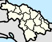 Sagua la Chica Sagua la Chica (Villa Clara Province)  Sagua la Chica Sagua la Chica (Camajuaní) | |
| Coordinates: 22°41′22″N 79°41′44″W / 22.68944°N 79.69556°W | |
| Country | Cuba |
| Province | Villa Clara |
| Municipality | Camajuani |
| Area | |
| • Total | 0.4004 km2 (0.1546 sq mi) |
| Population | |
| • Total | 1,447 |
| • Density | 3,600/km2 (9,400/sq mi) |
| Postal Code | 52400 [2] |
Sagua la Chica also known as Sagua is a rural settlement in Camajuani, Cuba. It has a population of 1,447 people.[3] Sagua la Chica has the same name as the Sagua la Chica river and is 174 mi (or 280 km) away from the capital of Havana.
Education
There is one school in the town, which is: [4]
- Restituto Muñiz Primary
Geography
Towns nearby Sagua la Chica include Resulta, Hermanos Toledo, Jumagua, Colonia Miguel del Sol (also known as Miguel del Sol), Jagüey, and Crucero Carolina (also known as just Carolina).[5]
The town of Sagua la Chica borders the municipality of Encrucijada and is in the ward of Batalla de Santa Clara.[6]
Economy
According at the DMPF (Departamento de control de la Dirección Municipal de Planificación Física or Management Control Department Municipal Physical Planning in English) of Camajuani, Sagua la Chica is a settlement not linked to any source of an economic or job development but still are maintained. [7] : page 68
History

Until 1976 Sagua was a barrio of the former municipality of Vueltas.
In 2018, several settlements in Villa Clara were flooded, in Camajuaní these settlements included Rincón, Guajén, Sagua la Chica, Macagual, Guerrero, Floridano, Vega Alta, and Vega de Palma. [8]
Resources
Vega Alta, Sagua la Chica, and Crecencio Valdés are the only towns in Camajuani that make clay. [7] : page 77
See also
References
- ↑ "Sagua la Chica (Camajuaní, Villa Clara Province, Cuba) - Population Statistics, Charts, Map, Location, Weather and Web Information". www.citypopulation.de.
- ↑ "Sagua la Chica Postcodes, Postal Codes, ZIP Codes, Sagua la Chica PIN Code and Elevation. - AZPostcodes.com". www.azpostcodes.com.
- ↑ "Sagua la Chica (Camajuaní, Villa Clara Province, Cuba) - Population Statistics, Charts, Map, Location, Weather and Web Information". www.citypopulation.de. Retrieved 2022-09-10.
- ↑ "Portal del Ciudadano en Camajuaní - Educación". www.soycamajuani.gob.cu. Retrieved 2022-12-23.
- ↑ "List of Cities near Sagua la Grande in Villa Clara, Cuba". www.gomapper.com. Retrieved 2022-09-11.
- ↑ "Mapa de Cuba la provincia Villa Clara el municipio Camajuani". ResearchGate.
- 1 2 Barroso, Joel Jiménez; Figueroa Vidal, Dr. Arq. Carlos. R. "Diagnóstico estratégico de la situación habitacional del municipio de Camajuaní" (PDF).
- ↑ "Francisnet Díaz Rondón". www.facebook.com. Retrieved 2023-07-18.