Qalat-e Bala
Persian: قلات بالا | |
|---|---|
Village | |
 Qalat-e Bala | |
| Coordinates: 27°19′10″N 56°05′35″E / 27.31944°N 56.09306°E[1] | |
| Country | |
| Province | Hormozgan |
| County | Bandar Abbas |
| District | Central |
| Rural District | Tazian |
| Population (2016)[2] | |
| • Total | 2,223 |
| Time zone | UTC+3:30 (IRST) |
Qalat-e Bala (Persian: قلات بالا, also Romanized as Qalāt-e Bālā; also known as Kalāt and Kalāt-e Bālā)[3] is a village in Tazian Rural District of the Central District of Bandar Abbas County, Hormozgan province, Iran.
At the 2006 National Census, its population was 2,898 in 650 households.[4] The following census in 2011 counted 3,465 people in 902 households.[5] The latest census in 2016 showed a population of 2,223 people in 626 households. It was the largest village in its rural district.[2]
References
- ↑ OpenStreetMap contributors (4 September 2023). "Qalat-e Bala, Bandar Abbas County" (Map). OpenStreetMap. Retrieved 4 September 2023.
- 1 2 "Census of the Islamic Republic of Iran, 1395 (2016)". AMAR (in Persian). The Statistical Center of Iran. p. 22. Archived from the original (Excel) on 5 May 2022. Retrieved 19 December 2022.
- ↑ Qalat-e Bala can be found at GEOnet Names Server, at this link, by opening the Advanced Search box, entering "-3068819" in the "Unique Feature Id" form, and clicking on "Search Database".
- ↑ "Census of the Islamic Republic of Iran, 1385 (2006)". AMAR (in Persian). The Statistical Center of Iran. p. 22. Archived from the original (Excel) on 20 September 2011. Retrieved 25 September 2022.
- ↑ "Census of the Islamic Republic of Iran, 1390 (2011)" (Excel). Iran Data Portal (in Persian). The Statistical Center of Iran. p. 22. Retrieved 19 December 2022.
Hormozgan Province, Iran | |||||||||||||||||||||||||
|---|---|---|---|---|---|---|---|---|---|---|---|---|---|---|---|---|---|---|---|---|---|---|---|---|---|
| Capital | 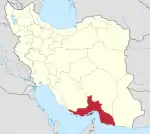 | ||||||||||||||||||||||||
| Counties and cities |
| ||||||||||||||||||||||||
| Sights |
| ||||||||||||||||||||||||
| populated places | |||||||||||||||||||||||||
| See also | |||||||||||||||||||||||||
This article is issued from Wikipedia. The text is licensed under Creative Commons - Attribution - Sharealike. Additional terms may apply for the media files.