Prudnik Land
| |
|---|---|
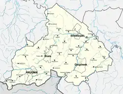 Map of the Prudnik Land | |
| Coordinates: 50°19′N 17°34′E / 50.31°N 17.57°E | |
| Country | |
| Largest city | Prudnik |
| Population | |
| • Total | 71,430 |
| Time zone | UTC+1 (CET) |
| • Summer (DST) | UTC+2 (CEST) |
Prudnik Land (Polish: ziemia prudnicka, German: Neustädter Land) is a part of the historical region of Upper Silesia, located in southwestern Poland. It's named after the town of Prudnik (historically known as Neustadt O.S. in German), the largest town in the region.
Towns located in the region are: Prudnik, Biała, Głogówek and Strzeleczki.
Throughout a large part of its history, the region had been ruled by the Duchy of Opole and other Silesian Duchies. Following the Silesian Wars the region found itself within Prussia. In accordance with the Oder–Neisse line, Poland received the Prudnik Land in 1945.
Geography
Prudnik Land is located in the southwestern part of Upper Silesia, in the region known as Opolian Silesia, near the Czech Republic–Poland border. The western edge of the Prudnik Landmarks the border between historic Upper and Lower Silesia.[1]
In the current administrative division, the Prudnik Land is located in the Opole Voivodeship. The current Prudnik County does not coincide with its borders. In addition to the entire area of Prudnik County (gminas of Prudnik, Lubrza, Głogówek and Biała), the Prudnik Land also includes the entire gmina Strzeleczki, gmina Walce excluding the village of Stradunia, the villages of Borek, Kórnica, Nowy Dwór Prudnicki, Pietna, Steblów and Ściborowice in gmina Krapkowice, villages Jarnołtówek and Pokrzywna in gmina Głuchołazy, villages Biernatów and Klisino, and villages Ścinawa Mała, Borek, Przechód and Rzymkowice in gmina Korfantów.[1]

The southwestern part of the Prudnik Land is located in the Opawskie Mountains (Eastern Sudetes). Mountains can be found in the vicinity of Prudnik, Jarnołtówek, Pokrzywna, Moszczanka, Wieszczyna, Dębowiec and Trzebina. The highest mountains in the Prudnik Land are: Biskupia Kopa (890 m), Srebrna Kopa (785 m) and Zamkowa Góra (571 m). The area around Głogówek and Strzeleczki is mostly flat land. The area near Biała is characterized by numerous hills. Most of the Prudnik Land is occupied by fertile soils. The most fertile soils are located in the vicinity of Wierzch, southwest of Głogówek and near Biała. The least fertile soils are found near the villages of Dobra, Steblów, Wawrzyńcowice, Mokra, Brzeźnica.[2]
References
- 1 2 Dereń, Andrzej. "Historia Powiatu Prudnickiego". powiatprudnicki.pl (in Polish). Retrieved 2024-01-06.
- ↑ "Powiat prudnicki z perspektywy roku 1784". hkknos.eu (in Polish). Retrieved 2024-01-06.