Otnice | |
|---|---|
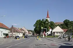
 Centre of Otnice | |
 Flag  Coat of arms | |
 Otnice Location in the Czech Republic | |
| Coordinates: 49°5′11″N 16°48′52″E / 49.08639°N 16.81444°E | |
| Country | |
| Region | South Moravian |
| District | Vyškov |
| First mentioned | 1255 |
| Area | |
| • Total | 8.70 km2 (3.36 sq mi) |
| Elevation | 216 m (709 ft) |
| Population (2023-01-01)[1] | |
| • Total | 1,587 |
| • Density | 180/km2 (470/sq mi) |
| Time zone | UTC+1 (CET) |
| • Summer (DST) | UTC+2 (CEST) |
| Postal code | 683 54 |
| Website | www |
Otnice is a municipality and village in Vyškov District in the South Moravian Region of the Czech Republic. It has about 1,600 inhabitants.
Etymology
The name Otnice is derived from the personal name Oten.[2]
Geography
Otnice is located about 17 kilometres (11 mi) southeast of Brno. It lies in an agricultural landscape, which mostly belongs to the Ždánice Forest. The northwestern part of the municipal territory extends into the Dyje–Svratka Valley. The highest point is the flat hill Malý Sádkový vrch at 268 m (879 ft) above sea level. The municipality is situated at the confluence of two small brooks, Otnický potok and Bošovický potok.
History
The first written mention of Otnice is from 1255.[2]
Demographics
|
|
| ||||||||||||||||||||||||||||||||||||||||||||||||||||||
| Source: Censuses[3][4] | ||||||||||||||||||||||||||||||||||||||||||||||||||||||||
Economy
The municipality is mainly focused on agriculture.[2]
Transport
There are no railways or major roads passing through the municipality.
Sights
The main landmark of Otnice is the Church of Saint Aloysius. The current Neo-Renaissance structure was built in 1855–1856.[2]
References
- ↑ "Population of Municipalities – 1 January 2023". Czech Statistical Office. 2023-05-23.
- 1 2 3 4 "Základní údaje" (in Czech). Obec Otnice. Retrieved 2023-02-14.
- ↑ "Historický lexikon obcí České republiky 1869–2011 – Okres Vyškov" (in Czech). Czech Statistical Office. 2015-12-21. pp. 5–6.
- ↑ "Population Census 2021: Population by sex". Public Database. Czech Statistical Office. 2021-03-27.