Nishapur County
Persian: شهرستان نیشابور | |
|---|---|
County | |
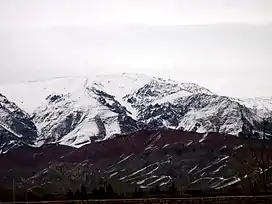 Mount Binalud, located within the county | |
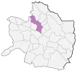 Location of Nishapur County in Razavi Khorasan province | |
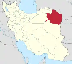 Location of Razavi Khorasan province in Iran | |
| Coordinates: 36°25′26″N 58°37′31″E / 36.42389°N 58.62528°E[1] | |
| Country | |
| Province | Razavi Khorasan |
| Named for | Shapur I |
| Capital | Nishapur |
| Districts | Central, Sarvelayat |
| Area | |
| • Total | 5,653 km2 (2,183 sq mi) |
| Population (2016)[2] | |
| • Total | 451,780 |
| • Density | 80/km2 (210/sq mi) |
| Demonym | Neyshaburi |
| Time zone | UTC+3:30 (IRST) |
| Nishapur County at GEOnet Names Server | |
Nishapur County (Persian: شهرستان نیشابور, Šahrestâne Neyšhâbur), or officially Romanized as Neyshabur County, is in Razavi Khorasan province, Iran. Its capital is the city of Nishapur,[3] the second largest city in the province and the third largest city in Eastern Iran.
At the 2006 census, the county's population was 441,184 in 118,214 households.[4] The following census in 2011 counted 433,105 people in 128,969 households,[5] by which time Taghenkuh District and most of Takht-e Jolgeh District had been separated from the county in the establishment of Firuzeh County, and Binalud Rural District had been transferred to the Central District.[6] At the 2016 census, the county's population was 451,780 in 142,545 households.[2]
Administrative divisions
The population history and structural changes of Nishapur County's administrative divisions over three consecutive censuses are shown in the following table. The latest census shows four districts, 13 rural districts, and seven cities.[2]
After the census, Zeberkhan District was separated from the county in the establishment of Zeberkhan County.[7] Additionally, Miyan Jolgeh District was separated in the establishment of Miyan Jolgeh County.[8]
| Administrative Divisions | 2006[4] | 2011[5] | 2016[2] |
|---|---|---|---|
| Central District | 274,700 | 319,576 | 341,182 |
| Binalud RD | 5,742 | 5,635 | |
| Darbqazi RD | 10,411 | 9,854 | 9,528 |
| Fazl RD | 15,323 | 17,121 | 15,792 |
| Mazul RD | 30,375 | 34,718 | 33,791 |
| Rivand RD | 12,619 | 8,835 | 8,296 |
| Bar (city) | 4,121 | 3,765 | |
| Nishapur (city) | 205,972 | 239,185 | 264,375 |
| Miyan Jolgeh District1 | 37,117 | 38,478 | 39,288 |
| Belharat RD | 11,677 | 11,896 | 12,074 |
| Eshqabad RD | 15,280 | 15,711 | 16,270 |
| Ghazali RD | 8,835 | 8,988 | 8,951 |
| Eshqabad (city) | 1,325 | 1,883 | 1,993 |
| Sarvelayat District | 17,962 | 17,445 | 14,664 |
| Barzanun RD | 6,032 | 5,693 | 4,764 |
| Sarvelayat RD | 10,567 | 9,918 | 8,519 |
| Chekneh (city) | 1,363 | 1,834 | 1,381 |
| Taghenkuh District2 | 22,562 | ||
| Taghenkuh-e Jonubi RD | 6,876 | ||
| Taghenkuh-e Shomali RD | 15,686 | ||
| Takht-e Jolgeh District | 34,267 | ||
| Binalud RD | 7,006 | ||
| Firuzeh RD2 | 9,292 | ||
| Takht-e Jolgeh RD2 | 13,063 | ||
| Firuzeh (city)2 | 4,906 | ||
| Zeberkhan District3 | 54,576 | 57,606 | 56,635 |
| Eshaqabad RD | 10,110 | 10,623 | 11,234 |
| Ordughesh RD | 9,788 | 8,556 | 8,174 |
| Zeberkhan RD | 14,762 | 15,149 | 14,965 |
| Darrud (city) | 4,979 | 5,449 | 5,717 |
| Kharv (city) | 11,931 | 14,115 | 13,535 |
| Qadamgah (city) | 3,006 | 3,714 | 3,010 |
| Total | 441,184 | 433,105 | 451,780 |
| RD: Rural District 1Became a part of Miyan Jolgeh County after the 2016 census[8] 2Became a part of Firuzeh County[6] 3Became a part of Zeberkhan County after the 2016 census[7] | |||
History
Nishapur massacre by the Mongols
The Nishapur massacre by the Mongols took place at Nishapur in April of 1221. The Mongol armies of Genghis Khan massacred the entire population of the area, which some estimates put at 1,747,000 citizens.[9]
References
- ↑ OpenStreetMap contributors (5 May 2023). "Nishapur County" (Map). OpenStreetMap. Retrieved 5 May 2023.
- 1 2 3 4 "Census of the Islamic Republic of Iran, 1395 (2016)". AMAR (in Persian). The Statistical Center of Iran. p. 09. Archived from the original (Excel) on 2 April 2022. Retrieved 19 December 2022.
- ↑ Habibi, Hassan (21 June 1369). "Approval of the organization and chain of citizenship of the elements and units of the divisions of Khorasan province, centered in Mashhad". Lamtakam (in Persian). Ministry of Interior, Defense Political Commission of the Government Council. Archived from the original on 27 December 2023. Retrieved 27 December 2023.
- 1 2 "Census of the Islamic Republic of Iran, 1385 (2006)". AMAR (in Persian). The Statistical Center of Iran. p. 09. Archived from the original (Excel) on 20 September 2011. Retrieved 25 September 2022.
- 1 2 "Census of the Islamic Republic of Iran, 1390 (2011)". Syracuse University (in Persian). The Statistical Center of Iran. p. 09. Archived from the original (Excel) on 20 January 2023. Retrieved 19 December 2022.
- 1 2 Davodi, Parviz (24 July 1386). "Approval letter regarding reforms of country divisions in Razavi Khorasan province, Nishapur County". Islamic Parliament Research Center. Ministry of Interior, Council of Ministers. Archived from the original on 17 November 2015. Retrieved 17 November 2023.
- 1 2 Jahangiri, Ishaq (21 February 2019). "Approval letter regarding the establishment of Heshmatiyeh Rural District in Zeberkhan District of Nishapur County, Razavi Khorasan province". Qavanin (in Persian). Ministry of Interior, Board of Ministers. Archived from the original on 2 November 2020. Retrieved 11 May 2023.
- 1 2 Mokhbar, Mohammad (11 December 1401). "Changing the center of Eshqabad Rural District, Miyan Jolgeh District of Nishapur County, Razavi Khorasan province to Raisi village and the center of Belharat Rural District to Rigi village". Qavanin. Ministry of Interior, Board of Ministers. Archived from the original on 2 July 2023. Retrieved 17 November 2023.
- ↑ DEATH BY GOVERNMENT

| Capital | |||||||||||||||||||||||||||
|---|---|---|---|---|---|---|---|---|---|---|---|---|---|---|---|---|---|---|---|---|---|---|---|---|---|---|---|
| Districts |
| ||||||||||||||||||||||||||