
Location of Silver Bow County in Montana
This is a list of the National Register of Historic Places listings in Silver Bow County, Montana. It is intended to be a complete list of the properties and districts on the National Register of Historic Places in Silver Bow County, Montana, United States. The locations of National Register properties and districts for which the latitude and longitude coordinates are included below, may be seen in a map.[1]
There are 21 properties and districts listed on the National Register in the county, including 2 National Historic Landmarks.
This National Park Service list is complete through NPS recent listings posted December 22, 2023.[2]
Listings county-wide
| [3] | Name on the Register | Image | Date listed[4] | Location | City or town | Description |
|---|---|---|---|---|---|---|
| 1 | Basin Creek Park Historic District | November 27, 2023 (#100009566) |
Approximately 9 miles (14 km) south of Butte on Basin Creek Rd. (393) 45°51′22″N 112°32′45″W / 45.8560°N 112.5459°W |
Butte vicinity | ||
| 2 | Big Hole Pumpstation | 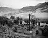 Big Hole Pumpstation |
September 24, 1980 (#80002432) |
Montana Highway 43 45°45′50″N 112°47′14″W / 45.763889°N 112.787222°W |
Butte | |
| 3 | Butte, Anaconda and Pacific Railway Historic District | 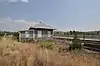 Butte, Anaconda and Pacific Railway Historic District |
October 13, 1988 (#88001111) |
Right-of-way begins in Butte and travels to Anaconda, generally along the course of Silver Bow Creek; also the confluence of German Gulch and Silver Bow Creeks at the eastern end of Silver Bow Canyon 46°02′37″N 112°44′25″W / 46.043611°N 112.740278°W |
Butte | Extends into Deer Lodge County. Location at the confluence represents a boundary increase, added on January 13, 1989 |
| 4 | Butte-Anaconda Historic District | 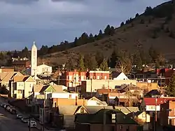 Butte-Anaconda Historic District |
October 15, 1966 (#66000438) |
Most of the developed areas of Anaconda, Butte, and Walkerville 46°00′55″N 112°32′10″W / 46.015278°N 112.536111°W |
Butte and Walkerville | Extends into Deer Lodge County |
| 5 | Charles W. Clark Mansion | _-_Silver_Bow_County%252C_Montana.png.webp) Charles W. Clark Mansion |
October 22, 1976 (#76001128) |
108 N. Washington St. 46°00′49″N 112°32′28″W / 46.013611°N 112.541111°W |
Butte | |
| 6 | W. A. Clark Mansion | _2002-05.jpg.webp) W. A. Clark Mansion |
October 6, 1970 (#70000366) |
219 W. Granite 46°00′52″N 112°32′21″W / 46.014444°N 112.539167°W |
Butte | |
| 7 | Hawthorne Grade School | 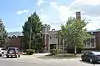 Hawthorne Grade School |
January 25, 1988 (#87002304) |
3500 White Way 45°58′28″N 112°29′16″W / 45.974444°N 112.487778°W |
Butte | |
| 8 | Homestake Airway Beacon | May 31, 2019 (#100004037) |
Along Continental Divide at Homestake Pass in Beaverhead-Deerlodge National Forest 45°55′11″N 112°25′00″W / 45.9196°N 112.4167°W |
Butte vicinity | Extends into Jefferson County. | |
| 9 | Longfellow Grade School | January 25, 1988 (#87002305) |
1629 Roosevelt Ave. 45°58′47″N 112°30′54″W / 45.979722°N 112.515°W |
Butte | Demolished in 2007 | |
| 10 | Madison Grade School | _-_Silver_Bow_County%252C_Montana.png.webp) Madison Grade School |
January 25, 1988 (#87002306) |
45 E. Greenwood 45°59′24″N 112°32′06″W / 45.99°N 112.535°W |
Butte | |
| 11 | Matt's Place Drive-In | _-_Silver_Bow_County%252C_Montana.png.webp) Matt's Place Drive-In |
March 29, 2001 (#01000308) |
2339 Placer St. 45°59′30″N 112°32′18″W / 45.991667°N 112.538333°W |
Butte | |
| 12 | Parrot Mine Shops Complex | _-_Silver_Bow_County%252C_Montana.png.webp) Parrot Mine Shops Complex |
January 9, 2007 (#06001228) |
244 Anaconda Rd. 46°01′01″N 112°31′41″W / 46.016944°N 112.528056°W |
Butte | |
| 13 | Ramsay Historic District | 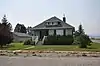 Ramsay Historic District |
January 14, 1988 (#87002227) |
6.5 miles west of Butte on Interstate 90 46°00′20″N 112°41′09″W / 46.005556°N 112.685833°W |
Butte | |
| 14 | Shaffer's Chapel African Methodist Episcopal Church | December 3, 2018 (#100003199) |
602 S Idaho 46°00′24″N 112°32′25″W / 46.0067°N 112.5404°W |
Butte | ||
| 15 | Silver Bow Airway Beacon | May 25, 2019 (#100004023) |
Approximately 3 miles northwest of Ramsay 46°03′06″N 112°42′45″W / 46.0518°N 112.7124°W |
Ramsay vicinity | ||
| 16 | Silver Bow Brewery Malt House |  Silver Bow Brewery Malt House |
January 19, 1983 (#83001076) |
West of Butte off U.S. Route 91 46°00′22″N 112°38′35″W / 46.006111°N 112.643056°W |
Butte | |
| 17 | Silver Bow County Poor Farm Hospital | 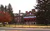 Silver Bow County Poor Farm Hospital |
July 16, 1981 (#81000366) |
3040 Continental Dr. 45°59′04″N 112°29′09″W / 45.984444°N 112.485833°W |
Butte | |
| 18 | Socialist Hall | 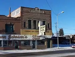 Socialist Hall |
May 26, 1995 (#95000661) |
1957 Harrison Ave. 45°59′39″N 112°30′45″W / 45.994167°N 112.5125°W |
Butte | |
| 19 | U.S. Post Office | 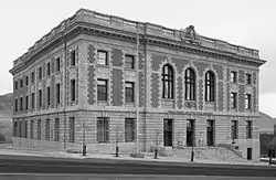 U.S. Post Office |
November 15, 1979 (#79001426) |
400 N. Main St 46°00′52″N 112°32′19″W / 46.014444°N 112.538611°W |
Butte | |
| 20 | Burton K. Wheeler House | _-_Silver_Bow_County%252C_Montana.png.webp) Burton K. Wheeler House |
December 8, 1976 (#76001129) |
1232 E. 2nd St. 46°00′20″N 112°31′13″W / 46.005556°N 112.520278°W |
Butte | |
| 21 | Wold Barn | January 8, 2009 (#08001287) |
Southwestern corner of the junction of Hecla and 3rd Sts. 45°37′50″N 112°41′14″W / 45.630494°N 112.687244°W |
Melrose | Barn from 1906. |
See also
Wikimedia Commons has media related to National Register of Historic Places in Silver Bow County, Montana.
References
- ↑ The latitude and longitude information provided in this table was derived originally from the National Register Information System, which has been found to be fairly accurate for about 99% of listings. Some locations in this table may have been corrected to current GPS standards.
- ↑ National Park Service, United States Department of the Interior, "National Register of Historic Places: Weekly List Actions", retrieved December 22, 2023.
- ↑ Numbers represent an alphabetical ordering by significant words. Various colorings, defined here, differentiate National Historic Landmarks and historic districts from other NRHP buildings, structures, sites or objects.
- ↑ The eight-digit number below each date is the number assigned to each location in the National Register Information System database, which can be viewed by clicking the number.
| Lists by county |
|  |
|---|---|---|
| Other lists |
| |
Municipalities and communities of Silver Bow County, Montana, United States | ||
|---|---|---|
| City | Silver Bow County map | |
| Town | ||
| Unincorporated communities | ||
| Ghost town | ||
| Neighborhoods | ||
| Footnotes | ‡This populated place also has portions in an adjacent county or counties | |
This article is issued from Wikipedia. The text is licensed under Creative Commons - Attribution - Sharealike. Additional terms may apply for the media files.