List of the National Register of Historic Places listings in Rhinebeck, New York
This is intended to be a complete list of properties and districts listed (and one formerly listed) on the National Register of Historic Places in the town and village of Rhinebeck, New York, including in the hamlet of Rhinecliff. The locations of National Register properties and districts (at least for all showing latitude and longitude coordinates below) may be seen in an online map by clicking on "Map of all coordinates".[1]
This National Park Service list is complete through NPS recent listings posted January 5, 2024.[2]
| Albany (Albany) – Allegany – Bronx – Broome – Cattaraugus – Cayuga – Chautauqua – Chemung – Chenango – Clinton – Columbia – Cortland – Delaware – Dutchess (Poughkeepsie, Rhinebeck) – Erie (Buffalo) – Essex – Franklin – Fulton – Genesee – Greene – Hamilton – Herkimer – Jefferson – Kings – Lewis – Livingston – Madison – Monroe (Rochester) – Montgomery – Nassau – New York (Below 14th Street, 14th to 59th Streets, 59th to 110th Streets, Above 110th Street, Islands) – Niagara (Niagara Falls) – Oneida – Onondaga (Syracuse) – Ontario – Orange – Orleans – Oswego – Otsego – Putnam – Queens – Rensselaer – Richmond – Rockland – St. Lawrence – Saratoga – Schenectady – Schoharie – Schuyler – Seneca – Steuben – Suffolk – Sullivan – Tioga – Tompkins – Ulster – Warren – Washington – Wayne – Westchester (Northern, Southern, New Rochelle, Peekskill, Yonkers) – Wyoming – Yates |
Listed on the National Register
| [3] | Name on the Register | Image | Date listed[4] | Location | City or town | Description |
|---|---|---|---|---|---|---|
| 1 | Astor Home for Children | 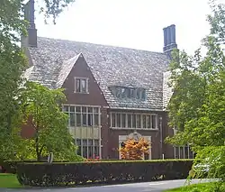 Astor Home for Children |
July 9, 1987 (#87001098) |
36 Mill St. 41°55′29″N 73°54′49″W / 41.924722°N 73.913611°W |
Rhinebeck | 1914 institutional building by McKim, Mead and White in Jacobean Revival style |
| 2 | Barringer Farmhouse | July 9, 1987 (#87001076) |
US 9 41°53′39″N 73°54′49″W / 41.894167°N 73.913611°W |
Rhinebeck | ||
| 3 | Benner House | 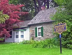 Benner House |
July 9, 1987 (#87001067) |
1 Mill St. 41°55′14″N 73°54′36″W / 41.920556°N 73.91°W |
Rhinebeck | 1739 stone house is rare example of Hudson Valley one-room house in German vernacular tradition. It is the Oldest House in Rhinebeck Village. |
| 4 | Cox Farmhouse | 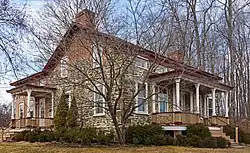 Cox Farmhouse |
July 9, 1987 (#87001078) |
Old Post Rd. N 41°56′54″N 73°54′34″W / 41.948333°N 73.909444°W |
Rhinebeck | 18th-century stone house remodeled in mid-19th century |
| 5 | Henry Delamater House | 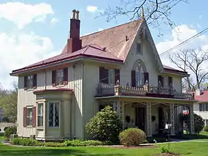 Henry Delamater House |
May 7, 1973 (#73001185) |
44 Montgomery St. 41°55′42″N 73°54′49″W / 41.928333°N 73.913611°W |
Rhinebeck | Very ornate 1844 Carpenter Gothic house |
| 6 | Evangelical Lutheran Church of St. Peter | 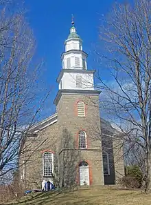 Evangelical Lutheran Church of St. Peter |
April 24, 1975 (#75001182) |
2.25 mi (3.62 km). N of Rhinebeck on U.S. 9 41°57′45″N 73°53′12″W / 41.9625°N 73.886667°W |
Rhinebeck | 1786 rural stone church built for congregation started in 1730s. Known locally as Old Stone Church. |
| 7 | Evergreen Lands | July 9, 1987 (#87001096) |
Delano Dr. 41°53′06″N 73°54′25″W / 41.885°N 73.906944°W |
Rhinebeck | ||
| 8 | Fredenburg House | July 9, 1987 (#87001068) |
Old Post Rd. 41°54′04″N 73°54′45″W / 41.901111°N 73.9125°W |
Rhinebeck | ||
| 9 | Free Church Parsonage | 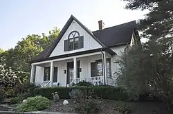 Free Church Parsonage |
July 9, 1987 (#87001090) |
Jct. of William and Grinnell Sts. 41°55′03″N 73°57′09″W / 41.9175°N 73.9525°W |
Rhinecliff | |
| 10 | Grasmere | 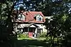 Grasmere |
July 9, 1987 (#87001093) |
Mill Rd. 41°54′48″N 73°54′43″W / 41.913333°N 73.911944°W |
Rhinebeck | |
| 11 | The Grove | 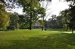 The Grove |
July 9, 1987 (#87001094) |
Jct. of Miller Rd. and NY 308 41°56′24″N 73°52′40″W / 41.94°N 73.877778°W |
Rhinebeck | |
| 12 | Heermance House and Law Office | 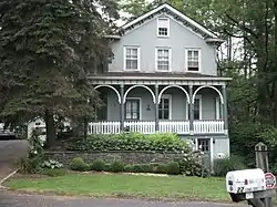 Heermance House and Law Office |
July 9, 1987 (#87001091) |
Jct. of Rhinecliff and Long Dock Rds. 41°55′42″N 73°56′39″W / 41.928333°N 73.944167°W |
Rhinecliff | |
| 13 | Hillside Methodist Church | 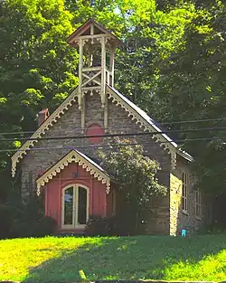 Hillside Methodist Church |
July 9, 1987 (#87001084) |
US 9 41°53′06″N 73°54′42″W / 41.885°N 73.911667°W |
Rhinebeck | |
| 14 | Hudson River Heritage Historic District | 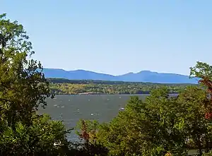 Hudson River Heritage Historic District |
December 14, 1990 (#90002219) |
E. side Hudson R. between Germantown and Staatsburg 41°55′42″N 73°56′14″W / 41.928434°N 73.937190°W |
Rhinecliff | 35-square-mile (91 km2) strip of Hudson River shoreline and inland with land use and architecture strongly reflecting quasi-feudal ownership |
| 15 | Kip-Beekman-Heermance Site (A027-16-0223) | 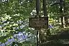 Kip-Beekman-Heermance Site (A027-16-0223) |
April 19, 1989 (#89000260) |
County Rd 85 41°55′34″N 73°56′45″W / 41.9260°N 73.9457°W |
Rhinecliff | Site of Kip-Beekman House; historic marker on site |
| 16 | Mansakenning | July 9, 1987 (#87001095) |
Ackert Hook Rd. 41°54′18″N 73°54′00″W / 41.905°N 73.9°W |
Rhinebeck | ||
| 17 | The Maples | 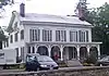 The Maples |
July 9, 1987 (#87001092) |
108 Montgomery St. 41°56′09″N 73°54′57″W / 41.935833°N 73.915833°W |
Rhinebeck | 1833 Greek Revival house with 1860s Picturesque detailing. |
| 18 | J. W. Moore House | 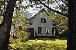 J. W. Moore House |
July 9, 1987 (#87001085) |
245 Mill Rd. 41°53′59″N 73°55′37″W / 41.899722°N 73.926944°W |
Rhinebeck | |
| 19 | Morton Memorial Library | 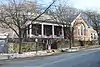 Morton Memorial Library |
July 9, 1987 (#87001089) |
Kelly St. 41°55′08″N 73°57′06″W / 41.918889°N 73.951667°W |
Rhinecliff | 1905 Colonial Revival house situated on a small knoll along a local street. |
| 20 | Neher-Elseffer House | 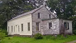 Neher-Elseffer House |
April 18, 2003 (#03000246) |
6196 US 9 41°57′32″N 73°53′32″W / 41.958889°N 73.892222°W |
Rhinebeck | 1746 house is a rare surviving pre-Revolutionary frame house in area. Now owned by town. |
| 21 | O'Brien General Store and Post Office | 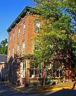 O'Brien General Store and Post Office |
July 9, 1987 (#87001088) |
Jct. of Schatzell Ave. and Charles St. 41°55′11″N 73°57′06″W / 41.919722°N 73.951667°W |
Rhinecliff | |
| 22 | Jan Pier House | 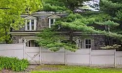 Jan Pier House |
July 9, 1987 (#87001073) |
NY 308 41°55′43″N 73°53′45″W / 41.92855°N 73.89594°W |
Rhinebeck | 1761 Dutch stone house remodeled with mansard roof in 1881 |
| 23 | Pilgrim's Progress Road Bridge | 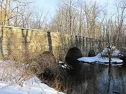 Pilgrim's Progress Road Bridge |
July 9, 1987 (#87001102) |
Miller Rd. S of NY 308 41°56′22″N 73°52′50″W / 41.939444°N 73.880556°W |
Rhinebeck | |
| 24 | Progue House | 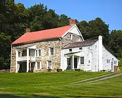 Progue House |
July 9, 1987 (#87001072) |
Primrose Hill Rd. 41°53′17″N 73°52′53″W / 41.888056°N 73.881389°W |
Rhinebeck | |
| 25 | Rhinebeck Village Historic District | 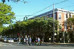 Rhinebeck Village Historic District |
August 8, 1979 (#79001578) |
U.S. 19 and NY 308; also portions of Platt Ave., Mill, Oak, Mulberry, and North Parsonage Sts. 41°55′41″N 73°54′33″W / 41.928056°N 73.909167°W |
Rhinebeck | Well-preserved and cohesive collection of historic buildings; boundary increase approved January 15, 2021 |
| 26 | Rhinecliff Hotel | 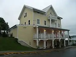 Rhinecliff Hotel |
July 9, 1987 (#87001087) |
Schatzell Ave. 41°55′11″N 73°57′10″W / 41.919722°N 73.952778°W |
Rhinecliff | |
| 27 | Riverside Methodist Church and Parsonage | 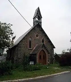 Riverside Methodist Church and Parsonage |
July 9, 1987 (#87001086) |
Charles and Orchard Sts. 41°55′12″N 73°57′03″W / 41.92°N 73.950833°W |
Rhinecliff | |
| 28 | Rock Ledge | November 28, 1989 (#89002010) |
Roughly Ackert Hook Rd., Haggerty Hill Rd., and Troy Dr. 41°53′41″N 73°53′43″W / 41.894722°N 73.895278°W |
Rhinebeck | ||
| 29 | Salisbury Turnpike Bridge | 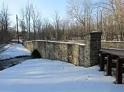 Salisbury Turnpike Bridge |
July 9, 1987 (#87001100) |
Old Turnpike Rd. 41°56′20″N 73°52′46″W / 41.938889°N 73.879444°W |
Rhinebeck | |
| 30 | Sipperly Lown Farmhouse | 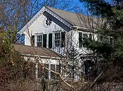 Sipperly Lown Farmhouse |
July 9, 1987 (#87001101) |
US 9 41°57′57″N 73°53′08″W / 41.965833°N 73.885556°W |
Rhinebeck | 19th-century farm complex with Dutch barn and eclectic Victorian 1868 farmhouse |
| 31 | Sixteen Mile District | 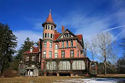 Sixteen Mile District |
March 7, 1979 (#79001571) |
W of Clermont along Hudson River 41°57′12″N 73°55′29″W / 41.953333°N 73.924722°W |
Rhinebeck | |
| 32 | Slate Quarry Road Dutch Barn | 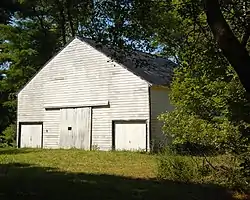 Slate Quarry Road Dutch Barn |
July 9, 1987 (#87001077) |
Slate Quarry Rd. 41°54′39″N 73°51′32″W / 41.910833°N 73.858889°W |
Rhinebeck | |
| 33 | Steenburg Tavern | July 9, 1987 (#87001070) |
US 9 41°54′36″N 73°54′33″W / 41.91°N 73.909167°W |
Rhinebeck | ||
| 34 | Stonecrest | 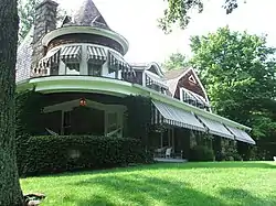 Stonecrest |
July 9, 1987 (#87001097) |
Old Post Rd. 41°52′33″N 73°54′49″W / 41.875833°N 73.913611°W |
Rhinebeck | |
| 35 | Strawberry Hill |  Strawberry Hill |
July 9, 1987 (#87001071) |
Ackert Hook Rd. 41°52′58″N 73°53′02″W / 41.882778°N 73.883889°W |
Rhinebeck | Built in 1762. Sold to George Adam Asher by Henry Beekman in 1774. It was later the home of A.D. Rothman, a White House news correspondent. |
| 36 | Traver House | 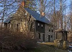 Traver House |
July 9, 1987 (#87001069) |
Wynkoop Ln. 41°56′30″N 73°53′51″W / 41.941667°N 73.8975°W |
Rhinebeck | 1730 stone house, built into hillside, expanded in 1790 |
| 37 | J. E. Traver Farm |  J. E. Traver Farm |
July 9, 1987 (#87001082) |
Violet Hill Rd. 41°55′34″N 73°52′31″W / 41.926111°N 73.875278°W |
Rhinebeck | |
| 38 | US Post Office-Rhinebeck | 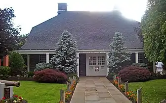 US Post Office-Rhinebeck |
May 11, 1989 (#88002419) |
6383 Mill St.[5] 41°55′34″N 73°54′49″W / 41.926111°N 73.913611°W |
Rhinebeck | Built in imitation of Beekman House under the direction of then-President Franklin D. Roosevelt |
| 39 | Van Vredenburg Farm | 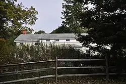 Van Vredenburg Farm |
July 9, 1987 (#87001079) |
57 Cedar Heights Rd. 41°57′07″N 73°52′45″W / 41.9520°N 73.8791°W |
Rhinebeck | |
| 40 | Williams Farm | 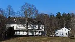 Williams Farm |
July 9, 1987 (#87001080) |
Enterprise Rd. 41°56′09″N 73°50′08″W / 41.935833°N 73.835556°W |
Rhinebeck | Farm centered around 1835 Greek Revival house |
Former listings
| [3] | Name on the Register | Image | Date listed | Date removed | Location | Description |
|---|---|---|---|---|---|---|
| 1 | Robert Sands Estate | February 24, 1975 (#75001183) | August 3, 2015 | 1.5 mi (2.4 km). E of Rhinebeck at NY 308 and NY 9 41°56′06″N 73°52′40″W / 41.935°N 73.877778°W |
Only foundations remain after 1999 fire |
See also
Wikimedia Commons has media related to National Register of Historic Places in Rhinebeck, New York.
References
- ↑ The latitude and longitude information provided in this table was derived originally from the National Register Information System, which has been found to be fairly accurate for about 99% of listings. Some locations in this table may have been corrected to current GPS standards.
- ↑ National Park Service, United States Department of the Interior, "National Register of Historic Places: Weekly List Actions", retrieved January 5, 2024.
- 1 2 Numbers represent an alphabetical ordering by significant words. Various colorings, defined here, differentiate National Historic Landmarks and historic districts from other NRHP buildings, structures, sites or objects.
- ↑ The eight-digit number below each date is the number assigned to each location in the National Register Information System database, which can be viewed by clicking the number.
- ↑ Address based on USPS website. Accessed March 31, 2016.

This article is issued from Wikipedia. The text is licensed under Creative Commons - Attribution - Sharealike. Additional terms may apply for the media files.