
Location of East Feliciana Parish in Louisiana
This is a list of the National Register of Historic Places listings in East Feliciana Parish, Louisiana.
This is intended to be a complete list of the properties and districts on the National Register of Historic Places in East Feliciana Parish, Louisiana, United States. The locations of National Register properties and districts for which the latitude and longitude coordinates are included below, may be seen in a map.[1]
There are 32 properties and districts listed on the National Register in the parish, including 2 National Historic Landmarks.
This National Park Service list is complete through NPS recent listings posted January 5, 2024.[2]
Current listings
| [3] | Name on the Register[4] | Image | Date listed[5] | Location | City or town | Description |
|---|---|---|---|---|---|---|
| 1 | 1903 Clinton High School | 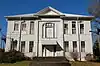 1903 Clinton High School |
June 1, 2005 (#05000505) |
11048 Bank Street 30°51′47″N 91°01′10″W / 30.86302°N 91.01935°W |
Clinton | |
| 2 | 1938 Clinton High School | 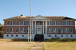 1938 Clinton High School |
June 1, 2005 (#05000506) |
10410 Plank Road 30°51′45″N 91°00′50″W / 30.86244°N 91.01376°W |
Clinton | Classical Revival school designed by Herman J. Duncan |
| 3 | Asphodel Plantation and Cemetery | November 15, 1972 (#72000552) |
About 3.5 miles (5.6 km) south of Jackson on LA 68 30°47′12″N 91°13′02″W / 30.78678°N 91.21734°W |
Jackson | ||
| 4 | Avondale Plantation Home | December 17, 1982 (#82000434) |
Along Andrews Road, about 0.87 miles (1.40 km) southeast of LA 10 30°51′47″N 90°59′10″W / 30.86299°N 90.98601°W |
Clinton | ||
| 5 | Bank of Slaughter | 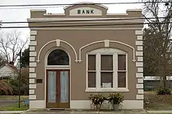 Bank of Slaughter |
May 6, 2005 (#05000369) |
3323 Church Street 30°43′04″N 91°08′40″W / 30.71786°N 91.14444°W |
Slaughter | |
| 6 | Boatner House | 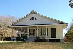 Boatner House |
May 31, 1980 (#80001719) |
Corner of Plank Road and Taylor Street 30°51′49″N 91°00′54″W / 30.8636°N 91.01506°W |
Clinton | |
| 7 | Brame-Bennett House | 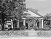 Brame-Bennett House |
May 22, 1973 (#73000866) |
Along Plank Road, directly opposite Boatner House 30°51′49″N 91°00′57″W / 30.86358°N 91.01572°W |
Clinton | |
| 8 | Carroll House | 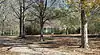 Carroll House |
June 29, 1998 (#98000679) |
9553 Bank Street Extension 30°50′03″N 91°00′46″W / 30.83427°N 91.01266°W |
Clinton | |
| 9 | Centenary College | Centenary College |
April 19, 1979 (#79001062) |
Along College Street 30°50′33″N 91°12′41″W / 30.84255°N 91.2114°W |
Jackson | Now a Louisiana State historic site operated as Centenary State Historic Site. Also a contributing property to Jackson Historic District since its creation on December 4, 1980. |
| 10 | Center Building of East Louisiana State Hospital | 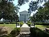 Center Building of East Louisiana State Hospital |
August 1, 1980 (#80001721) |
Southeast of Jackson on LA 951 30°49′59″N 91°12′47″W / 30.83307°N 91.21293°W |
Jackson | |
| 11 | Clear Creek AME Church | 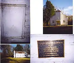 Clear Creek AME Church |
March 28, 2002 (#02000269) |
Along LA 961, about 0.37 miles (0.60 km) south of Felixville 30°56′13″N 90°52′38″W / 30.9369°N 90.8773°W |
Felixville | |
| 12 | Courthouse and Lawyers' Row | .jpg.webp) Courthouse and Lawyers' Row |
May 30, 1974 (#74002249) |
Bounded by Liberty Street, St. Helena Street, Bank Street, and Woodville Street 30°51′59″N 91°01′06″W / 30.86651°N 91.01843°W |
Clinton | |
| 13 | East Feliciana Parish Courthouse | 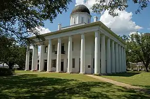 East Feliciana Parish Courthouse |
June 4, 1973 (#73002232) |
Public Square 30°51′58″N 91°01′06″W / 30.86622°N 91.0184°W |
Clinton | Also a contributing property to Courthouse and Lawyers' Row National Historic Landmark District since its creation on May 30, 1974. |
| 14 | Fairview Plantation House | August 12, 1993 (#93000821) |
8338 LA 963, about 4.4 miles (7.1 km) west of Clinton 30°51′48″N 91°05′31″W / 30.863333°N 91.091944°W |
Ethel | Also known as Lakeview | |
| 15 | Heyman-Stewart House |  Heyman-Stewart House |
November 9, 2001 (#01001211) |
10943 Bank Street 30°51′41″N 91°01′07″W / 30.86146°N 91.01854°W |
Clinton | |
| 16 | Holly Grove | February 14, 1997 (#97000058) |
10929 Rouchon Lane 30°55′43″N 90°56′59″W / 30.92857°N 90.94961°W |
Clinton | ||
| 17 | Hope Terrace | 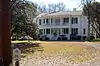 Hope Terrace |
August 13, 1986 (#86001493) |
Corner of Church Street and Silliman Street 30°51′35″N 91°00′58″W / 30.85983°N 91.01616°W |
Clinton | |
| 18 | Jackson Historic District |  Jackson Historic District |
December 4, 1980 (#80001722) |
Roughly bounded by College Street, LA 952, Horton Street and Race Street 30°50′21″N 91°12′56″W / 30.83917°N 91.21544°W |
Jackson | |
| 19 | Lane Plantation House | April 22, 1993 (#93000322) |
7684 Lane Road, about 3.2 miles (5.1 km) northeast of Ethel 30°48′32″N 91°04′54″W / 30.80895°N 91.08176°W |
Ethel | ||
| 20 | Linwood | 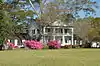 Linwood |
June 9, 1980 (#80001723) |
End of Dougherty Road, about 7.8 miles (12.6 km) south of Jackson 30°43′28″N 91°13′52″W / 30.72453°N 91.23103°W |
Jackson | |
| 21 | Marston House | 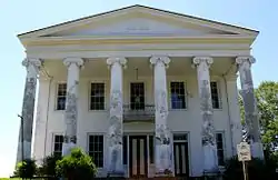 Marston House |
June 29, 1972 (#72000551) |
Northwest corner of Bank Street and Marston Street 30°51′44″N 91°01′09″W / 30.86217°N 91.01921°W |
Clinton | |
| 22 | Oakland Plantation House | October 3, 1980 (#80001720) |
Along LA 963, about 0.63 miles (1.01 km) west of Gurley 30°52′18″N 91°08′41″W / 30.87157°N 91.14464°W |
Gurley | ||
| 23 | Port Hudson | 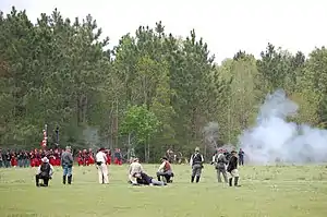 Port Hudson |
May 30, 1974 (#74002349) |
Port Hudson and nearby area along US 61 30°41′36″N 91°16′33″W / 30.6933°N 91.27585°W |
Port Hudson | Site of the longest siege in U.S. history, 1863's Siege of Port Hudson during the American Civil War. |
| 24 | Richland Plantation | March 28, 1979 (#79001064) |
7240 Azalea Street (LA 422), about 4.4 miles (7.1 km) east of Norwood, Louisiana 30°59′20″N 91°02′03″W / 30.98883°N 91.03408°W |
Norwood | ||
| 25 | St. Andrew's Episcopal Church | 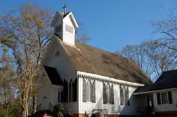 St. Andrew's Episcopal Church |
June 21, 1984 (#84001282) |
11015 Church Street 30°51′44″N 91°00′58″W / 30.86215°N 91.01601°W |
Clinton | |
| 26 | The Shades | November 6, 1980 (#80001724) |
About 6 miles (9.7 km) northeast of Jackson 30°54′29″N 91°09′26″W / 30.9081°N 91.15728°W |
Jackson | ||
| 27 | Silliman Institute | 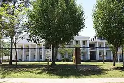 Silliman Institute |
April 18, 1983 (#83000504) |
10830 Bank Street 30°51′33″N 91°01′11″W / 30.85913°N 91.01961°W |
Clinton | |
| 28 | Taylor House | December 8, 1997 (#97001518) |
In Villa Feliciana Hospital grounds, about 850 yards (780 m) north of LA 10 30°50′12″N 91°09′27″W / 30.83662°N 91.15738°W |
Jackson | Also known as Woodlawn. | |
| 29 | Thompson House | September 29, 1980 (#80001725) |
Along LA 68, about 5.2 miles (8.4 km) northeast of Jackson 30°53′25″N 91°09′20″W / 30.89026°N 91.15558°W |
Jackson | Also known as Glencoe and Westerfields. | |
| 30 | Wall House | 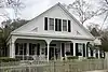 Wall House |
May 31, 1984 (#84001285) |
Woodville Street 30°52′01″N 91°00′49″W / 30.86707°N 91.01374°W |
Clinton | |
| 31 | Wildwood Plantation House | June 30, 1988 (#88000977) |
Along LA 68, about 9.6 miles (15.4 km) south of Jackson 30°42′09″N 91°15′41″W / 30.7026°N 91.26147°W |
Jackson | ||
| 32 | Woodside | 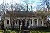 Woodside |
October 4, 1984 (#84000012) |
12415 St. Helena Street 30°51′56″N 91°00′58″W / 30.86560°N 91.01619°W |
Clinton |
See also
Wikimedia Commons has media related to National Register of Historic Places in East Feliciana Parish, Louisiana.
References
- ↑ The latitude and longitude information provided in this table was derived originally from the National Register Information System, which has been found to be fairly accurate for about 99% of listings. Some locations in this table may have been corrected to current GPS standards.
- ↑ National Park Service, United States Department of the Interior, "National Register of Historic Places: Weekly List Actions", retrieved January 5, 2024.
- ↑ Numbers represent an alphabetical ordering by significant words. Various colorings, defined here, differentiate National Historic Landmarks and historic districts from other NRHP buildings, structures, sites or objects.
- ↑ "National Register Information System". National Register of Historic Places. National Park Service. March 13, 2009.
- ↑ The eight-digit number below each date is the number assigned to each location in the National Register Information System database, which can be viewed by clicking the number.

Municipalities and communities of East Feliciana Parish, Louisiana, United States | ||
|---|---|---|
| Towns | | |
| Villages | ||
| Unincorporated communities | ||
This article is issued from Wikipedia. The text is licensed under Creative Commons - Attribution - Sharealike. Additional terms may apply for the media files.