
Location of Clark County in Ohio
This is a list of the National Register of Historic Places listings in Clark County, Ohio.
This is intended to be a complete list of the properties and districts on the National Register of Historic Places in Clark County, Ohio, United States. The locations of National Register properties and districts for which the latitude and longitude coordinates are included below, may be seen in an online map.[1]
There are 42 properties and districts listed on the National Register in the county.
This National Park Service list is complete through NPS recent listings posted January 5, 2024.[2]
Current listings
| [3] | Name on the Register[4] | Image | Date listed[5] | Location | City or town | Description |
|---|---|---|---|---|---|---|
| 1 | Arcade Hotel | .jpg.webp) Arcade Hotel |
October 16, 1974 (#74001410) |
Fountain Ave. and High St. 39°55′21″N 83°48′36″W / 39.9225°N 83.81°W |
Springfield | |
| 2 | Francis Bookwalter House | 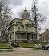 Francis Bookwalter House |
January 3, 1980 (#80002954) |
611 S. Fountain Ave. 39°55′02″N 83°48′40″W / 39.917222°N 83.811111°W |
Springfield | |
| 3 | Brewer Log House | 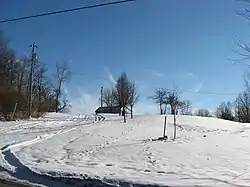 Brewer Log House |
August 13, 1974 (#74001411) |
2665 Old Springfield Rd., south of Springfield 39°51′03″N 83°45′53″W / 39.850833°N 83.764722°W |
Green Township | |
| 4 | David Crabill House | 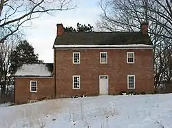 David Crabill House |
October 10, 1975 (#75001341) |
5 mi (8.0 km) east of Springfield off State Route 4 39°57′39″N 83°44′52″W / 39.960833°N 83.747778°W |
Moorefield Township | |
| 5 | East High Street District | 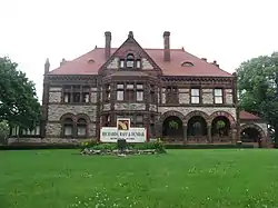 East High Street District |
October 9, 1974 (#74001412) |
Roughly bounded by E. High, S. Sycamore, and Walnut Sts. 39°55′18″N 83°47′48″W / 39.921667°N 83.796667°W |
Springfield | |
| 6 | Enon Mound | 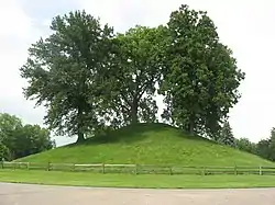 Enon Mound |
February 23, 1972 (#72001005) |
Mound Circle in central Enon[6] 39°52′46″N 83°55′54″W / 39.879583°N 83.931667°W |
Enon | Probably built by the Adena culture.[7] |
| 7 | Green Plain Monthly Meetinghouse | 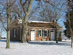 Green Plain Monthly Meetinghouse |
April 1, 1982 (#82003551) |
Clifton Rd., southwest of South Charleston 39°48′35″N 83°41′28″W / 39.809722°N 83.691111°W |
Madison Township | |
| 8 | Daniel Hertzler House | 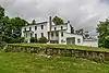 Daniel Hertzler House |
February 7, 1978 (#78002018) |
West of Springfield off State Route 4 39°54′33″N 83°54′40″W / 39.909167°N 83.911111°W |
Bethel Township | |
| 9 | Kenton-Hunt Farm |  Kenton-Hunt Farm |
February 8, 1980 (#80002955) |
North of Springfield at 4690 Urbana Rd. 39°59′33″N 83°48′13″W / 39.992383°N 83.803717°W |
Moorefield Township | |
| 10 | Lagonda Club Building |  Lagonda Club Building |
May 28, 1975 (#75001342) |
Northwestern corner of High and Spring Sts. 39°55′24″N 83°48′25″W / 39.923333°N 83.807°W |
Springfield | |
| 11 | Lagonda National Bank | 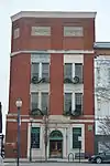 Lagonda National Bank |
July 3, 2017 (#100001267) |
2 E. Main St. 39°55′29″N 83°48′36″W / 39.924722°N 83.810000°W |
Springfield | |
| 12 | Main Street Buildings | 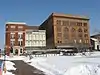 Main Street Buildings |
March 2, 1979 (#79001790) |
6-14 E. Main St. 39°55′28″N 83°48′35″W / 39.924444°N 83.809722°W |
Springfield | |
| 13 | Marquart-Mercer Farm | 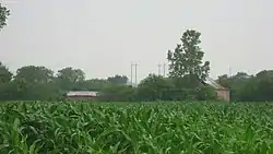 Marquart-Mercer Farm |
July 26, 1979 (#79001791) |
Southwest of Springfield 39°51′21″N 83°49′47″W / 39.855833°N 83.829722°W |
Mad River Township | |
| 14 | Masonic Temple | 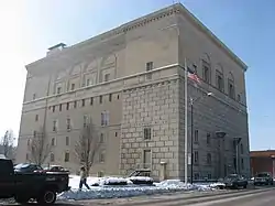 Masonic Temple |
December 17, 2008 (#08001195) |
125 W. High St. 39°55′24″N 83°48′48″W / 39.923333°N 83.813333°W |
Springfield | |
| 15 | Municipal Building | 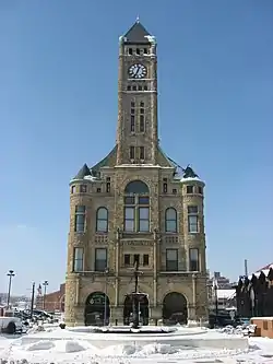 Municipal Building |
May 25, 1973 (#73001394) |
S. Fountain Ave. between High and Washington Sts. 39°55′23″N 83°48′40″W / 39.923056°N 83.811111°W |
Springfield | |
| 16 | Myers Daily Market | February 14, 2018 (#100002119) |
101 S. Fountain Ave. 39°55′23″N 83°48′38″W / 39.923099°N 83.810448°W |
Springfield | ||
| 17 | Myers Hall |  Myers Hall |
June 30, 1975 (#75001343) |
Wittenberg Ave. and Ward St. 39°56′05″N 83°48′50″W / 39.934722°N 83.813889°W |
Springfield | |
| 18 | Newlove Works | 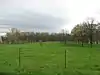 Newlove Works |
June 4, 1973 (#73001395) |
Along Newlove Road in Section 29 of Harmony Township[8] 39°55′11″N 83°40′18″W / 39.919722°N 83.671667°W |
Harmony Township | |
| 19 | Odd Fellows' Home for Orphans, Indigent and Aged |  Odd Fellows' Home for Orphans, Indigent and Aged |
April 16, 1980 (#80002956) |
404 E. McCreight Ave. 39°56′18″N 83°48′06″W / 39.938447°N 83.801667°W |
Springfield | |
| 20 | Old Enon Road Stone Arch Culvert | 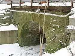 Old Enon Road Stone Arch Culvert |
April 16, 2009 (#09000209) |
Rocky Point Rd., approximately 185 feet west of Old Mill Rd. 39°52′10″N 83°52′46″W / 39.869544°N 83.879428°W |
Mad River Township | |
| 21 | Olive Branch High School |  Olive Branch High School |
July 23, 2009 (#09000563) |
9710 W. National Rd., southeast of New Carlisle 39°54′48″N 83°59′36″W / 39.913333°N 83.993333°W |
Bethel Township | |
| 22 | Ollie's Tavern | 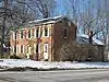 Ollie's Tavern |
January 25, 1997 (#96001619) |
10516 Marquart Rd., north of New Carlisle 39°58′59″N 84°00′08″W / 39.983056°N 84.002222°W |
Pike Township | |
| 23 | Pennsylvania House |  Pennsylvania House |
April 11, 1973 (#73001396) |
1311 W. Main St. 39°55′32″N 83°49′58″W / 39.925556°N 83.832778°W |
Springfield | |
| 24 | Pickaway Settlements Battlesite | 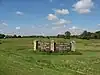 Pickaway Settlements Battlesite |
May 8, 1980 (#80002953) |
North of Enon 39°54′27″N 83°55′15″W / 39.9075°N 83.920833°W |
Bethel Township | |
| 25 | Pringle-Patric House | 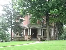 Pringle-Patric House |
December 15, 1997 (#97001547) |
1314-1316 E. High St. 39°55′16″N 83°47′24″W / 39.921111°N 83.79°W |
Springfield | |
| 26 | C.A. Reeser House |  C.A. Reeser House |
June 20, 1980 (#80002957) |
1425 Innisfallen Ave. 39°54′51″N 83°50′07″W / 39.914167°N 83.835278°W |
Springfield | Destroyed |
| 27 | St. John's Evangelical Lutheran Church | 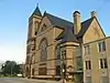 St. John's Evangelical Lutheran Church |
June 7, 2006 (#06000485) |
27 N. Wittenberg Ave. 39°55′33″N 83°48′51″W / 39.9258°N 83.814147°W |
Springfield | |
| 28 | St. Joseph Roman Catholic Church |  St. Joseph Roman Catholic Church |
March 15, 1982 (#82003552) |
802 Kenton St. 39°54′57″N 83°47′52″W / 39.915833°N 83.797778°W |
Springfield | |
| 29 | St. Raphael Church | 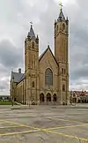 St. Raphael Church |
June 22, 1976 (#76001381) |
225 E. High St. 39°55′22″N 83°48′23″W / 39.922778°N 83.806389°W |
Springfield | |
| 30 | Shawnee Hotel | 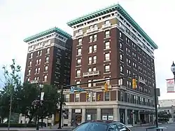 Shawnee Hotel |
December 5, 1985 (#85003044) |
Main and Limestone Sts. 39°55′29″N 83°48′30″W / 39.924722°N 83.808278°W |
Springfield | |
| 31 | South Charleston Historic District | 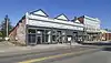 South Charleston Historic District |
July 17, 1978 (#78002017) |
Centered on Jamestown and Chillicothe Sts.[9] 39°49′30″N 83°38′04″W / 39.8250°N 83.6344°W |
South Charleston | |
| 32 | South Fountain Avenue Historic District | 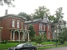 South Fountain Avenue Historic District |
December 29, 1983 (#83004114) |
Roughly Fountain Ave. and Limestone St. from Perrin to Monroe Sts. 39°54′53″N 83°48′40″W / 39.9148°N 83.8111°W |
Springfield | |
| 33 | Springfield Country Club | October 30, 2023 (#100009480) |
2315 Signal Hill Rd 39°57′19″N 83°48′37″W / 39.9552°N 83.8102°W |
Springfield | ||
| 34 | Springfield Downtown Historic District | January 25, 2021 (#100006049) |
Roughly bounded by Columbia, Fountain, Main, and Limestone streets 39°55′30″N 83°48′33″W / 39.9251°N 83.8093°W |
Springfield | ||
| 35 | Springfield Metallic Casket Company | 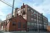 Springfield Metallic Casket Company |
February 23, 2016 (#16000040) |
105 N. Center St. 39°55′36″N 83°48′43″W / 39.9267°N 83.8119°W |
Springfield | |
| 36 | Tecumseh Building | 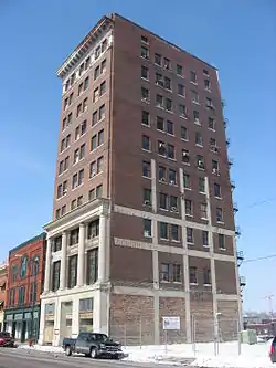 Tecumseh Building |
December 28, 2000 (#00001555) |
34 W. High St. 39°55′25″N 83°48′42″W / 39.9236°N 83.8117°W |
Springfield | |
| 37 | Third Presbyterian Church | 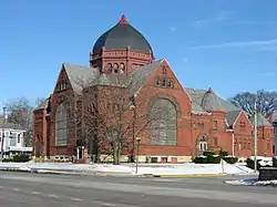 Third Presbyterian Church |
January 3, 1980 (#80002958) |
714 N. Limestone St. 39°55′58″N 83°48′20″W / 39.9328°N 83.8056°W |
Springfield | |
| 38 | Thomas Manufacturing Company Warehouse | 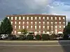 Thomas Manufacturing Company Warehouse |
February 2, 2001 (#01000055) |
360 S. Limestone St. 39°55′12″N 83°48′30″W / 39.92°N 83.8083°W |
Springfield | |
| 39 | Warder Public Library |  Warder Public Library |
February 17, 1978 (#78002019) |
E. High and Spring Sts. 39°55′21″N 83°48′26″W / 39.9225°N 83.8072°W |
Springfield | A gift of local businessman Benjamin Warder, it now houses the Warder Literacy Center after the main branch of Clark County Public Library was moved to a modern facility in 1989.[10] |
| 40 | Westcott House | 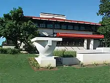 Westcott House |
July 24, 1974 (#74001413) |
1340 E. High St. 39°55′17″N 83°47′21″W / 39.9214°N 83.7892°W |
Springfield | The only Frank Lloyd Wright-designed Prairie School house in Ohio |
| 41 | Wittenberg University Historic District |  Wittenberg University Historic District |
March 4, 2014 (#14000040) |
Roughly bounded by Bill Edwards Dr., N. Fountain, W. Ward, and Plum 39°56′03″N 83°48′47″W / 39.9342°N 83.8131°W |
Springfield | |
| 42 | Edward Wren Company Building | 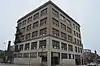 Edward Wren Company Building |
December 13, 2016 (#16000844) |
31-37 High St. 39°55′23″N 83°48′32″W / 39.9231°N 83.8089°W |
Springfield |
See also
Wikimedia Commons has media related to National Register of Historic Places in Clark County, Ohio.
- List of National Historic Landmarks in Ohio
- Listings in neighboring counties: Champaign, Greene, Madison, Miami, Montgomery
- National Register of Historic Places listings in Ohio
References
- ↑ The latitude and longitude information provided in this table was derived originally from the National Register Information System, which has been found to be fairly accurate for about 99% of listings. Some locations in this table may have been corrected to current GPS standards.
- ↑ National Park Service, United States Department of the Interior, "National Register of Historic Places: Weekly List Actions", retrieved January 5, 2024.
- ↑ Numbers represent an alphabetical ordering by significant words. Various colorings, defined here, differentiate National Historic Landmarks and historic districts from other NRHP buildings, structures, sites or objects.
- ↑ "National Register Information System". National Register of Historic Places. National Park Service. April 24, 2008.
- ↑ The eight-digit number below each date is the number assigned to each location in the National Register Information System database, which can be viewed by clicking the number.
- ↑ Location derived from this Ohio Historical Society webpage; the NRIS lists the site as "Address Restricted"
- ↑ Enon Mound, Ohio Historical Society, 2010. Accessed 9 February 2010.
- ↑ Location derived from Mills, William C. Archeological Atlas of Ohio. Columbus: Ohio State Archeological and Historical Society, 1914, page 7 and plate 7. The NRIS lists the site as "Address Restricted".
- ↑ Location derived from South Charleston Historic District, Ohio Historical Society, 2007, accessed 2010-12-28. The NRIS lists it at the nonexistent "State Route 70".
- ↑ Library History Archived 2010-01-22 at the Wayback Machine, Clark County Public Library, 2005. Accessed 9 February 2010.

Municipalities and communities of Clark County, Ohio, United States | ||
|---|---|---|
| Cities | Map of Ohio highlighting Clark County | |
| Villages | ||
| Townships | ||
| CDPs | ||
| Unincorporated communities | ||
| Ghost towns | ||
| Footnotes | ‡This populated place also has portions in an adjacent county or counties | |
This article is issued from Wikipedia. The text is licensed under Creative Commons - Attribution - Sharealike. Additional terms may apply for the media files.