| Moose Jaw River | |
|---|---|
 Moose Jaw River | |
 The Red River drainage basin, with the Qu'Appelle River highlighted | |
 Location of mouth in Saskatchewan  Moose Jaw River (Canada) | |
| Location | |
| Country | Canada |
| Provinces | |
| Physical characteristics | |
| Source | Ibsen Lake |
| • coordinates | 49°47′0″N 104°15′22″W / 49.78333°N 104.25611°W |
| • elevation | 575 m (1,886 ft) |
| Mouth | Qu'Appelle River |
• location | Buffalo Pound Provincial Park |
• coordinates | 50°34′04″N 105°17′42″W / 50.5679°N 105.2949°W |
| Basin size | 9,360 km2 (3,610 sq mi) |
| Basin features | |
| River system | Red River drainage basin |
| Tributaries | |
| • left | Avonlea Creek, Thunder Creek |
Moose Jaw River[1] is a river in the Canadian province of Saskatchewan. It is located in the southern part of the province in a region called the Prairie Pothole Region of North America, which extends throughout three Canadian provinces and five U.S. states. It is also within Palliser's Triangle and the Great Plains ecoregion.[2]
The Moose Jaw River drainage basin is one of five sub-basins that make up the Upper Qu'Appelle Watershed.[3] Craven Dam at the village of Craven is the dividing point between the upper and lower watersheds of the Qu'Appelle River. The river and its tributaries drain a total of 9,360 square kilometres (3,610 sq mi).[4] The total combined drainage area for the five sub-basins of the Upper Qu'Appelle Watershed is 23,443 square kilometres (9,051 sq mi).[5] The Qu'Appelle River system is part of the much larger Hudson Bay drainage basin.
Course
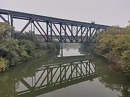
The source of the Moose Jaw River is Ibsen Lake,[6] which is about 6.4 kilometres (4.0 mi) west of Yellow Grass. From there, the river travels in a north-westerly direction following Highway 39 most of the way to the city of Moose Jaw. As the river reaches the city, it travels through the Wakamow Valley Park[7] before meeting Thunder Creek. From there, it heads east and then north where it meets the Qu'Appelle River about 3.2 kilometres (2.0 mi) east and downstream of Buffalo Pound Lake in the Nicolle Flats Marsh at the eastern end of Buffalo Pound Provincial Park. Several highways cross the river's path, including Highways 6, 334, 623, 339, 2, 1, and 301.
Tributaries
There are two main tributaries of the Moose Jaw River. Avonlea Creek[8] begins near the Piapot Cree First Nation 75G and flows in a north-west direction paralleling Moose Jaw River until near the village of Avonlea where it turns north and meets Moose Jaw River about 6.4 kilometres (4.0 mi) south-west of Rouleau. Along the course of Avonlea Creek is Watson Reservoir,[9] which is about 6.4 kilometres (4.0 mi) south-east of the town of Avonlea. At the north end of the reservoir is Dunnet Regional Park.[10]
The other main tributary is Thunder Creek.[11] Thunder Creek begins near Lake Diefenbaker and travels in a south-easterly direction and meets up with the Moose Jaw River in the city of Moose Jaw. There are four shallow, marshy lakes, Paysen (Horfield), Kettlehut, Williams, and Pelican along Thunder Creek's course and four main tributaries, Allin Creek, Aquadell Creek, Sandy Creek, and Wilson Creek.[12]
See also
References
- ↑ "Moose Jaw River". Canadian Geographical Names Database. Government of Canada. Retrieved 30 November 2022.
- ↑ "Drought in Palliser's Triangle | the Canadian Encyclopedia".
- ↑ "Our Watershed". WUQWATR. Retrieved 19 September 2021.
- ↑ Caring for Our Watersheds. (n.d.). Watershed information. Retrieved from https://caringforourwatersheds.com/canada/saskatchewan/watershed-information/
- ↑ "Our Watershed". WUQWATR. Retrieved 17 September 2021.
- ↑ "Isben Lake". Canadian Geographical Names Database. Government of Canada. Retrieved 20 December 2022.
- ↑ "Wakamow Valley". Tourism Saskatchewan. Government of Saskatchewan. Retrieved 31 October 2023.
- ↑ "Avonlea Creek". Canadian Geographical Names Database. Government of Canada. Retrieved 20 December 2022.
- ↑ "Angler's Atlas".
- ↑ "Dunnet".
- ↑ "Thunder Creek". Canadian Geographical Names Database. Government of Canada. Retrieved 20 December 2022.
- ↑ "Our Watershed". Moose Jaw River. Moose Jaw River Watershed Stewards. Retrieved 29 December 2022.
External links
 Media related to Moose Jaw River at Wikimedia Commons