Mempawah Regency
Kabupatan Mempawah | |
|---|---|
 Coat of arms | |
| Motto(s): Maju dengan Ilmu Forward with knowledge | |
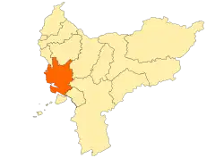 Location within West Kalimantan | |
 Mempawah Regency Location in Kalimantan and Indonesia 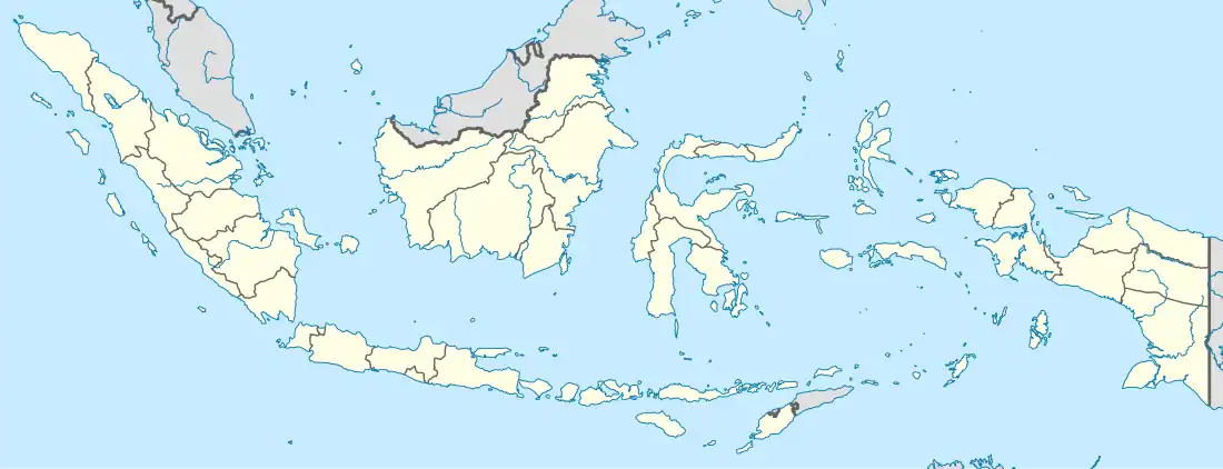 Mempawah Regency Mempawah Regency (Indonesia) | |
| Coordinates: 0°15′00″N 109°10′00″E / 0.2500°N 109.1667°E | |
| Country | Indonesia |
| Province | West Kalimantan |
| Capital | Mempawah |
| Government | |
| • Regent | Erlina |
| • Vice Regent | Muhammad Pagi |
| Area | |
| • Total | 1,276.90 km2 (493.01 sq mi) |
| Population (mid 2022 estimate)[1] | |
| • Total | 310,927 |
| • Density | 240/km2 (630/sq mi) |
| Time zone | UTC+7 (IWST) |
| Area code | (+62) 561 |
| Website | mempawahkab |
Mempawah Regency (formerly called the Pontianak Regency) is a regency of West Kalimantan Province of Indonesia. Originally including a wider area of West Kalimantan, this Pontianak Regency was reduced on 4 October 1999 by the north-eastern districts (formerly the majority of the regency's land area) being removed to form a new Landak Regency, and was further reduced on 17 July 2007 by its southern districts cut out to create a new Kubu Raya Regency. Since 2007 it covers 2,797.88 km2, and had a population of 234,021 at the 2010 Census[2] and 301,560 at the 2020 Census;[3] the official estimate as at mid 2022 was 310,927 (comprising 158,866 males and 52,061 females).[1] The principal town lies at Mempawah.
History
Based on Government Regulation No. 58 of 2014 (Peraturan Pemerintah Nomor 58 Tahun 2014), Pontianak Regency was formally renamed Mempawah Regency.[4]
Administrative Districts
Since the separation of the southern parts of the former Pontianak Regency on 17 July 2007 to form the new Kubu Raya Regency, the residual area - in 2014 renamed as Mempawah Regency - consists of nine districts (kecamatan), tabulated below with their areas and their populations at the 2010 Census[2] and the 2020 Census,[3] together with the official estimates as at mid 2022.[1] The table also includes the locations of the district administrative centres, the number of administrative villages in each district (a total of 60 rural desa and 7 urban kelurahan), and its post code.
| Kode Wilayah | Name of District (kecamatan) |
Year formed | Area in km2 | Pop'n Census 2010 | Pop'n Census 2020 | Pop'n Estimate mid 2022 | Admin centre | No. of villages | Post code |
|---|---|---|---|---|---|---|---|---|---|
| 61.02.08 | Siantan (Jongkat) | — | 408.26 | 40,360 | 50,275 | 51,493 | Jungkat | 5 | 78352 |
| 61.02.15 | Segedong | 2007 (from Siantan) | 260.60 | 20,249 | 26,149 | 26,970 | Parit Bugis | 6 | 78351 |
| 61.02.07 | Sungai Pinyuh (Pinyuh River) |
— | 265.84 | 47,311 | 61,352 | 63,331 | Sungai Pinyuh | 9 | 78354 |
| 61.02.16 | Anjongan | 2005 (from Sungai Pinyuh) | 124.08 | 16,628 | 20,878 | 21,417 | Anjungan Melancar | 5 (1) | 78353 |
| 61.02.01 | Mempawah Hilir (Lower Mempawah) |
— | 398.42 | 34,328 | 44,936 | 46,469 | Terusan | 8 | 78911 -78919 |
| 61.02.18 | Mempawah Timur (East Mempawah) |
2006 (from Mempawah Hilir) | 199.45 | 25,220 | 33,761 | 35,064 | Antibar | 8 | 78915 & 78919 |
| 61.02.12 | Sungai Kunyit (Kunyit River) |
— | 442.79 | 22,069 | 28,380 | 29,248 | Sungai Kunyit Laut | 12 | 78371 |
| 61.02.06 | Toho | — | 244.87 | 17,724 | 23,613 | 24,502 | Toho | 8 | 78360 |
| 61.02.17 | Sadaniang | 2006 (from Toho) | 453.58 | 10,132 | 12,216 | 12,433 | Pentek | 6 | 78361 |
| Totals | 2,797.88 | 234,012 | 301,560 | 310,927 | Mempawah | 67 |
Climate
| Climate data for Mempawah (1991−2020 normals) | |||||||||||||
|---|---|---|---|---|---|---|---|---|---|---|---|---|---|
| Month | Jan | Feb | Mar | Apr | May | Jun | Jul | Aug | Sep | Oct | Nov | Dec | Year |
| Mean daily maximum °C (°F) | 31.0 (87.8) |
31.1 (88.0) |
31.4 (88.5) |
31.6 (88.9) |
31.8 (89.2) |
31.7 (89.1) |
31.6 (88.9) |
31.7 (89.1) |
31.5 (88.7) |
31.3 (88.3) |
31.1 (88.0) |
30.9 (87.6) |
31.4 (88.5) |
| Daily mean °C (°F) | 27.5 (81.5) |
27.6 (81.7) |
28.1 (82.6) |
28.6 (83.5) |
28.9 (84.0) |
28.7 (83.7) |
28.1 (82.6) |
28.3 (82.9) |
28.1 (82.6) |
27.9 (82.2) |
27.9 (82.2) |
27.7 (81.9) |
28.1 (82.6) |
| Mean daily minimum °C (°F) | 23.9 (75.0) |
23.9 (75.0) |
24.0 (75.2) |
24.2 (75.6) |
24.4 (75.9) |
24.2 (75.6) |
23.8 (74.8) |
23.8 (74.8) |
23.9 (75.0) |
24.0 (75.2) |
24.1 (75.4) |
24.1 (75.4) |
24.0 (75.2) |
| Average precipitation mm (inches) | 198.7 (7.82) |
131.9 (5.19) |
143.3 (5.64) |
193.6 (7.62) |
227.1 (8.94) |
189.3 (7.45) |
183.3 (7.22) |
136.5 (5.37) |
198.0 (7.80) |
252.2 (9.93) |
274.4 (10.80) |
280.8 (11.06) |
2,409.1 (94.85) |
| Average precipitation days (≥ 1.0 mm) | 15.2 | 11.3 | 12.0 | 14.2 | 14.6 | 12.3 | 11.5 | 9.8 | 12.6 | 18.0 | 19.2 | 18.6 | 169.3 |
| Source: World Meteorological Organization[5] | |||||||||||||
Gallery
 Emblem of the former Pontianak Regency (1963-2014). To prevent confusion with Pontianak City and the creation of Landak Regency and Kubu Raya Regency from its territory, the residual part of this regency was in 2014 renamed as Mempawah Regency.[6]
References
- 1 2 3 Badan Pusat Statistik, Jakarta, 2023, Kabupaten Mempawah Dalam Angka 2023 (Katalog-BPS 1102001.6102)
- 1 2 Biro Pusat Statistik, Jakarta, 2011.
- 1 2 Badan Pusat Statistik, Jakarta, 2021.
- ↑ "Nama Kabupaten Pontianak Resmi Diganti Jadi Kabupaten Mempawah". September 14, 2014.
- ↑ "World Meteorological Organization Climate Normals for 1991–2020". World Meteorological Organization. Retrieved 19 October 2023.
- ↑ "Siap Umumkan Nama Baru Daerah". www.mempawahkab.go.id.
Regencies and cities of West Kalimantan | ||
|---|---|---|
Capital: Pontianak | ||
| Regencies | ||
| Cities | ||