Marcy-Holmes | |
|---|---|
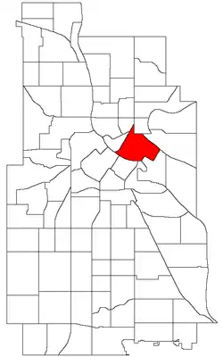 Location of Marcy-Holmes within the U.S. city of Minneapolis | |
| Country | United States |
| State | Minnesota |
| County | Hennepin |
| City | Minneapolis |
| Community | University |
| Area | |
| • Total | 0.825 sq mi (2.14 km2) |
| Population (2020)[2] | |
| • Total | 15,141 |
| • Density | 18,000/sq mi (7,100/km2) |
| Time zone | UTC-6 (CST) |
| • Summer (DST) | UTC-5 (CDT) |
| ZIP code | 55414 |
| Area code | 612 |
| Website | http://www.marcy-holmes.org |
| Census | Pop. | Note | %± |
|---|---|---|---|
| 1980 | 8,646 | — | |
| 1990 | 8,810 | 1.9% | |
| 2000 | 9,009 | 2.3% | |
| 2010 | 10,015 | 11.2% | |
| 2020 | 15,141 | 51.2% |
Marcy-Holmes is a neighborhood in the University community of Minneapolis. The majority of the area is residential and sits upon a bluff overlooking the river and the city skyline. However, a small section of the neighborhood along the river is an industrial zone.[3]
The neighborhood is bordered on the south by the Mississippi River, to the east by the University of Minnesota and 15th Avenue Southeast, to the north by the railroad tracks that separate it from the Como Neighborhood, and to the west by Central Avenue. Although somewhat confusing to newcomers, the Marcy-Holmes neighborhood is considered part of Southeast Minneapolis, despite its seemingly centralized location within the city today. Almost every street and avenue within the neighborhood is labeled "SE"- South of East Hennepin Avenue and East of the Mississippi River. Entirely within Minneapolis' Ward 3, Marcy-Holmes is represented by City Council member Michael Rainville. The neighborhood is named after Marcy Park and Holmes Park (themselves named in honor of William L. Marcy and Oliver Wendell Holmes) which are located within the neighborhood.
Marcy-Holmes is well known for its diverse community, its commercial districts, St. Anthony Main and Dinkytown, and its immediate proximity to the East Bank of the University of Minnesota-Twin Cities campus.
Demographics
In 2020, Marcy-Holmes had a population of 15,149.[4] About 80% of residents 5 and older speak English at home. 17.4% of residents are foreign born. Over 86% of households are renter-occupied.[5]
- White 71.9%
- Black 6.6%
- American Indian and Alaska Natives 0.6%
- Asian 10.3%
- Hispanic 5.3%
- Other 0.4%
- Two or more 4.8%
Landmarks
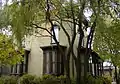
- B. O. Cutter House
- Marcy-Holmes Community Garden
- Stone Arch Bridge
- Sixth Avenue Gateway
- Florence Court
- Frey Mansion
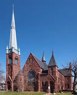
- First Congregational Church
Historic Districts
Image gallery
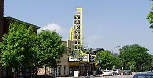 Varsity Theater
In popular culture
- Marcy Open School, located in the neighborhood, is the namesake for the band Marcy Playground, which the band's lead singer attended.
References
- ↑ "Marcy-Holmes neighborhood in Minneapolis, Minnesota (MN), 55414, 55455 detailed profile". City-Data. 2011. Retrieved 2013-11-12.
- ↑ "Marcy Holmes neighborhood data". Minnesota Compass. Retrieved 2023-04-02.
- ↑ "Marcy-Holmes Neighborhood Association". Marcy-Holmes Neighborhood Association. Retrieved 2021-11-09.
- ↑ Bureau, US Census (2022-04-26). "2020 Census Results". Census.gov. Retrieved 2022-09-01.
- ↑ "Marcy-Holmes". Minnesota Compass. Retrieved 2022-09-22.
- 1 2 3 4 "History". Marcy-Holmes Neighborhood Association. Retrieved 2020-04-25.
- ↑ Marcy-Holmes, Minneapolis, MN. Google Earth. Retrieved 2011-03-09.
- Marcy-Holmes, Minneapolis, MN. Google Earth. Retrieved 2011-03-09.
^ "Neighborhood Profile on the City of Minneapolis website".
External links
- Marcy-Holmes Neighborhood Association
- Marcy-Holmes Profile at City of Minneapolis website
- Marcy-Holmes at Placeography
- Florence Court profile, Minneapolis Heritage Preservation Commission
Places adjacent to Marcy-Holmes, Minneapolis | |
|---|---|