This is a list of listed buildings in the parish of Killin in Stirling, Scotland.
List
| Name | Location | Date Listed | Grid Ref. [note 1] | Geo-coordinates | Notes | LB Number [note 2] | Image |
|---|---|---|---|---|---|---|---|
| Killin, Kinnell, Yellow Cottage | 56°27′47″N 4°19′05″W / 56.463015°N 4.31797°W | Category C(S) | 8279 |  Upload Photo | |||
| Finlarig Castle | 56°28′30″N 4°18′54″W / 56.474986°N 4.315063°W | Category B | 8285 | Upload Photo | |||
| Crianlarich, Lochdochart, Lochdochart House, Bridge To East Over River Dochart | 56°24′47″N 4°31′47″W / 56.412986°N 4.529852°W | Category B | 6715 | Upload Photo | |||
| Crianlarich, Crianlarich Station, Engine Shed | 56°23′22″N 4°37′05″W / 56.389352°N 4.617967°W | Category C(S) | 50319 | Upload Photo | |||
| Kinnell, Kinnell House Steading | 56°28′01″N 4°18′34″W / 56.466894°N 4.309456°W | Category B | 13679 | Upload Photo | |||
| Killin, Main Street, Killin And Ardeonaig Parish Church (Church Of Scotland) Including Boundary Walls | 56°28′11″N 4°19′02″W / 56.469652°N 4.317254°W | Category B | 8248 | 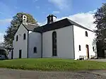
| |||
| Killin, Bridge Of Lochay Over River Lochay | 56°28′42″N 4°19′26″W / 56.478379°N 4.323941°W | Category B | 8261 | Upload Photo | |||
| Killin, Invertay House, Former Manse, Including Boundary Walls | 56°28′14″N 4°19′16″W / 56.470577°N 4.32111°W | Category C(S) | 8268 | Upload Photo | |||
| Breadalbane Mausoleum | 56°28′30″N 4°18′52″W / 56.475113°N 4.314518°W | Category C(S) | 8286 | Upload Photo | |||
| Glen Dochart, Near Suie, Macnabs Of Innishewan Burial Enclosure | 56°25′12″N 4°26′58″W / 56.420019°N 4.449484°W | Category C(S) | 8294 | Upload Photo | |||
| Tyndrum, Kirkton Farm, St Fillan's Graveyard | 56°25′10″N 4°39′40″W / 56.419315°N 4.661118°W | Category C(S) | 8297 | Upload Photo | |||
| Crianlarich, War Memorial | 56°23′35″N 4°37′08″W / 56.392981°N 4.618897°W | Category C(S) | 50321 | Upload Photo | |||
| Killin, James Stewart Memorial Including Railings | 56°28′11″N 4°19′04″W / 56.469705°N 4.317793°W | Category C(S) | 50327 | 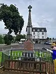
| |||
| Killin, Larachbeag, Station House And Tarmachan Teashop | 56°28′07″N 4°19′00″W / 56.468664°N 4.316707°W | Category C(S) | 50329 | Upload Photo | |||
| Tyndrum, Cononish House Including Byre To Rear And Boundary Walls | 56°25′02″N 4°45′15″W / 56.417182°N 4.754257°W | Category B | 50334 | Upload Photo | |||
| Auchlyne, Auchlyne House Walled Garden Including Kennels | 56°26′04″N 4°24′57″W / 56.43449°N 4.415929°W | Category C(S) | 13678 | Upload Photo | |||
| Killin, Main Street, Ashlea And Upper Ashlea Including Ancillary Building And Boundary Walls | 56°27′56″N 4°19′09″W / 56.465419°N 4.319188°W | Category C(S) | 8270 | 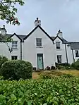
| |||
| Killin, Island Of Inchbuie (Innis Bhuidhe), Clan Macnab Burial Place Including Screen Wall And Gatepiers | 56°27′51″N 4°19′03″W / 56.464158°N 4.317374°W | Category B | 8277 | 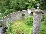
| |||
| Killin, Kinnell, Urn Gatepiers On West Drive (1St Of 4 Pairs) | 56°27′47″N 4°19′05″W / 56.463123°N 4.317944°W | Category C(S) | 8280 | Upload Photo | |||
| Inverarnan, Drover's Inn | 56°19′42″N 4°43′19″W / 56.32836°N 4.721806°W | Category B | 8288 | Upload Photo | |||
| Tyndrum Upper Railway Station Including Underpass And Former Signal Box | 56°26′05″N 4°42′14″W / 56.434678°N 4.703787°W | Category B | 8290 | Upload Photo | |||
| Killin, Main Street, St Fillan's Episcopal Church, Including Gates, Gatepiers And Boundary Walls | 56°28′08″N 4°19′00″W / 56.468941°N 4.316789°W | Category C(S) | 46364 | 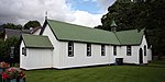
| |||
| Auchlyne Bridge Over River Dochart | 56°25′33″N 4°25′34″W / 56.425769°N 4.426241°W | Category B | 8266 | Upload Photo | |||
| Killin Parish Church Graveyard To North East Of Church Including Boundary Walls And Gates | 56°28′14″N 4°19′00″W / 56.470508°N 4.316625°W | Category C(S) | 8267 | Upload Photo | |||
| Killin, Breadalbane Folklore Centre, Former St Fillan's Mill | 56°27′46″N 4°19′16″W / 56.462815°N 4.320977°W | Category B | 8274 | 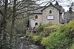
| |||
| Killin, Kinnell, Urn Gatepiers On West Drive (2Nd Of 4 Pairs) | 56°27′52″N 4°18′57″W / 56.464387°N 4.315716°W | Category C(S) | 8278 | Upload Photo | |||
| Killin, Kinnell House Including Walled Garden And Ancillary Buildings | 56°28′00″N 4°18′35″W / 56.466753°N 4.309805°W | Category B | 8283 | Upload Photo | |||
| Crianlarich, Crianlarich Parish Church (Church Of Scotland) Including Gatepiers And Boundary Walls | 56°23′31″N 4°37′00″W / 56.391885°N 4.616764°W | Category B | 50318 | Upload Photo | |||
| Killin, Manse Road, Mansefield | 56°27′54″N 4°19′14″W / 56.465079°N 4.320547°W | Category C(S) | 50332 | 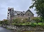
| |||
| Killin, Main Street, Masonic Lodge And White House And Manse Brae, Breadalbane Cottage | 56°27′54″N 4°19′10″W / 56.465099°N 4.319477°W | Category C(S) | 8273 | 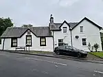
| |||
| Breadalbane Mausoleum, North Gates | 56°28′32″N 4°18′55″W / 56.475582°N 4.315408°W | Category C(S) | 8287 | Upload Photo | |||
| Auchlyne, Auchlyne Farm, Granary | 56°26′03″N 4°24′51″W / 56.434248°N 4.41408°W | Category B | 50317 | Upload Photo | |||
| Inverarnan, Glen Falloch Farm, Farmhouse Including Gatepiers | 56°20′19″N 4°43′09″W / 56.338718°N 4.719178°W | Category C(S) | 50324 | Upload Photo | |||
| Killin, Main Street, Dreadnought Place Including Ancillary Structure And Boundary Walls | 56°28′07″N 4°19′03″W / 56.468516°N 4.317429°W | Category C(S) | 50330 | .jpg.webp)
| |||
| Glen Lochay, Moirlanich Longhouse | 56°28′39″N 4°20′10″W / 56.477369°N 4.336075°W | Category A | 8263 | Upload Photo | |||
| Auchlyne, Chapel (Caibeal Na Fairge) | 56°25′58″N 4°24′46″W / 56.4327°N 4.412814°W | Category C(S) | 8265 | Upload Photo | |||
| Killin, Bridge Of Dochart Over Falls Of Dochart | 56°27′47″N 4°19′13″W / 56.462964°N 4.32024°W | Category A | 8275 | 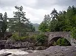
| |||
| Inverarnan, Glen Falloch Farm, Campbell Burial Enclosure | 56°20′20″N 4°43′09″W / 56.338996°N 4.719214°W | Category C(S) | 50323 | Upload Photo | |||
| Auchlyne, Auchlyne House | 56°26′02″N 4°24′55″W / 56.433864°N 4.415321°W | Category B | 8264 | Upload Photo | |||
| Inverarnan, Drover's Inn Stables And Steading | 56°19′43″N 4°43′21″W / 56.328561°N 4.722467°W | Category C(S) | 8289 | Upload Photo | |||
| Dalrigh, Drochaid Bhan, Bridge Over River Fillan | 56°25′21″N 4°41′04″W / 56.422572°N 4.684326°W | Category B | 50322 | Upload Photo | |||
| Inverarnan, Glenfalloch Lodge Including Stable | 56°19′55″N 4°43′21″W / 56.331892°N 4.722624°W | Category C(S) | 50325 | Upload Photo | |||
| Killin, Dochart Road, War Memorial | 56°27′39″N 4°19′24″W / 56.460738°N 4.323448°W | Category C(S) | 50326 | Upload Photo | |||
| Killin, Main Street, Lynedoch Including Boundary Walls | 56°28′01″N 4°19′05″W / 56.466841°N 4.31809°W | Category C(S) | 50331 | 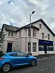
| |||
| Tyndrum, Strathfillan House, Former Bridge Of Strathfillan Parish Church And Manse, Including Gatepiers And Boundary Walls | 56°25′19″N 4°40′42″W / 56.422002°N 4.678237°W | Category B | 50335 | Upload Photo | |||
| Glenlochay House | 56°28′56″N 4°20′42″W / 56.482189°N 4.344963°W | Category C(S) | 8262 | Upload Photo | |||
| Killin, Main Street, Glengarry Including Boundary Walls | 56°27′55″N 4°19′09″W / 56.4653°N 4.319295°W | Category C(S) | 8271 | 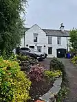
| |||
| Killin, Main Street, Birchbank Including Boundary Walls | 56°27′55″N 4°19′10″W / 56.465235°N 4.319404°W | Category C(S) | 8272 | 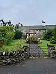
| |||
| Killin, Railway Viaduct Over River Dochart | 56°27′55″N 4°18′56″W / 56.465307°N 4.315529°W | Category A | 8281 | Upload Photo | |||
| Killin, Kinnell, Lion Gatepiers On West Drive (3Rd Of 4 Pairs) | 56°28′00″N 4°18′43″W / 56.466597°N 4.311906°W | Category C(S) | 8282 | Upload Photo | |||
| Killin, Kinnell, Ball Finial Gatepiers On South Drive (4Th Of 4 Pairs) | 56°27′49″N 4°18′20″W / 56.463605°N 4.305588°W | Category C(S) | 8284 | Upload Photo | |||
| Glendochart, Luib Hotel Including Stables | 56°25′10″N 4°26′36″W / 56.419482°N 4.443467°W | Category C(S) | 8292 | Upload Photo | |||
| Crianlarich, Lochdochart, Lochdochart House Including Boundary Walls | 56°24′48″N 4°32′28″W / 56.413448°N 4.54107°W | Category C(S) | 50320 | Upload Photo | |||
| Killin, Kinnell House, Ice House | 56°28′00″N 4°18′14″W / 56.466537°N 4.304012°W | Category C(S) | 50328 | Upload Photo | |||
| To The West Of Auchlyne, Bowachter | 56°25′26″N 4°26′17″W / 56.423778°N 4.437953°W | Category C(S) | 50333 | Upload Photo |
Key
The scheme for classifying buildings in Scotland is:
- Category A: "buildings of national or international importance, either architectural or historic; or fine, little-altered examples of some particular period, style or building type."[1]
- Category B: "buildings of regional or more than local importance; or major examples of some particular period, style or building type, which may have been altered."[1]
- Category C: "buildings of local importance; lesser examples of any period, style, or building type, as originally constructed or moderately altered; and simple traditional buildings which group well with other listed buildings."[1]
In March 2016 there were 47,288 listed buildings in Scotland. Of these, 8% were Category A, and 50% were Category B, with the remaining 42% being Category C.[2]
Notes
- ↑ Sometimes known as OSGB36, the grid reference (where provided) is based on the British national grid reference system used by the Ordnance Survey.
• "Guide to National Grid". Ordnance Survey. Retrieved 12 December 2007.
• "Get-a-map". Ordnance Survey. Retrieved 17 December 2007. - ↑ Historic Environment Scotland assign a unique alphanumeric identifier to each designated site in Scotland, for listed buildings this always begins with "LB", for example "LB12345".
References
- All entries, addresses and coordinates are based on data from Historic Scotland. This data falls under the Open Government Licence
- 1 2 3 "What is Listing?". Historic Environment Scotland. Retrieved 29 May 2018.
- ↑ Scotland's Historic Environment Audit 2016 (PDF). Historic Environment Scotland and the Built Environment Forum Scotland. pp. 15–16. Retrieved 29 May 2018.
This article is issued from Wikipedia. The text is licensed under Creative Commons - Attribution - Sharealike. Additional terms may apply for the media files.