This is a list of listed buildings in the burgh of Fort William in Highland, Scotland.
List
| Name | Location | Date Listed | Grid Ref. [note 1] | Geo-coordinates | Notes | LB Number [note 2] | Image |
|---|---|---|---|---|---|---|---|
| 4, 6, 8 High Street, Royal Bank Of Scotland, Retaining Wall And Gate Piers | 56°49′07″N 5°06′35″W / 56.818473°N 5.109783°W | Category C(S) | 31786 | 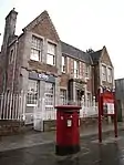
| |||
| High Street, St Andrew's Episcopal Church, Burial Ground, Lych Gate (To High Street) And Entrance To Bank Street | 56°49′08″N 5°06′32″W / 56.81875°N 5.108789°W | Category A | 31788 | 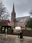
| |||
| Donald Cameron Of Lochiel Statue, The Parade | 56°49′10″N 5°06′28″W / 56.819416°N 5.107665°W | Category C(S) | 31794 | 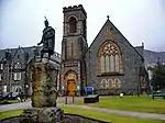
| |||
| 1-12 Inclusive Nos Seaview Terrace And Laundry Building | 56°48′53″N 5°06′54″W / 56.814739°N 5.114964°W | Category C(S) | 31795 | 
| |||
| West Highland Museum, 4, 6, 8 Cameron Square | 56°49′04″N 5°06′40″W / 56.817687°N 5.111029°W | Category B | 31781 | .jpg.webp)
| |||
| Fassifern Road, Cameron Obelisk | 56°49′04″N 5°06′33″W / 56.817772°N 5.109069°W | Category B | 31785 | 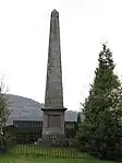
| |||
| Nevis Bridge (New) Over River Nevis | 56°49′18″N 5°05′38″W / 56.821698°N 5.093969°W | Category B | 31790 |  Upload Photo | |||
| Duncansburgh Parish Church Of Scotland, The Parade | 56°49′09″N 5°06′25″W / 56.819029°N 5.106977°W | Category B | 31792 | .jpg.webp)
| |||
| Fassifern Road, St Andrew's East And West (Former Episcopal Rectory And School), Garden Walls And Gate Piers | 56°49′05″N 5°06′25″W / 56.818046°N 5.107076°W | Category B | 31783 | Upload Photo | |||
| Fort William Primary School, Achintore Road | 56°48′51″N 5°07′01″W / 56.814267°N 5.116973°W | Category B | 43374 | .jpg.webp)
| |||
| Nevis Bridge (Old) Over River Nevis | 56°49′18″N 5°05′31″W / 56.821643°N 5.091834°W | Category B | 31791 | Upload Photo | |||
| The Highland Hotel, Union Road | 56°48′56″N 5°06′44″W / 56.815493°N 5.112158°W | Category B | 31796 | 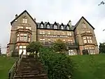
| |||
| Achintore Road, Glentower, (Former Ben Nevis Low Level Observatory) | 56°48′48″N 5°07′06″W / 56.813262°N 5.118315°W | Category B | 31779 | .jpg.webp)
| |||
| 38 High Street | 56°49′05″N 5°06′39″W / 56.817956°N 5.110707°W | Category B | 31787 | 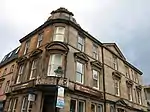
| |||
| Roman Catholic Church Of St Mary And The Immaculate Conception And Enclosing Walls With Gate Piers, Belford Road | 56°49′11″N 5°06′13″W / 56.819824°N 5.103568°W | Category A | 31780 | .jpg.webp)
| |||
| The Parade The Governor's House | 56°49′08″N 5°06′28″W / 56.818835°N 5.107879°W | Category B | 31793 | Upload Photo | |||
| The Craigs Burial Ground, Ewen Maclachlan Obelisk And Gateway | 56°49′16″N 5°06′05″W / 56.821044°N 5.101472°W | Category B | 31782 | Upload Photo | |||
| Former Macintosh Memorial Church Of Scotland (former Free Church Of Scotland), Fassifern Road | 56°49′01″N 5°06′40″W / 56.816985°N 5.111053°W | Category C(S) | 31784 | 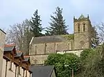
| |||
| High Street, Free Church Of Scotland And Former School | 56°48′59″N 5°06′52″W / 56.816358°N 5.114574°W | Category B | 31789 | 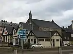 |
Key
The scheme for classifying buildings in Scotland is:
- Category A: "buildings of national or international importance, either architectural or historic; or fine, little-altered examples of some particular period, style or building type."[1]
- Category B: "buildings of regional or more than local importance; or major examples of some particular period, style or building type, which may have been altered."[1]
- Category C: "buildings of local importance; lesser examples of any period, style, or building type, as originally constructed or moderately altered; and simple traditional buildings which group well with other listed buildings."[1]
In March 2016 there were 47,288 listed buildings in Scotland. Of these, 8% were Category A, and 50% were Category B, with the remaining 42% being Category C.[2]
See also
Notes
- ↑ Sometimes known as OSGB36, the grid reference (where provided) is based on the British national grid reference system used by the Ordnance Survey.
• "Guide to National Grid". Ordnance Survey. Retrieved 12 December 2007.
• "Get-a-map". Ordnance Survey. Retrieved 17 December 2007. - ↑ Historic Environment Scotland assign a unique alphanumeric identifier to each designated site in Scotland, for listed buildings this always begins with "LB", for example "LB12345".
References
- All entries, addresses and coordinates are based on data from Historic Scotland. This data falls under the Open Government Licence
- 1 2 3 "What is Listing?". Historic Environment Scotland. Retrieved 29 May 2018.
- ↑ Scotland's Historic Environment Audit 2016 (PDF). Historic Environment Scotland and the Built Environment Forum Scotland. pp. 15–16. Retrieved 29 May 2018.
This article is issued from Wikipedia. The text is licensed under Creative Commons - Attribution - Sharealike. Additional terms may apply for the media files.