This is a list of listed buildings in the parish of Coatbridge in North Lanarkshire, Scotland.
List
| Name | Location | Date Listed | Grid Ref. [note 1] | Geo-coordinates | Notes | LB Number [note 2] | Image |
|---|---|---|---|---|---|---|---|
| Kirkshaws Road, Kirkstyle Cottages | 55°50′44″N 4°02′56″W / 55.845471°N 4.048882°W | Category B | 23017 | 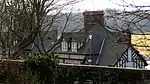
| |||
| 59-65 (Odd Nos) Main Street And 1 Church Street | 55°51′46″N 4°01′37″W / 55.862686°N 4.02684°W | Category B | 23020 |  Upload Photo | |||
| Graveyard | 55°50′42″N 4°02′59″W / 55.845088°N 4.049724°W | Category B | 22996 | Upload Photo | |||
| Drumpellier Farm | 55°51′50″N 4°03′10″W / 55.863892°N 4.052745°W | Category B | 23000 | Upload Photo | |||
| Central Station (Now Pullmans) K6 Telephone Kiosk | 55°51′45″N 4°01′53″W / 55.862541°N 4.031275°W | Category B | 23009 | Upload Photo | |||
| Hozier Street, St Mary (Rc Church) Including Presbytery, Hall, Boundary Walls And Gatepiers | 55°51′10″N 4°01′19″W / 55.852729°N 4.021912°W | Category B | 49590 | Upload Photo | |||
| Bank Street And Blair Road, Langloan Primary School With Boundary Walls, Gatepiers And Railings | 55°51′28″N 4°02′40″W / 55.85784°N 4.044372°W | Category C(S) | 49862 | 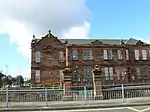
| |||
| 163 Bank Street, (Former Union Bank) Including Boundary Walls And Gatepiers | 55°51′35″N 4°02′12″W / 55.859602°N 4.036731°W | Category C(S) | 49869 | Upload Photo | |||
| 1 Ross Street And 1 - 13 (Odd Nos) Bank Street | 55°51′42″N 4°01′52″W / 55.861608°N 4.031179°W | Category C(S) | 50160 | Upload Photo | |||
| St Patrick's Roman Catholic Church, Including Walls, Piers, Gates And Fencing, Main Street, Coatbridge | 55°51′45″N 4°01′32″W / 55.86261°N 4.025462°W | Category B | 42895 | Upload Photo | |||
| Coltswood Road, Greenhill Primary School, Including Boundary Walls, Railings And Gates | 55°52′09″N 4°01′29″W / 55.869131°N 4.024603°W | Category B | 23015 | Upload Photo | |||
| 453 Main Street, Monklands District Magistrates Court | 55°51′35″N 4°00′34″W / 55.85981°N 4.009337°W | Category B | 23021 | Upload Photo | |||
| School Street, Whifflet Primary School, Including Boundary Walls, Gatepiers, Railings And Gates | 55°51′02″N 4°01′21″W / 55.850668°N 4.02262°W | Category C(S) | 23022 | Upload Photo | |||
| Weir Street, Dunbeth Church, Including Boundary Wall | 55°51′55″N 4°01′25″W / 55.865182°N 4.02371°W | Category B | 23023 | Upload Photo | |||
| Muiryhall Street East, Former Coatdyke Parish Church, Including Hall, Boundary Walls And Gatepiers | 55°51′42″N 4°00′29″W / 55.861747°N 4.007951°W | Category C(S) | 23024 | Upload Photo | |||
| Gartsherrie Parish Church | 55°51′52″N 4°01′37″W / 55.864439°N 4.02682°W | Category B | 22997 | Upload Photo | |||
| St John Street St John The Evangelist Episcopal Church | 55°51′48″N 4°01′29″W / 55.863438°N 4.02485°W | Category C(S) | 23005 | Upload Photo | |||
| 31 Muiryhall Street | 55°51′49″N 4°01′16″W / 55.863626°N 4.02104°W | Category C(S) | 23008 | Upload Photo | |||
| Chisholm Street, K6 Telephone Kiosk | 55°52′11″N 4°01′09″W / 55.869627°N 4.019035°W | Category B | 23010 | Upload Photo | |||
| Dundyvan Road, St Augustine (Rc Church) Including Sacristy, Presbytery, Hall, Boundary Walls And Gatepiers | 55°51′31″N 4°02′10″W / 55.858704°N 4.036156°W | Category B | 49591 | 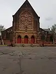
| |||
| West Canal Street And Heritage Way, Former Caledonian Railway Station, With Gatepiers And Railings | 55°51′45″N 4°01′53″W / 55.862576°N 4.031341°W | Category C(S) | 49871 | Upload Photo | |||
| West Lodge Drumpellier Park | 55°51′26″N 4°03′30″W / 55.857113°N 4.058315°W | Category B | 22998 | Upload Photo | |||
| Dundyvan Church Henderson Street Oxford Street And Kirk Street | 55°51′28″N 4°01′59″W / 55.857714°N 4.032957°W | Category B | 23001 | Upload Photo | |||
| Heritage Way, Summerlee Gatehouse Including Boundary Wall | 55°51′47″N 4°01′52″W / 55.862956°N 4.031201°W | Category C(S) | 49870 | Upload Photo | |||
| Railway And Foot Bridge Over Former Monkland Canal (West Bridge) Including Access Stair Building | 55°51′43″N 4°01′54″W / 55.861934°N 4.031579°W | Category B | 49873 | Upload Photo | |||
| 27, 29 Main Street, Coia's Building | 55°51′46″N 4°01′43″W / 55.862785°N 4.028492°W | Category C(S) | 23019 | Upload Photo | |||
| Holy Trinity And All Saints Roman Catholic Church, Muiryhall Street East And Quarry Street | 55°51′41″N 4°00′22″W / 55.861406°N 4.006239°W | Category C(S) | 23004 | 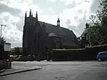
| |||
| Lamberton's Engineering Works, Sunnyside Road And Russell Colt Street | 55°52′04″N 4°01′43″W / 55.867672°N 4.028603°W | Category B | 23011 | Upload Photo | |||
| Academy Street, Carnegie Library, Including Boundary Wall And Gatepiers | 55°51′48″N 4°01′43″W / 55.863323°N 4.028552°W | Category B | 23012 | 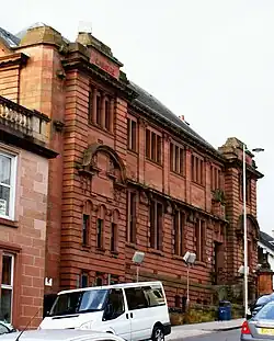
| |||
| 51 Blairhill Street, Kenilworth House | 55°51′53″N 4°02′23″W / 55.864642°N 4.039584°W | Category B | 46093 | Upload Photo | |||
| Old Monkland Church | 55°50′45″N 4°02′59″W / 55.845807°N 4.049746°W | Category B | 22995 | 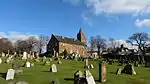
| |||
| Burial Place Of The Buchannans Of Drumpellier, West Lodge | 55°51′29″N 4°03′32″W / 55.858066°N 4.058845°W | Category B | 22999 | Upload Photo | |||
| Gartsherrie Road, Sunnyside Station | 55°52′01″N 4°01′42″W / 55.866842°N 4.028272°W | Category B | 23003 | Upload Photo | |||
| Calder Street/26 Bute Street, Calder Parish Church, Including Manse, Gatepiers And Railings | 55°51′06″N 4°01′04″W / 55.851788°N 4.017901°W | Category B | 23007 | 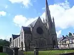
| |||
| Railway Bridge Over Coatbridge Cross | 55°51′44″N 4°01′48″W / 55.862196°N 4.029899°W | Category B | 49872 | Upload Photo | |||
| Main Street, Whitelaw Memorial Fountain | 55°51′44″N 4°01′44″W / 55.86234°N 4.028756°W | Category C(S) | 50508 | 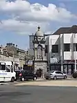
| |||
| 5 Carradale Road, Former Cattle Market, Including Lodge, Outbuilding, Gatepiers And Walls Facing West Canal Street, And Wall At Carradale Road | 55°51′41″N 4°02′04″W / 55.861446°N 4.034462°W | Category B | 23014 | Upload Photo | |||
| Albert Street, Coatbridge High School, Including Gatepiers,_Boundary Walls And Railings | 55°51′56″N 4°01′26″W / 55.865612°N 4.023781°W | Category C(S) | 23013 | Upload Photo | |||
| Dunbeth Road, Municipal Buildings, Including Boundary Walls,_Railings, Gatepiers And Gates | 55°51′50″N 4°01′19″W / 55.863838°N 4.021818°W | Category B | 23016 | 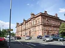
| |||
| Coats Church Jackson Street And Muiryhall Street | 55°51′47″N 4°01′09″W / 55.862957°N 4.019104°W | Category B | 23002 | Upload Photo | |||
| Gartsherrie Road, Gartsherrie Primary School | 55°52′09″N 4°02′29″W / 55.869167°N 4.041451°W | Category C(S) | 49606 | Upload Photo | |||
| Main Street, Airdrie Savings Bank | 55°51′45″N 4°01′45″W / 55.862513°N 4.029165°W | Category B | 23018 | Upload Photo | |||
| Academy Street, Gartsherrie Academy Primary School Including Playground Walls | 55°51′50″N 4°01′40″W / 55.863873°N 4.027893°W | Category B | 23006 | Upload Photo | |||
| Bank Street, Coatbridge War Memorial | 55°51′28″N 4°02′36″W / 55.857832°N 4.043221°W | Category C(S) | 50509 | 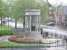 |
Key
The scheme for classifying buildings in Scotland is:
- Category A: "buildings of national or international importance, either architectural or historic; or fine, little-altered examples of some particular period, style or building type."[1]
- Category B: "buildings of regional or more than local importance; or major examples of some particular period, style or building type, which may have been altered."[1]
- Category C: "buildings of local importance; lesser examples of any period, style, or building type, as originally constructed or moderately altered; and simple traditional buildings which group well with other listed buildings."[1]
In March 2016 there were 47,288 listed buildings in Scotland. Of these, 8% were Category A, and 50% were Category B, with the remaining 42% being Category C.[2]
See also
Notes
- ↑ Sometimes known as OSGB36, the grid reference (where provided) is based on the British national grid reference system used by the Ordnance Survey.
• "Guide to National Grid". Ordnance Survey. Retrieved 12 December 2007.
• "Get-a-map". Ordnance Survey. Retrieved 17 December 2007. - ↑ Historic Environment Scotland assign a unique alphanumeric identifier to each designated site in Scotland, for listed buildings this always begins with "LB", for example "LB12345".
References
- All entries, addresses and coordinates are based on data from Historic Scotland. This data falls under the Open Government Licence
- 1 2 3 "What is Listing?". Historic Environment Scotland. Retrieved 29 May 2018.
- ↑ Scotland's Historic Environment Audit 2016 (PDF). Historic Environment Scotland and the Built Environment Forum Scotland. pp. 15–16. Retrieved 29 May 2018.
This article is issued from Wikipedia. The text is licensed under Creative Commons - Attribution - Sharealike. Additional terms may apply for the media files.