This is a list of listed buildings in the Civil Parish of Castle Douglas in the historical county of Kirkcudbrightshire in Dumfries and Galloway, Scotland.
List
| Name | Location | Date Listed | Grid Ref. [note 1] | Geo-coordinates | Notes | LB Number [note 2] | Image |
|---|---|---|---|---|---|---|---|
| 114-118 (Even Nos) Queen Street | 54°56′21″N 3°55′48″W / 54.939093°N 3.92997°W | Category C(S) | 22977 |  Upload Photo | |||
| 11-15 (Odd Nos) St Andrews Street And King Street, The Douglas Arms Hotel | 54°56′21″N 3°55′55″W / 54.939285°N 3.932056°W | Category C(S) | 22980 | Upload Photo | |||
| Kelton Manse Of Kelton Stables | 54°55′23″N 3°56′13″W / 54.92294°N 3.936874°W | Category C(S) | 22972 | Upload Photo | |||
| Lochbank With Gatepiers And Boundary Walls | 54°55′47″N 3°56′14″W / 54.929622°N 3.937211°W | Category B | 50124 | Upload Photo | |||
| 210 And 212 King Street And 32 St Andrew Street | 54°56′20″N 3°55′56″W / 54.93902°N 3.932308°W | Category C(S) | 50164 | Upload Photo | |||
| Furbar | 54°55′41″N 3°56′26″W / 54.927923°N 3.940563°W | Category B | 22971 | Upload Photo | |||
| 122-126 (Even Nos) Queen Street | 54°56′20″N 3°55′48″W / 54.938992°N 3.930106°W | Category C(S) | 22978 | Upload Photo | |||
| 66 St Andrew Street | 54°56′15″N 3°55′45″W / 54.937525°N 3.929115°W | Category B | 49413 | Upload Photo | |||
| 193 & 195 King Street, The Merrick Hotel | 54°56′21″N 3°55′54″W / 54.93903°N 3.931716°W | Category C(S) | 50048 | Upload Photo | |||
| Threave Lodge And Gates | 54°55′37″N 3°56′25″W / 54.926806°N 3.94015°W | Category C(S) | 22984 | Upload Photo | |||
| Littlebank (Former Lodge To Lochbank), With Boundary Walls | 54°55′46″N 3°56′15″W / 54.929581°N 3.93749°W | Category C(S) | 50125 | Upload Photo | |||
| Abercromby Road, St John The Evangelist, Rc Church, Presbytery And Retaining Walls | 54°56′24″N 3°56′00″W / 54.94012°N 3.933235°W | Category C(S) | 22970 | Upload Photo | |||
| Kirkland House And Gatepiers | 54°55′36″N 3°56′21″W / 54.92676°N 3.939134°W | Category B | 22975 | Upload Photo | |||
| Abercromby Road, Kilmichael - Outbuilding Formerly Old House Of Fuffnock | 54°56′41″N 3°56′27″W / 54.944745°N 3.94078°W | Category C(S) | 22969 | Upload Photo | |||
| 131-133 (Odd Nos) King Street, Royal Bank Scotland | 54°56′25″N 3°55′49″W / 54.940195°N 3.930195°W | Category B | 22973 | Upload Photo | |||
| New Market Street Castle Douglas Cattle Mart | 54°56′33″N 3°55′28″W / 54.942479°N 3.924496°W | Category A | 22976 | 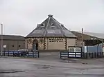
| |||
| St Andrew Street, Town Hall And Customs House | 54°56′23″N 3°55′57″W / 54.9396°N 3.93257°W | Category B | 22979 | Upload Photo | |||
| Marle Street And Lochside Road, Lochside Theatre Former St Andrews Parish Church (Church Of Scotland) With Retaining Walls, Railings, Piers And Lamp Standards | 54°56′13″N 3°55′51″W / 54.937048°N 3.930871°W | Category C(S) | 22981 | Upload Photo | |||
| St Andrew Street, The Brae | 54°56′18″N 3°55′43″W / 54.938432°N 3.928612°W | Category B | 22982 | Upload Photo | |||
| St Andrew Street, The Grove | 54°56′15″N 3°55′38″W / 54.937364°N 3.927358°W | Category C(S) | 22983 | Upload Photo | |||
| King Street, Castle Douglas Library With Art Gallery, Boundary Wall, Railings, Gates And Gatepiers | 54°56′32″N 3°55′38″W / 54.94212°N 3.927305°W | Category B | 49671 | 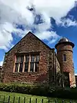
| |||
| 35 King Street, Imperial Hotel | 54°56′32″N 3°55′41″W / 54.942207°N 3.928043°W | Category B | 22974 | 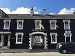
| |||
| Whitepark Road, St Ninians Episcopal Church | 54°56′13″N 3°55′41″W / 54.936821°N 3.928175°W | Category B | 22985 | Upload Photo |
Key
The scheme for classifying buildings in Scotland is:
- Category A: "buildings of national or international importance, either architectural or historic; or fine, little-altered examples of some particular period, style or building type."[1]
- Category B: "buildings of regional or more than local importance; or major examples of some particular period, style or building type, which may have been altered."[1]
- Category C: "buildings of local importance; lesser examples of any period, style, or building type, as originally constructed or moderately altered; and simple traditional buildings which group well with other listed buildings."[1]
In March 2016 there were 47,288 listed buildings in Scotland. Of these, 8% were Category A, and 50% were Category B, with the remaining 42% being Category C.[2]
Notes
- ↑ Sometimes known as OSGB36, the grid reference (where provided) is based on the British national grid reference system used by the Ordnance Survey.
• "Guide to National Grid". Ordnance Survey. Retrieved 12 December 2007.
• "Get-a-map". Ordnance Survey. Retrieved 17 December 2007. - ↑ Historic Environment Scotland assign a unique alphanumeric identifier to each designated site in Scotland, for listed buildings this always begins with "LB", for example "LB12345".
References
- All entries, addresses and coordinates are based on data from Historic Scotland. This data falls under the Open Government Licence
- 1 2 3 "What is Listing?". Historic Environment Scotland. Retrieved 29 May 2018.
- ↑ Scotland's Historic Environment Audit 2016 (PDF). Historic Environment Scotland and the Built Environment Forum Scotland. pp. 15–16. Retrieved 29 May 2018.
This article is issued from Wikipedia. The text is licensed under Creative Commons - Attribution - Sharealike. Additional terms may apply for the media files.