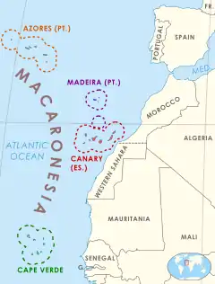
Macaronesia
This is a list of islands in Macaronesia, as ordered by area, max altitude and population.
Islands over 10 square kilometres (3.9 sq mi)
Islands under 10 square kilometres (3.9 sq mi)
| Rank | Island's Name | Area (km2) | Area (sq mi) | Height (m) | Location | Population | Density (per km2) |
|---|---|---|---|---|---|---|---|
| 32 | Lobos | 4.679 | 4 | 0 | |||
| 33 | Bugio | 3 | 0 | 0 | |||
| 34 | Ilhéu Grande | 3 | 0 | 0 | |||
| 35 | Ilhéu Branco | 2.78 | 0 | 0 | |||
| 36 | Selvagem Grande | 2.45 | 0 | 0 | |||
| 37 | Ilhéu de Cima | 1.5 | 0 | 0 | |||
| 38 | Montaña Clara | 1.33 | 0 | 0 | |||
| 39 | Roque del Este | 0.1 | 0 | 0 | |||
References
- 1 2 3 4 5 "Estadística del Territorio" [Territory Statistics] (in Spanish). Instituto Canario de Estadística (ISTAC). Retrieved 2019-07-17.
- ↑ "This statistic displays the population of the Spanish autonomous community of the Canary Islands* in January 2020, by island". Statista.com. October 2020. Retrieved 17 June 2020.
- ↑ "Real Decreto 1458/2018, de 14 de diciembre, por el que se declaran oficiales las cifras de población resultantes de la revisión del Padrón municipal referidas al 1 de enero de 2019" [Royal Decree 1458/2018, of 14 December, by which the population values resulting from the review of the municipal register of 01 January 2019 are declared official] (PDF). BOE (in Spanish). 2018-12-29. Retrieved 2019-08-14.
- ↑ Population referred to the January 1, 2019 Archived 31 January 2019 at the Wayback Machine
- ↑ "Geografia São Miguel". iaram.azores.gov.pt. Azores Government. Retrieved 9 January 2021.
- ↑ "This statistic displays the population of the Spanish autonomous community of the Canary Islands* in January 2020, by island". Statista.com. October 2020. Retrieved 17 June 2020.
- ↑ "Geografia Pico". iaram.azores.gov.pt. Azores Government. Retrieved 11 January 2021.
- 1 2 3 4 5 6 7 8 9 "INE - Plataforma de divulgação dos Censos 2021 – Resultados Preliminares". censos.ine.pt. Retrieved 9 November 2021.
- ↑ "Geografia Terceira". Azores Government. Retrieved 13 January 2021.
This article is issued from Wikipedia. The text is licensed under Creative Commons - Attribution - Sharealike. Additional terms may apply for the media files.