
Fracture zones are common features in the geology of oceanic basins. Globally most fault zones are located on divergent plate boundaries on oceanic crust. This means that they are located around mid-ocean ridges and trend perpendicular to them. The term fracture zone is used almost exclusively for features on oceanic crust; similar structures on continental crust are instead termed transform or strike slip faults. The term fracture zone has a distinct geological meaning, but it is also used more loosely in the naming of some oceanic features. Fracture zones are much longer than wide, but may have feature complexity within their width. Not all named fracture zones are active, indeed only the central portion of those still forming usually is, in an area of active transform faulting associated with a mid-ocean ridge. Classic fracture zones remain significant ocean floor features with usually different aged rocks on either side of the fracture zone due to past tectonic processes. Some fracture zones have been created by mid-ocean ridge segments that have been subducted and that part may no longer exist.
Pacific Ocean
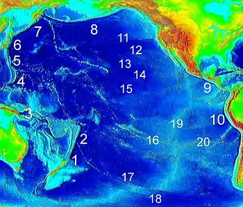
Most fracture zones in the Pacific Ocean originate from large mid-ocean ridges (also called "rises") such as the East Pacific Rise, Chile Rise and Juan de Fuca Ridge. The plates that host the fractures are Nazca, Pacific, Antarctic, Juan de Fuca and Cocos among others. Fracture zones being subducted under Southern and Central America are generally southwest-northeast oriented reflecting the relative motion of Cocos, Nazca and the Antarctic Plates.
Chile Rise
The fracture zones of the Chile Rise trend in a west to east fashion with the most southern ones taking a slightly more southwest to northeast orientation. This non-perpendicular relation to Chile's coast reflects the oblique subduction of Nazca Plate under southern Chile. West of Chile rise the fracture zones are hosted in the Antarctic Plate. Some fracture zones such as Chile and Valdivia make up large sections of the Nazca-Antarctic Plate boundary.


| Name | Minimum length in km | Length of transform boundary in km | Position at Ridge[1][2] |
|---|---|---|---|
| Chile Fracture Zone | 2,250 (1,400) | 1,100 (680) | 35°32′24″S 104°37′3″W / 35.54000°S 104.61750°W |
| Chiloé Fracture Zone | 1,750 (1,090) | 50 (30) | 42°59′43″S 83°11′5″W / 42.99528°S 83.18472°W |
| Darwin Fracture Zone | 50 (30) | 45°54′29″S 76°25′31″W / 45.90806°S 76.42528°W | |
| Desolación Fracture Zone | 0 | ||
| Esmeralda Fracture Zone | 0 | 49°06′47″S 80°12′33″W / 49.11306°S 80.20917°W | |
| Guafo Fracture Zone | 1,550 (960) | 280 (170) | 44°47′55″S 80°15′53″W / 44.79861°S 80.26472°W |
| Guambin Fracture Zone | 1,300 (810) | 70 (40) | 45°44′7″S 77°27′32″W / 45.73528°S 77.45889°W |
| Madre de Dios Fracture Zone | 0 | ||
| Mocha Fracture Zone | 450 (280) | 0 | 39°14′24″S 77°22′59″W / 39.24000°S 77.38306°W |
| Taitao Fracture Zone | 0 | ||
| Tres Montes Fracture Zone | 0 | ||
| Valdivia Fracture Zone | 2,100 (1,300) | 650 (400) | 41°23′25″S 87°23′36″W / 41.39028°S 87.39333°W |
East Pacific Rise
The East Pacific Rise includes the Pacific-Antarctic Rise (Pacific Plate and Antarctic Plate boundary) in some usages and in others relates only to the boundaries between the Pacific Plate and the Nazca Plates which includes the Juan Fernández Plate and Easter Microplate.
Nazca Plate boundary
| Name | Minimum length in km | Length as plate boundary in km | Coordinates |
|---|---|---|---|
| Easter Fracture Zone | |||
| Mendaña Fracture Zone | 0 | ||
| Nazca Fracture Zone | 0 | 19°49′28″S 77°35′53″W / 19.82444°S 77.59806°W[2] | |
| Quiros Fracture Zone | 0 |
Pacific-Antarctic Rise
| Name | Minimum length in km | Length as plate boundary in km | Coordinates |
|---|---|---|---|
| Challenger Fracture Zone | |||
| Menard Fracture Zone | 0 | ||
| Raitt Fracture Zone | 0 | ||
| Eltanin Fracture Zone | 0 | ||
| Heezen Fracture Zone | 0 | ||
| Tharp Fracture Zone | 0 | ||
| Udintsev Fracture Zone | 0 | ||
| Le Géographe Fracture Zone | 0 | ||
| Astronome Fracture Zone | 0 | ||
| Antipodes Fracture Zone | 0 | ||
| Le Petit Prince Fracture Zone | 0 | ||
| Saint-Exupéry Fracture Zone | 0 | ||
| Le Renard Fracture Zone | 0 | ||
| La Rose Fracture Zone | 0 | ||
| Heirtzler Fracture Zone | 0 | ||
| Pitman Fracture Zone | 0 | ||
| Erebus Fracture Zone | 0 |
Galapagos Rise
Western Pacific
Some of the fracture zones in the western Pacific Ocean are associated with the smaller plate boundaries of the active back-arc basin spreading center of the North Fiji Basin being the Hunter Fracture Zone and North Fiji Fracture Zone. The Parece Vela Rift (Parece Vela Fracture Zone Province) is also associated with the back-arc basin of the Parece Vela Basin (West Mariana Basin) at the intersection of the Philippine Sea Plate and Mariana Plate.[3]: 70–73
South of the Equator
- Vening Meinesz Fracture Zone
- Cook Fracture Zone
- Hunter Fracture Zone
- North Fiji Fracture Zone
North of the Equator
- Victoria Fracture Zone
- Central Fracture Zone
- Parece Vela Rift (Parece Vela Fracture Zone Province)
- Kokugan Fracture Zone
- Owashi Fracture Zone
- Ojirowashi Fracture Zone
- Inuwashi Fracture Zone
- Konotori Fracture Zone
- Toki Fracture Zone
- Tancho Fracture Zone
- Raicho Fracture Zone
- Ortelius Fracture Zone
- Waghenaer Fracture Zone
- Rat Fracture Zone
West of East Pacific Rise and Gulf of California Rift Zone


(some are inactive)[4]
- Challenger Fracture Zone
- Austral Fracture Zone[4]
- Marquesas Fracture Zone[4]
- Galapagos Fracture Zone[4]
- Clipperton Fracture Zone[4]
- Clarion Fracture Zone[4]
Juan de Fuca and Gorda Ridges
Surveyor, Molokai, Pioneer and Murray fracture zones shown in the list were created by ridge segments that no longer exist.[4]
- Blanco Fracture Zone
- Surveyor Fracture Zone[4]
- Mendocino Fracture Zone[4]
- Pioneer Fracture Zone[4]
- Murray Fracture Zone[4]
- Molokai Fracture Zone[4]
- Sovanco Fracture Zone
Northeast Pacific
- Sedna Fracture Zone
- Sila Fracture Zone
- Aja Fracture Zone
- Cobb Fracture Zone
Atlantic Ocean


In the Atlantic Ocean most fracture zones originate from the Mid-Atlantic Ridge, which runs from north to south, and are therefore west to east oriented in general. There are about 300 fracture zones, with an average north-south separation of 55 kilometres (34 mi):[5] two for each degree of latitude. Physically it makes sense to group Atlantic fracture zones into three categories:[6]
- Small offset: length of transform fault less than 30 kilometres (19 mi)
- Medium offset: offset over 30 kilometers
- Large offset: offset several hundreds of kilometers
Mid-Atlantic Ridge (Northern Hemisphere)
Fracture zones involved in the early opening of the North Atlantic
| American side | African side |
|---|---|
| Hudson Fracture Zone | |
| Snorri Fracture Zone | |
| Cartwright Fracture Zone | |
| Julian Haab Fracture Zone | |
| Minna Fracture Zone | |
| Leif Fracture Zone | |
| Newfoundland Fracture Zone[11] | |
| Kelvin Fracture Zone[12] | Canary Fracture Zone[12] |
| Cape Fear Fracture Zone[12] | Cape Verde Fracture Zone[12] |
| Bahama Fracture Zone[12] | Guinea Fracture Zone[12] |
Mid-Atlantic Ridge (Southern Hemisphere)
Indian Ocean
The Indian Ocean fracture zones are mainly related to the Southwest Indian Ridge and Southeast Indian Ridge mid-ocean ridges.

- Diamantina Fracture Zone (not a true fracture zone)[13]
Southwest Indian Ridge
- Bouvet Fracture Zone
- Moshesh Fracture Zone
- Islas Orcadas Fracture Zone
- Shaka Fracture Zone
- Dutoit Fracture Zone
- Prince Edward Fracture Zone
- Discovery II Fracture Zone
- Indomed Fracture Zone
- Gallieni Fracture Zone
- Atlantis II Fracture Zone[14]
- Novara Fracture Zone[14]
- Melville Fracture Zone[14]
Carlsberg Ridge
Central Indian Ridge
- Bao Chuan Fracture Zone
- Mabahiss Fracture Zone
- Sealark Fracture Zone
- Vityaz Fracture Zone
- Vema Fracture Zone (not to be confused with fracture zone of same name in the Atlantic)
- Argo Fracture Zone
- Mary Celeste Fracture Zone
- Rodrigues Fracture Zone
- Mauritius Fault Zone
- Egeria Fracture Zone
- Flinders Fracture Zone
Lakshadweep-Chagos Ridge
- Vishnu Fault Zone
Southeast Indian Ridge
- Ter Tholen Fracture Zone
- Zeewolf Fracture Zone
- Nieuw Amsterdam Fracture Zone
- Vlamingh Fracture Zone
- Geelvinck Fracture Zone
- Zeehaen Fracture Zone
- Heemskerck Fracture Zone
- Saint Vincent Fracture Zone
- Gambier Fracture Zone
- Tasman Fracture Zone
- Balleny Fracture Zone
Southern Ocean

- Endurance Fault Zone
- Hjort Fracture Zone
- Emerald Fracture Zone
- Hero Fault Zone
- Kosminskaya Fracture Zone
- Quest Fault Zone
- Shackleton Fracture Zone
- Vinogradov Fracture Zone
- Proto Antipodes Fracture Zone[15]
References
- 1 2 3 4 5 6 7 8 9 10 11 12 13 14 15 16 17 18 19 20 21 22 23 24 25 26 27 28 29 30 31 32 33 34 35 36 37 38 39 40 Name from GEBCO gazetteer, position refined by means of etopo2 and sample data of GPlates
- 1 2 3 4 "Marine Gazetteer:fracture zone". Retrieved 25 October 2023.
- ↑ Sdrolias, M; Roest, WR; Müller, RD (2 December 2004). "An expression of Philippine Sea plate rotation: the Parece Vela and Shikoku basins". Tectonophysics. 394 (1–2): 69–86. doi:10.1016/j.tecto.2004.07.061.
- 1 2 3 4 5 6 7 8 9 10 11 12 Kruse, SE; McCarthy, MC; Brudzinski, MR; Ranieri, ME (10 June 1996). "Evolution and strength of Pacific fracture zones". Journal of Geophysical Research: Solid Earth. 101 (B6): 13731–40. doi:10.1029/96JB00645.
- ↑ Gilman, Larry; Lerner, K. Lee. "Mid-Ocean-Ridges". Water Encyclopedia. Retrieved 2011-11-29.
- 1 2 3 4 5 6 7 8 9 10 11 12 Müller, R. Dietmar; Roest, Walter R. (1992). "Fracture Zones in the North Atlantic from Combined Geosat and Seasat Data" (PDF). Journal of Geophysical Research. 97 (B3): 3337–50. Bibcode:1992JGR....97.3337M. doi:10.1029/91JB02605. Archived from the original (PDF) on 2012-03-28. Retrieved 2011-11-30.
- ↑ Udintsev, G.B. (1996). "Equatorial Segment of the Mid-Atlantic Ridge". Unesco. Archived from the original on 2012-09-07. Retrieved 2011-12-05.
- 1 2 3 Roest, W. R.; Collette, B. J. (1986). "The Fifteen Twenty Fracture Zone and the North American – South American plate boundary". Journal of the Geological Society. 143 (5): 833–43. Bibcode:1986JGSoc.143..833R. doi:10.1144/gsjgs.143.5.0833. S2CID 128413673.
- ↑ Tucholke, Brian E.; Schouten, Hans (1988-03-01). "Kane Fracture Zone". Marine Geophysical Research. 10 (1–2): 1–39. Bibcode:1988MarGR..10....1T. doi:10.1007/BF02424659. S2CID 129456202.
- 1 2 "Map with Jan Mayen, Greenland and Senja Fracture Zones". Ocean Drilling Project. Retrieved 2011-12-16.
- ↑ Auzende, J.M.; Olivet, J.L.; Bonnin, J. (1970). "Marge du Grand Bank et la fracture de Terre-Neuve". Compt. Rend. (in French). 271: 1063–66.
- 1 2 3 4 5 6 Le Pichon, Xavier; Fox, Paul J. (1971-09-10). "Marginal Offsets, Fracture Zones, and the Early Opening of the North Atlantic". Journal of Geophysical Research. 76 (26): 6294–308. Bibcode:1971JGR....76.6294L. doi:10.1029/JB076i026p06294.
- ↑ "IHO-IOC GEBCO Gazetteer of Undersea Feature Names, March 2011 version; www.gebco.net". GEBCO. Archived from the original on 2012-04-21. Retrieved 2011-11-16.
- 1 2 3 Patriat, P., Sauter, D., Munschy, M., & Parson, L. (1997). A survey of the Southwest Indian Ridge axis between Atlantis II Fracture Zone and the Indian Ocean Triple Junction: Regional setting and large scale segmentation. Marine Geophysical Researches, 19(6), 457–80.
- ↑ Wobbe, F; Gohl, K; Chambord, A; Sutherland, R (2012). "Structure and breakup history of the rifted margin of West Antarctica in relation to Cretaceous separation from Zealandia and Bellingshausen plate motion". Geochemistry, Geophysics, Geosystems. 13 (4). doi:10.1029/2011GC003742.
- Sources