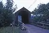
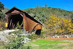
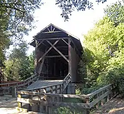
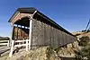
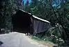
Below is a list of covered bridges in California. There are ten authentic covered bridges in the U.S. state of California, and eight of them are historic.[1] A covered bridge is considered authentic not due to its age, but by its construction. An authentic bridge is constructed using trusses rather than other methods such as stringers, a popular choice for non-authentic covered bridges.

List

Name Image County Location Built Length Crosses Ownership Truss Notes
Berta's Ranch Covered Bridge[1] Berta's Ranch Covered Bridge Humboldt Rosewood
40°43′28″N 124°10′37″W / 40.72444°N 124.17694°W / 40.72444; -124.17694 (Berta's Ranch Covered Bridge)
1936 52 feet (16 m) Elk River Queen
Bridgeport Covered Bridge[2] Bridgeport Covered Bridge Nevada French Corral
39°17′33″N 121°11′42″W / 39.29250°N 121.19500°W / 39.29250; -121.19500 (Bridgeport Covered Bridge)
1862 233 feet (71 m) South Yuba River Nevada County Division of Highways Howe and arch
Brookwood Covered Bridge[1] Humboldt Bayside
40°49′55″N 124°2′44″W / 40.83194°N 124.04556°W / 40.83194; -124.04556 (Brookwood Covered Bridge)
1969 66 feet (20 m) Jacoby Creek Howe
California Powder Works Bridge[2] California Powder Works Bridge Santa Cruz Santa Cruz
37°0′38″N 122°2′38″W / 37.01056°N 122.04389°W / 37.01056; -122.04389 (California Powder Works Bridge)
1872 180 feet (55 m) San Lorenzo River Private Smith Also called Masonic Park Covered Bridge
Felton Covered Bridge[2] Felton Covered Bridge Santa Cruz Felton
37°03′03″N 122°04′15″W / 37.05083°N 122.07083°W / 37.05083; -122.07083 (Felton Covered Bridge)
1892 163 feet (50 m) San Lorenzo River County of Santa Cruz Pratt-Warren
Knight's Ferry Bridge[2] Knight's Ferry Bridge Stanislaus Knight's Ferry
37°39′48″N 120°27′44″W / 37.66333°N 120.46222°W / 37.66333; -120.46222 (Knight's Ferry Bridge)
1864 379 feet (116 m)[3] Stanislaus River U.S. Army Corps of Engineers, Sacramento District Howe
Oregon Creek Covered Bridge[2] Oregon Creek Covered Bridge Yuba North San Juan
39°23′48″N 121°4′52″W / 39.39667°N 121.08111°W / 39.39667; -121.08111 (Oregon Creek Covered Bridge)
1860 105 feet (32 m) Oregon Creek County of Yuba Queen Also called Freeman's Crossing Covered Bridge
Simpson Ranch Covered Bridge[1] Placer Meadow Vista
39°0′36″N 121°0′40″W / 39.01000°N 121.01111°W / 39.01000; -121.01111 (Simpson Ranch Covered Bridge)
22 feet (6.7 m) Wooley Creek King Also called Foothill Roots Farm Covered Bridge
Wawona Covered Bridge[2] Wawona Covered Bridge Mariposa Wawona
37°32′19″N 119°39′17″W / 37.53861°N 119.65472°W / 37.53861; -119.65472 (Wawona Covered Bridge)
1868, 1878, 1956 138 feet (42 m) South Fork, Merced River Yosemite National Park Modified queen
Zane's Ranch Covered Bridge[1] Zane's Ranch Covered Bridge Humboldt Rosewood
40°43′4″N 124°10′8″W / 40.71778°N 124.16889°W / 40.71778; -124.16889 (Zane's Ranch Covered Bridge)
1937 52 feet (16 m) Elk River Queen

See also

References

  1. 1 2 3 4 5 Caswell, William S. World Guide to Covered Bridges (2021 ed.). Concord, New Hampshire: National Society for Preservation of Covered Bridges. pp. 3–4. ISBN 978-0-578-30263-8.
  2. 1 2 3 4 5 6 "National Register Information System". National Register of Historic Places. National Park Service. July 9, 2010.
  3. "Updates to the 2021 World Guide to Covered Bridges" (PDF). National Society for Preservation of Covered Bridges. 28 June 2022. Retrieved 6 July 2022.
This article is issued from Wikipedia. The text is licensed under Creative Commons - Attribution - Sharealike. Additional terms may apply for the media files.