List of counties of England and Wales in 1964 by highest point. In 1964 they are more or less the ancient counties, with the addition of the County of London and a number of historic divisions in place as administrative counties: Cambridgeshire into the Isle of Ely and Cambridgeshire; Hampshire into the Isle of Wight and Hampshire; Lincolnshire into the Parts of Holland, Kesteven and Lindsey; Northamptonshire into Soke of Peterborough and Northamptonshire; Suffolk into East and West; Sussex into East and West; and Yorkshire into the East, North and West Ridings.[1][2][3]
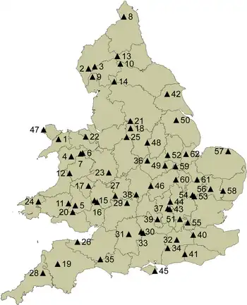
England and Wales, showing county tops in 1964
Footnotes
- The foot measurement is derived from the Ordnance Survey metre measurement, multiplied by 3.2808.
References
- ↑ Simon Edwardes (2001). "Historic County Tops". The Mountains of England and Wales. Retrieved 31 July 2010.
- ↑ Simon Edwardes (2001). "English Counties". The Mountains of England and Wales. Retrieved 31 July 2010.
- ↑ Jonny Muir (5 October 2011). The UK's County Tops: Reaching the top of 91 historic counties. Cicerone Press Limited. pp. 5–. ISBN 978-1-84965-553-8.
- ↑ Kent, Jeff, Staffordshire's 1,000-Foot Peaks, Witan Books, 2013, ISBN 978-0-9927505-0-3.
External links
- County tops of the British Isles on Wikishire (by traditional counties)
- Hill Bagging
| British Isles |  | |
|---|---|---|
| Scotland | ||
| Outside Scotland | ||
| England | ||
| Ireland | ||
| County tops | ||
This article is issued from Wikipedia. The text is licensed under Creative Commons - Attribution - Sharealike. Additional terms may apply for the media files.